CA - Jonathan Gerrish, Ellen Chung, daughter, 1 & dog, suspicious death hiking area, Aug 2021 #4

Status
Not open for further replies.
  • #541
OK, so this is an odd piece of information I share only because it appears to be a similar death mystery on a Mariposa County trail in the Hite's Cove area, in 2007.

My sleuthing skills are too limited to find the final autopsy / toxicology reports / investigation results, including where exactly Mr. LJ was found.

Can anyone else?

2007
"...two hikers in the Hite’s Cove area came upon the body of a naked man in the trail.... The cause of death has not been determined, and toxicology tests are pending, “There was no obvious trauma to the body,” Undersheriff Brian Muller told the Mariposa Gazette.... [The man] stayed at the Mariposa Lodge and had rented a car in the area.... His rental car was recovered in Oakhurst, about 25 miles from Mariposa."
https://www.marinij.com/2007/11/16/body-near-yosemite-identified-as-missing-greenbrae-man

BBM

ETA: LJ's obituary. He had a PhD in plasma physics and was a professor of Physics at Dominican University of California in San Rafael.
https://www.legacy.com/us/obituaries/marinij/name/leslie-jerde-obituary?pid=97643688

A quite interesting find.

It appears he was more than just a drycleaning businessman.

https://www.corporationwiki.com/California/Corte-Madera/leslie-jerde/44528292.aspx

Leslie Jerde Inventions, Patents and Patent Applications - Justia Patents Search

JERDE ENTERPRISES II, INC. - Address, Director information
 
Last edited:
  • #542
@MrsEmmaPeel, you are my hero. I found the same article a few days ago and never made a note of it. I was pulling my hair out trying to find it again. My dh was unsympathetic, lol! FWIW, I believe the author has written a book that you can find on Amazon. He sounds like quite a character. Off to tell dh…vindicated!

Great minds, @Parsnip :) So glad I found it. Say hello to your DH!
 
  • #543
Sorry but this is not my understanding. They didn’t take the HCT - they drove along Hites Cove Road which is not the same as the HCT. They parked their vehicle at the point where Hites Cove Road forks to continue towards the SL Trail or towards Marble Point. They don’t actually ever touch the popular HCT but continue down from Marble Point to the South Fork of the Merced River past Sims Cove and on to the base of the steep incline towards Devils Gulch on the SL trail. I think this is why a lot of people are confused about the route that was taken and why I have so much difficulty understanding why anyone would take the route they allegedly did. MOO

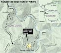
The fork in the (Hites Cove Rd.) road as I interpret — as depicted by Bing Maps — splits into Hites Cove Trail (to the NW) and (continues the) Hites Cove Road (to the East).

Here is a screen shot from Bing maps. I highlighted the names of the two paths/roads and marked the split with a highlighted circle. If the road names are difficult to read, you can view the Bing Map
 

Attachments

  • bing-screenshot.jpg
    bing-screenshot.jpg
    141 KB · Views: 56
Last edited:
  • #544
  • #545
Here's another hiking death near Hites Cove and the Savage-Lundy trail. https://www.mercedsunstar.com/news/local/community/mariposa-and-yosemite/article3264715.html

Mariposa resident Edgar Uebner, 68, was found dead Thursday at the bottom of the Merced River Canyon below the Savage-Lundy trail near the edge of the river's South Fork.

Uebner was reported missing Thursday to the Mariposa County Sheriff's Office. The California Highway Patrol reported that a hiker found items belonging to Uebner along the side of the trail.
After investigators found Uebner's vehicle at the trailhead's parking lot, a search and rescue team scoured the area and found his body.
ETA Date was in February 2012
ETA2 If you look up his obit, it implies he died while doing something he loved. I couldn't find any other info.
 
Last edited:
  • #546
The fork in the (Hites Cove Rd.) road as I interpret — as depicted by Bing Maps — splits into Hites Cove Trail (to the NW) and (continues the) Hites Cove Road (to the East).

Here is a screen shot from Bing maps. I highlighted the names of the two paths/roads and marked the split with a highlighted circle. If the road names are difficult to read, you can view the Bing Map
For convenience, I've just referred to the right fork from the location of their parked truck as the Savage Lundy Trail, the left fork as the Hites Cove Trail. The road they drove in on is the Hites Cove Rd. This map is pretty good, the route in Tony Krizan's article "Try Braving a Reverse Hike" went down the Hites Cove Trail and continued off this map into the upper left corner.
 

Attachments

  • Loop Hike.jpg
    Loop Hike.jpg
    166.6 KB · Views: 428
  • #547
Here is a column from 2007 describing a Hites Cove Trail hike in May down to the Merced River. High temp, in May, of 94 degrees. I'm not sure this is the same trail, but I know others here will know. If nothing more, it gives a good feeling of what the Gerrish-Chung hike was like, minus the Aug temperatures.

Great find! I can see how the switchbacks might have theoretically have seemed like an easier climb.
 
  • #548
  • #549
For convenience, I've just referred to the right fork from the location of their parked truck as the Savage Lundy Trail, the left fork as the Hites Cove Trail. The road they drove in on is the Hites Cove Rd. This map is pretty good, the route in Tony Krizan's article "Try Braving a Reverse Hike" went down the Hites Cove Trail and continued off this map into the upper left corner.

Yes, your attachment (map) is very good. I had not seen that map before.

After I saw post 293 and followed the Google Earth and Bing Map links, I was able to comprehend the lay of the land and see the effect the recent fires had on the area. Zooming in on the barren switchbacks on the SLT and thinking about the temps that day is alarming, for sure :( -- in my opinion
 
  • #550
Yes, your attachment (map) is very good. I had not seen that map before.

After I saw post 293 and followed the Google Earth and Bing Map links, I was able to comprehend the lay of the land and see the effect the recent fires had on the area. Zooming in on the barren switchbacks on the SLT and thinking about the temps that day is alarming, for sure :( -- in my opinion

Hi Jabchick!
Comparing your map to the one posted by LexP, does this mean that the Savage Lundy trail is actual a segment of the Hite Cove Road?
 
  • #551
For convenience, I've just referred to the right fork from the location of their parked truck as the Savage Lundy Trail, the left fork as the Hites Cove Trail. The road they drove in on is the Hites Cove Rd. This map is pretty good, the route in Tony Krizan's article "Try Braving a Reverse Hike" went down the Hites Cove Trail and continued off this map into the upper left corner.
Thank you @Lex Parsimoniae for another graphic to add to my earlier MSM notes:
loop-hike-jpg.313952


Thank you @Lex Parsimoniae - adding my own MSM notes to use your map for reference.

hites-cove-savage-lundy-loop-jpg.312591


bf095731-35e3-4d59-a63d-5971aa5a11e9-jpeg.312594


Mariposa residents John Gerrish, Ellen Chung, their daughter, Miju, and family dog, Oski, were found dead Tuesday on the Savage-Lundy Trail in Devil’s Gulch near Hites Cove.

Briese said the deceased family was found a couple miles from the south fork of the Merced River.


Briese said the family was found about 1.5 miles from their vehicle, a gray truck. It was parked at a trailhead down Hites Cove Road past the Jerseydale Sierra National Forest station and community of Mariposa Pines.

That remote trailhead along a dirt road is north of Highway 49 and east of Highway 140. It’s different from another popular trailhead to the Hites Cove area along Highway 140 in the river canyon closer to Yosemite.

A Mariposa County Sheriff’s Office official stopped some media Wednesday afternoon along Hites Cove Road near the Hites Cove Helipad, past Apperson Mine Road, stating the scene ahead was closed. Search and rescue crews took the bodies of the Mariposa family out later that afternoon.

The Savage-Lundy Trail – described by Briese as a steep, established and popular trail – was also closed around where the family was found.

https://www.fresnobee.com/news/local/article253642528.html
 
  • #552
The fork in the (Hites Cove Rd.) road as I interpret — as depicted by Bing Maps — splits into Hites Cove Trail (to the NW) and (continues the) Hites Cove Road (to the East).

Here is a screen shot from Bing maps. I highlighted the names of the two paths/roads and marked the split with a highlighted circle. If the road names are difficult to read, you can view the Bing Map
That’s correct
 
  • #553
I don't see any way they got 1.5 miles out that trail and 1000' downhill without walking there- they're hikers equipped for a hike, with their baby in a backpack and their dog. The scene as described by the sheriff is a scene of despair, with no evidence of a crime. Nature can be unforgiving. The significance of the new baby carrier is it allowed them to do some real hiking again by shifting the weight to his back, no mystery, it represented more freedom. I had to go a step farther to continue our summer backpacking trips, here's a photo of the homemade carriers we used to get our kids to a base camp in the Emigrant. We hired packers to carry our gear, and our wives rode horses. This was a 12 mile hike in, with a couple thousand feet of elevation gain, but in cooler mountain air. MOO
That is similar to how "experienced hikers" prepare for a Gobi desert hike, except with camels and cooling tents set up along the route.
I've had many a local guide lead me through hikes in foriegn lands, they prepare everything and have kept me safe from making bad decisions in unfamiliar and inhospitable natural environments.
 
  • #554
Hi Jabchick!
Comparing your map to the one posted by LexP, does this mean that the Savage Lundy trail is actual a segment of the Hite Cove Road?
The Hites Cove Road stops at the beginning of the SL Trail but they didn’t drive that far. The vehicle was parked at the fork and LE say the prints were in the direction of the Hites Cove Trail. At that stage they didn’t send anyone towards the SL trail where the family were actually found just a mile and a half away.
 
  • #555
The Hites Cove Road stops at the beginning of the SL Trail but they didn’t drive that far. The vehicle was parked at the fork and LE say the prints were in the direction of the Hites Cove Trail. At that stage they didn’t send anyone towards the SL trail where the family were actually found just a mile and a half away.
But if you look at Jabchick’s map, the road forking right: isn’t that the same as Savage Lundy? Do you see what I mean?
 
  • #556
They bought time by closing the area along the river as a precaution.
But the order closing the area only lasted until September 17. They should have issued a statement officially ruling out toxic algae, since they opened the area back up and it is presumably safe to do so. Public safety triggers the Bureau of Land Management to issue an emergency closure of public lands in Mariposa County | Bureau of Land Management

“Today, the Bureau of Land Management Mother Lode Field Office issued an Emergency Closure Order for all BLM-managed public lands along the Merced River, between Briceburg and Bagby, in Mariposa County. The temporary closure, in response to the presence of toxic algal blooms in the Merced River, will remain in effect until Sept. 17.
 
Last edited:
  • #557
Sadly, there is no obituary for any members of the family yet but this was posted by a friend as a tribute to Jonathan:
A memorial tribute for Jonathan Gerrish | Robolectric
 
  • #558
Last edited:
  • #559
Hi Jabchick!
Comparing your map to the one posted by LexP, does this mean that the Savage Lundy trail is actual a segment of the Hite Cove Road?
It’s a continuation from the Hites Cove Road - on Jabchick’s map it shows the fork where the vehicle was parked but the Hites Cove Rd continues further towards the red mark on the map which is the start of the SL trail. They apparently took the track up towards Hites Cove but didn’t actually make it that far according to LE.
 
  • #560
Can any super sleuthers explain why a photo of Jon, Ellen snd Miju is featured on this Barclays /FT piece?
How to plan for tomorrow’s higher taxes

Where? I see a photo of two adults hiking with a baby in a carrier, but it is not this family... This woman (blonde, obviously not of Asian heritage) looks nothing like Ellen. As for the people in the lab, I'm pretty certain neither of them is part of this family, either -- the gentleman is black, and despite the woman appearing to be Asian, she looks nothing like Ellen...
 
Status
Not open for further replies.

Members online

Online statistics

Members online
53
Guests online
1,653
Total visitors
1,706

Forum statistics

Threads
632,757
Messages
18,631,252
Members
243,279
Latest member
Tweety1807
Back
Top