I just realized that Savage Lundy Trail is connected to Hite Cove Trail, and is part of the loop to Cedar Lodge as I thought.
They entered from south where Hwy 49 is, drove north into the park to a gate where they parked and walked from there.


I just realized that Savage Lundy Trail is connected to Hite Cove Trail, and is part of the loop to Cedar Lodge as I thought.
They may not have died simultaneously. We don't know the timeframe. They may have become disoriented, incapacitated at different points. Heat stroke is insidious. Maybe one showed initial symptoms, eg. severe headache, cramping, fainting...the other may have tried to help, then also was affected, exacerbated by panic and confusion.The probability of all three people and the dog dying of heat stroke simultaneously must be astronomical. Same for some fatal toxic algae event.
But anything is possible...¯\_(ツ)_/¯
 I got too excited to share.
Did not know any of this. Especially the hair dryer!Heat Stroke in Dogs
It is important to remember that dogs cannot control their body temperature by sweating as humans do since they only have a relatively small number of sweat glands located in their footpads. Their primary way of regulating body temperature is by panting.
Other common causes of heat stroke include being left in a yard without access to shade or water on a hot day, being exposed to a hair dryer for an extended period of time, and excessive or vigorous exercise during hot temperatures. Excited or excessively exercised dogs are sometimes at risk even if the environmental temperature and humidity does not seem high
Ellen worked with the Red Cross as an instructor and was trained in first aid and “disaster preparedness.” Snake bites would not only show up on autopsy, you’d see tourniquet activity or other intervention to try to slow the absorption of poison.2 adults...a dog...and a baby. Maybe they were all sitting eating, or taking a break.
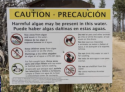
The warning sign at Devil's Gulch trailhead/Hites Cove (taken from the San Francisco Chronicle article posted earlier.) Remote hiking area where Northern California family was found dead treated as a hazmat site
Yeah & this warning sign posted about the area says you can SWIM in the water—just don’t mess with the algae. So swimming or wading through shouldn’t kill you.Wouldn't they be vomitting in case the toxic algae was the cause of the death? Besides, it seems to be doubtful they would have died so soon and simultaneously.
Annihilation seems to be quite possible. Anyway, poor baby was their daughter, just beginning to live.
IMO

Heat Stroke in Dogs
It is important to remember that dogs cannot control their body temperature by sweating as humans do since they only have a relatively small number of sweat glands located in their footpads. Their primary way of regulating body temperature is by panting.
Other common causes of heat stroke include being left in a yard without access to shade or water on a hot day, being exposed to a hair dryer for an extended period of time, and excessive or vigorous exercise during hot temperatures. Excited or excessively exercised dogs are sometimes at risk even if the environmental temperature and humidity does not seem high
We just don't know. Also the car keys. Were they with them.Good thought, also nothing has been mentioned about cell phones, were they found with them on the trail? Had they taken pictures on the hike, tried to call out, send a text message? That might sound strange, but if one of them was in distress and the others started failing I could see trying to leave a clue even though there was no signal. But if overtaken quickly, I guess there would be no time or clarity of thinking.
Young ones cannot regulate their temperature like children or adults.Years ago I was at Mammoth going up a trail when there was a large group of people coming down in a rush. It was a Sunday and they had spent the weekend camping around one of the mountain lakes (not the Mammoth Lakes.) One of the women was carrying a limp baby girl about a year old, mother said that she was suffering from heat exhaustion (and probably altitude sickness). Father carried the two backpacks. It was 89 but because of the altitude one is closer to the sun so it feels even hotter.
I realize altitude was not a problem here.
True, MI’s wouldn’t be obvious on physical exam, but troponin is still present post-mortem and that’s a quick blood test (they do it all the time for patients complaining of chest pain, we don’t wait 6 weeks to give them their trop values!).I am still leaning towards a situation that created cardiac arrhythmias in them all. You won't necessarily see this in an immediate autopsy. And there might not be external markers. Electrical current or toxins. If they ran their water through a filter, it doesn't mean they eliminated certain toxins. They were all found dead, but might have died in short intervals after being incapacitated as well.