Edited to resize and reattach the pic because it was too large to upload.
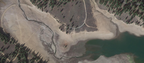
Below is a sat image (Google Earth image) that I believe is from the boat launch when they first began searching. I cannot confirm the date it was shot (it says unavailable), but I am assuming this would have been from early in the searc when we know they were focused on the boat launch.
Of course, it could be from any other date that there were what appear to be (MOO) LE personnel and vehicles in the boat ramp and one vehicle in the nearby parking lot.
I cannot 100% substantiate that this image is from that day, but it is a possibility.
I used Google earth to view the area and all surrounds, including the path Kiely would have traveled all the way to her home, but again, you are correct that I can’t state with 100% certainty the date that GE last captured the area.
Now, you might say, if it was from early on in the search, why weren’t there more vehicles looking? By all accounts, there were not legions of folks out there looking for her after the first 2 days early on, at least aas reported by folks out there searching (Steve Fisher addressed this on Twitter but not sure if I am allowed to link to such tweets of his).
I can’t link to Google Earth, but you can download the app or search there to see what I see there.
View attachment 361745


") And... it's temporary and gets you where you're going without having to stagger... errr... I mean walk.
And... it's temporary and gets you where you're going without having to stagger... errr... I mean walk. 