PK most likely did not have a map because none are available at the Moller staging area. The Moller staging area is not a legal access point to Pleasanton Ridge so there is no signage from EBRPD. The rangers will tell you that you can be cited and fined for taking one of the many trails from Moller to PR. PK could have easily been lost on the trails but they all eventually lead to one of two PR access roads. If PK did make it to PR he had to pass at least 3 no entry signs and through cut barbed wire to reach PR. The water tanks on the grade up to PR are all sealed tanks.I was referring to the Aug 2019 route. I am not sure whether he ran clockwise in the east direction (North Ridge) or counterclockwise in the west direction (Cowing to Sinbad Creek) but on the EBRPD map https://www.ebparks.org/civicax/filebank/blobdload.aspx?BlobID=24388 , the only areas marked with W for drinking water above Augustin Bernal Park are on the east side of the park. The map I am looking at is on p. 2 and I assume it is up to date. The W that was closest is near the box that holds all of the tall antenna structures near the North Ridge trail. I don't know if Philip had a map with him or had looked at in detail prior to the run. But from the map, I don't know of any drinking water at the north end of the Pleasanton Ridge park or the west side trails at all. If it was a hot day, and if it were me, I would have maybe stuck to the side of the park with the drinking water which is at least as I can tell the east side. Or in the past when I have entered the park through Golden Eagle and gone through Augustin Bernal along shady trails and it is really hot up there, I've just turned around and gone back.


You are using an out of date browser. It may not display this or other websites correctly.
You should upgrade or use an alternative browser.
You should upgrade or use an alternative browser.
Found Deceased CA - Philip Kreycik, 37, Pleasanton Ridge Regional Park, 10 Jul 2021
- Thread starter mlhenn
- Start date
- Status
- Not open for further replies.
- Joined
- Jul 30, 2021
- Messages
- 51
- Reaction score
- 1,004
PK most likely did not have a map because none are available at the Moller staging area. The Moller staging area is not a legal access point to Pleasanton Ridge so there is no signage from EBRPD. The rangers will tell you that you can be cited and fined for taking one of the many trails from Moller to PR. PK could have easily been lost on the trails but they all eventually lead to one of two PR access roads. If PK did make it to PR he had to pass at least 3 no entry signs and through cut barbed wire to reach PR. The water tanks on the grade up to PR are all sealed tanks.
you take a legal trail to a closed fire road in the park. You have one gate to go around and one gate to hop. Only the one gate you go around is going to say the area is closed, but since it specifies it’s park land it’s one of those things most folks ignore.
@runspired welcome to Websleuths!! Hope you become a verified insider soon!
Good luck in finding Philip!
Good luck in finding Philip!
- Joined
- Jun 27, 2019
- Messages
- 15,992
- Reaction score
- 206,778
PK most likely did not have a map because none are available at the Moller staging area. The Moller staging area is not a legal access point to Pleasanton Ridge so there is no signage from EBRPD. The rangers will tell you that you can be cited and fined for taking one of the many trails from Moller to PR. PK could have easily been lost on the trails but they all eventually lead to one of two PR access roads. If PK did make it to PR he had to pass at least 3 no entry signs and through cut barbed wire to reach PR. The water tanks on the grade up to PR are all sealed tanks.
Thank you for this detailed description. The situation has been described here before, not in as much detail.
It's still mystifying what happened. Even if he got lost, it seems to me there are enough access roads that he would have found his way back within hours.
I do wonder if locals are taking a dim view of the trespassing issue.
Also, thank you, @Emi for the video. I feel so badly for his family. There have been way too many missing people who were solo hiking/running, this year (and where I live, there have been so many SAR call-outs for the nearby mountains in L.A. - often heat related).
People think that they can conquer heat, but every human body will eventually have a very poor reaction to high temperatures (and weather reports give the temps in the shade - it's often much hotter in the sun, on ridges, or in narrow canyons). Eventually the human body will rise to the ambient temperature if a person is out long enough. I'm not saying that's what happened to Phil, but moderate heat exhaustion can cause cognitive issues...
- Joined
- Jul 30, 2021
- Messages
- 51
- Reaction score
- 1,004
I did send in the VI, so hopefully soon.@runspired welcome to Websleuths!! Hope you become a verified insider soon!
Good luck in finding Philip!
- Joined
- Jan 17, 2018
- Messages
- 4,495
- Reaction score
- 42,205
I did send in the VI, so hopefully soon.
Until you are verified, may I suggest that with each post, you clearly state as your opinion ("IMO" or"MOO" etc) any comments you make that are not supported by links to media articles or PK's social media. It's how Websleuths is set up and what keeps it a truth-based site.
Just to make sure your posts are permitted to stand in the meantime.
- Joined
- Jan 23, 2019
- Messages
- 3,658
- Reaction score
- 21,208
Is there any BLM land relatively nearby or places a person who was experienced at being outdoors could hide out for a bit if they felt overwhelmed and needed to get away for awhile?
I'm just thinking about the unaccounted for time in the morning and wondering if PK could have stashed some gear, picked it up and headed out someplace in nature to literally get away from it all?
I realize none of this fits with his character as shown, but as we all know and has been acknowledged in this thread, it has been a rough year+ for everyone, and anyone can have personal struggles.
- Joined
- Jan 23, 2019
- Messages
- 3,658
- Reaction score
- 21,208
- Joined
- Jul 11, 2019
- Messages
- 20,693
- Reaction score
- 88,211
Can anybody read the linked article for us who don’t have a subscription? There’s a paywall w/ article.
- Joined
- Jan 7, 2015
- Messages
- 2,195
- Reaction score
- 14,909
Can anybody read the linked article for us who don’t have a subscription? There’s a paywall w/ article.
I don't think it is behind a paywall, I could read it. In the UK too, so major surprised. Anyway not much new, but
"The Pleasanton Police Department and Alameda County Sheriff’s Office will send out search teams for Kreycik Saturday in a final push to find him, said Sergeant Ray Kelly with the Alameda County Sheriff’s Office.
Kelly said search teams will focus on the deep ravines, creek beds and water runoff areas in Pleasanton Ridge Regional Park Saturday morning"
Pleasanton PD @pleasantonpd 4h
It's been nearly 3 wks since Philip Kreycik was reported missing after he failed to return from a run at #Pleasanton Ridge. The search & investigation continues as @ACSOSheriffs search teams are set to deploy tomorrow. We'll provide an update after the search is complete.


It's been nearly 3 wks since Philip Kreycik was reported missing after he failed to return from a run at #Pleasanton Ridge. The search & investigation continues as @ACSOSheriffs search teams are set to deploy tomorrow. We'll provide an update after the search is complete.
- Joined
- Jan 23, 2019
- Messages
- 3,658
- Reaction score
- 21,208
Can anybody read the linked article for us who don’t have a subscription? There’s a paywall w/ article.
I will PM it to you. It is short
I think it means we’ve read too many articles and have gone over our monthly “free” limit with the SF Chronicle. I’m blocked, too.Can anybody read the linked article for us who don’t have a subscription? There’s a paywall w/ article.
- Joined
- Jun 27, 2019
- Messages
- 15,992
- Reaction score
- 206,778
maybe www.sfgate.com will have the article (it's the free version of the Chronicle).
Log into Facebook
Pleasanton Police Department 5h
It's been nearly three weeks since Berkeley resident, Philip Kreycik, was first reported missing after he failed to return from a run at Pleasanton Ridge Regional Park. Early on, dozens of agencies from across California conducted a large-scale search and rescue effort for several days to no avail.
Though efforts have scaled back, both the search and investigation remain underway. Alongside Alameda County Sheriff's Office, search teams are set to deploy once more. Tomorrow, members will return to where Philip intended to run and comb select areas in hopes of bringing him home. We will provide an update after the search is complete.
Anyone with information about this case may submit a tip by calling (925) 931-5107 or e-mail [email protected].
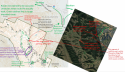
@runspired @ElizabethAnne please check this combination of the EBPRD Map and Google Map for accuracy.I did send in the VI, so hopefully soon.
EBRPD - Pleasanton Ridge
Google Maps
The most important clue seems to be whether the footprints were his showing him climbing the Mariposa Trail. It seems the match could have been made without physically having his shoes if imprints were collected or photographed from the July 9 run or a previous run when he wore the same shoes. Like @ElizabethAnne pointed out the Strava route shows a descent and so clockwise route on the loop. If PK was ascending then he made a counter-clockwise loop. If he made Mariposa Trail then the most likely problem he would encounter is the descent from PR back to the Staging Area after the end of the at least 12' wide fire road. Choosing Moller Ranch Staging Area for his run made sense because it is the closest starting point for Pleasanton Ridge getting off the freeway from 580 coming from Berkeley and then getting right back on 580 to go to Stockton.
Attachments

- Joined
- Jan 23, 2019
- Messages
- 3,658
- Reaction score
- 21,208
Forgive me if this is naive, but do you need PK's actual shoes here? the prints do not seem to show any unusual wear pattern, so would it not be possible to backtrack to hopefully determine the exact shoe (i.e.if he purchased them online), and confirm via Saucony or something like going to a store and taking a photo of the same shoe?
Would this not get you "close enough"? Obviously if he wears a size 11, that is pretty common, and Saucony is pretty common, but at least for the prints to likely be his?
Would this not get you "close enough"? Obviously if he wears a size 11, that is pretty common, and Saucony is pretty common, but at least for the prints to likely be his?
- Joined
- Nov 16, 2019
- Messages
- 55
- Reaction score
- 455
Im curious if even his family is considering he might not be at the park and going with the highly implausible theory that he is being nursed back to health by a Good Samaritan that doesn’t watch the news, because cadaver dogs have not picked up a scent.
- Joined
- Jul 30, 2021
- Messages
- 51
- Reaction score
- 1,004
@runspired @ElizabethAnne please check this combination of the EBPRD Map and Google Map for accuracy.
EBRPD - Pleasanton Ridge
Google Maps
The most important clue seems to be whether the footprints were his showing him climbing the Mariposa Trail. It seems the match could have been made without physically having his shoes if imprints were collected or photographed from the July 9 run or a previous run when he wore the same shoes. Like @ElizabethAnne pointed out the Strava route shows a descent and so clockwise route on the loop. If PK was ascending then he made a counter-clockwise loop. If he made Mariposa Trail then the most likely problem he would encounter is the descent from PR back to the Staging Area after the end of the at least 12' wide fire road. Choosing Moller Ranch Staging Area for his run made sense because it is the closest starting point for Pleasanton Ridge getting off the freeway from 580 coming from Berkeley and then getting right back on 580 to go to Stockton.
View attachment 306609
The Strava route this uses seems to be a mish-mash of the 2019 route with the 2021 route start, not his 2021 route that he drew either late the night before or morning-of.
The 2021 route is counter-clockwise, and has him ascending Turtle Pond Trail. It's private, though I can try to get it made public. The assumption (even day of) was that this was slightly too far for his time budget and he'd either converted to an out-and-back or short-cutted via Mariposa (where he would have been going uphill).
There are actually two locations of prints, one near the bottom of Mariposa trail (photographed by Scott) and one near the middle (photographed by me). The fact it's a full-print and not a partial-print despite the grade in that section being fairly low suggests he was power-hiking (at least) and not running, which is uncharacteristic of his style and suggests he was at that point dialing way back due to the heat (if not already in trouble).
- Joined
- May 9, 2009
- Messages
- 43,126
- Reaction score
- 219,152
ADMIN NOTE:
WS member, runspired, has now been Verified as a case insider in Philip's case. We'll let them explain their relationship to Philip and this case.
As a VI, runspired is not required to provide links to support their knowledge of the case. Please treat our VI with respect at all times, i.e. no personalizing, bickering or challenging them on whatever input they provide. It is fine to ask questions, but they do not have to respond. If that's the case, just move on without badgering them for info.
As promised, runspired's initial post has been reinstated along with responses that were removed.
Welcome and Thank You to runspired and all others for caring and being here to discuss Philip's mysterious disappearance.
Last edited:
- Status
- Not open for further replies.
Similar threads
- Replies
- 461
- Views
- 107K
- Locked
- Replies
- 426
- Views
- 70K
- Locked
- Replies
- 1,080
- Views
- 163K
Guardians Monthly Goal

Goal Reached! We hit our target of 75 new Guardians!
New stretch goal: 100!
Our goal for the month is 75 new Guardians members to sign up. Have you been thinking about becoming a member?
Click here to find out how!
Online statistics
- Members online
- 63
- Guests online
- 1,061
- Total visitors
- 1,124
Totals may include hidden visitors.
Forum statistics
Community Rules
-
Be CivilTreat all members with respect. No personal attacks, harassment, or inflammatory language.
-
Victim FriendlyAlways show respect for victims and their families. No victim blaming or insensitive speculation.
-
Fact-based SourcingProvide credible sources for claims. Distinguish between verified facts and personal theories.
-
Social Media UseDo not post direct links to personal social media profiles of private individuals.
-
Copyright and PaywallsDo not copy full articles. Summarize and link to the original source instead.
-
Privacy and Personal InformationDo not post personal information such as addresses, phone numbers, or workplaces.
-
Registered Sex-OffendersDo not name or speculate about RSOs unless officially named in connection to a case.
-
Stay On TopicKeep discussions relevant to the case or topic at hand. Avoid off-topic tangents.
-
Accounts, Moderation, and DisputesOne account per person. Contact moderators privately for disputes or concerns.
-
Solicitation and FundraisingNo solicitation, fundraising, or promotion of personal ventures without approval.