

You are using an out of date browser. It may not display this or other websites correctly.
You should upgrade or use an alternative browser.
You should upgrade or use an alternative browser.
Found Deceased CO - Suzanne Morphew, 49, did not return from bike ride, Chaffee County, 10 May 2020 #44
- Thread starter Mysti88c
- Start date
- Status
- Not open for further replies.
- Joined
- Jun 7, 2016
- Messages
- 3,115
- Reaction score
- 49,752
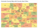
For reference: (I found it helpful to see on a map while we wait for the Seguache County results).
Colorado County Map
Colorado County Map
Attachments
Maybe there's a Bobcat Camper attachment.
Didn't people all over the world do that when flight MH370 went down in 2014? I remember seeing people submitting satellite screenshots of areas of the south Indian Ocean highlighting what looked like a plane's remains.
I participated in that search, which was sponsored by a now defunct Denver company called TOMNOD. The undertaking was enormous. The original intention was to search the south Indian Ocean area where the plane last had communication, but expanded to a huge swath of the globe from India to Antarctica. Each of the hundreds of thousands of searchers signed on, was assigned a general area that was being searched, and could choose from a grid of hundreds of large squares of satellite imagery. Those grid squares were in turn divided divided into smaller squares. The searcher clicked on one square, and began visually searching. I could identify a fishing vessel on the water, but could not say whether it was a forty foot or a 60 foot trawler. The most excitement came with the sighting of a plane of similar shape to MH370, but was actually a much smaller airliner, that had just lifted off from a Burmese airport and appeared to me to be skimming the jungle treetops. Nevertheless, I signaled a significant "hit" simply because I figured someone with more knowledge could make that determination better than myself. It appeared to many thousands of other searchers as being nestled among the trees. The extensive underwater sonar searches by the Australian government did not use Tomnod information, but relied on flight path calculations discovered on the hard drive of the pilot's home cockpit simulator. When debris finally washed up on African shores a year later, it soon became obvious that the debris had floated on the surface for an extensive distance searched by Tomnod crowd sourcing. Much of that debris path had been photographed in black and white, when it turned out the highest probability of a sighting might have been a glint of color, perhaps even a single pixel, on a dark sea. The idea was great in principle; but the satellite technology was simply not yet refined enough to do searches for individuals or even relatively large objects, and the search system itself was very repetitive and downright boring which was apparently the primary cause of so many false sightings by so many searchers. TOMNOD followed with several smaller scale searches over land mass, and discovered that when part of the landscape was interesting and part of it was not, the interesting sections were searched by way more people than needed, while the boring parts never did get searched. Ultimately, it was quietly discontinued and the company dissolved. IMO
- Joined
- Nov 9, 2015
- Messages
- 5,121
- Reaction score
- 47,880
Thank you, branmuffin, for the Chaffee County list of mines.
Do you believe LE and/ or AM have visited the 3 mines near Maysville in their search for SM?
I hope they have already cleared those 3 and are then checking mines near Salida.
I wish I was 40 years younger...footloose and fancy free....able to be physically involved in searching the Chaffee County mines.
Where are you, SM?
MOO
There is a mine very close to the M residence. I hoped they searched that mine, at least.
- Joined
- Feb 27, 2005
- Messages
- 3,868
- Reaction score
- 21,692
Having a Bobcat on-hand, loaded up and ready for transport to where ever and when ever at a moment's notice... must be quite comforting to a someone who might eventually feel urgent need to dig up and move something.
- Joined
- May 5, 2009
- Messages
- 8,653
- Reaction score
- 61,406
Wondering this morning if BM had access to a horse somewhere.
That would really get him off the grid for hours.
That would really get him off the grid for hours.
There is a mine very close to the M residence. I hoped they searched that mine, at least.
The one that is northwest of Puma Path is a developmental mine. That means there has been very little actual work, other than ore sampling. A searcher could probably walk right through it and not know they had. However, in a comprehensive mine search, more investigation would seemingly be required before ruling it out as a possibility.
I posted in a previous thread that there is a large scale former mine just north of Maysville, which closed too long ago to be listed in current mine operations, has no further mineral extraction value, and exists only as "historic".
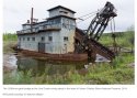
The remaining evidence is a series of stair-stepped ponds linking what once was a creek bed, which I had Google Earth outline in yellow. The type of mining in this instance was dredge mining.
The first picture is a National Park Service photo of an ore dredge in the famous Yukon gold fields, which would be similar to the machine that created the ponds near Maysville. Such a dredge would have been assembled at the top left of the yellow box in the second picture, a Google Earth aerial view. Once operational, the dredge literally scooped out alluvial rock ahead of itself, crushed it, filtered out the heavier ore in a series of internal sluices, and deposited the tailing behind it in a series of ponds and dams designed to provide a constant source of water. It is an extremely slow process. My guess is that it took ten to fifteen years to work the 1.5 miles down to below the last pond. The area to the north and west of the yellow box is currently under mining claims, but has never been worked. The modern method of blasting, gathering and heap leaching is not likely to be approved under today's far more protective mining laws, so that area may remain just claims for many decades more.
This illustrates very well that those hundreds of mines listed come in all shapes and sizes..........just identifying them to determine how to search or even if a search is needed is a formidable task.
IMO
Rust in the Wilderness: The Story of Mining Machines in Yukon-Charley Rivers National Preserve (U.S. National Park Service)
Maysville photos are Google Earth shots with no external editing. Dredge photo by US National Park Service
Attachments
Last edited:
Willowwood26
Well-Known Member
- Joined
- Mar 3, 2020
- Messages
- 60
- Reaction score
- 877
@Dave F. May I ask what your background is? You have a such wide field of knowledge. Thank you.The one that is northwest of Puma Path is a developmental mine.
Maysville photos are Google Earth shots with no external editing. Dredge photo by US National Park Service
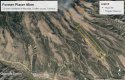
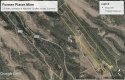
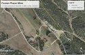
I was just studying one of the 473 mines in Saguache county, called Allara Tunnel mine. It's located about ten miles southeast of the tiny village of Cathedral, in Hinsdale county, but Allara Tunnel is in Saguache county. To get to it from Cathedral, a search party would have to drive south 2 miles to a point on CR 8 EE where a rocky two track trail begins, and follow that trail 8 miles. The thin green line from top to bottom of the first aerial shot is the county line between Hinsdale, on the left; and Saguache, on the right.They could drive in an older Jeep or Ford Ranger compact 4 wheel drive pickup, but it would be much easier to just hike. I certainly would not attempt it in darkness. The hike is about a 975 foot vertical elevation rise, between 9,225 ft and 10,200. There's some old mine buildings there, but they have apparently been locked up since 1971, so there's probably no shelter and at 10,200 feet, it gets pretty darn cold at night, even in July.
I rotated Google Earth around and zoomed down low so the actual mine could be seen. It looks like it was an exploratory adit/shaft. The adit, which is the horizontal part, is probably only about 4 feet high but it looks like it at least three feet wide, possibly four. There's no way to guess how many shafts went upward off of it, but probably not too many. You can see all of the tailings in the aerial shot, and it's not a great amount. Having not been worked since 1970, it probably has some surprise water issues and maybe a few cave-ins. I would let someone else actually go in the mine. I was in the mining business, and places like that give me the squirrelly heebie jeebies.
I was looking at it because it fits the meager description provided in the news reports of the remains found. That mountain marked just west of the mine is named Mineral Mountain. If you started hiking from the south and took several days, a person could bag three fourteeners on conventional trails, and then use a map, GPS and a compass to hike some pretty high pass country and come down to this mine. I can't believe there is any cell phone service anywhere close to this place.
All in all, it wouldn't be easy, and a searcher would have to do a lot of land research to make sure there was written permission to be there, but a search of this place would be doable, I think.
IMO
Both images produced entirely in Google Earth Pro with no external editing. The coordinates of the mine were copied and pasted from:
Saguache County, Colorado Mines
This is very helpful for us "flatlanders" in the Midwest. While I academically know that Colorado has mines, I was unaware of the sheer number of abandoned mines out there. I would think that said locations could be excellent hiding places for a body, provided a person could get the body there in the first place.
Colorado does have a lot of places in which to hide a body, but I think BM did not go very far with SUZANNE. I also think he wasn’t all that creative with where he put her.
And if he isn’t a serial killer, or used to handling dead bodies, I feel he would want to rid himself of her ASAP.
It occurred to me this morning that maybe one reason a firm timeline has never been made public by LE is because it does lock BM into a very finite area in which he could have hidden SUZANNE, and they are methodically searching within that area? Maybe?
I do think margarita25’s (I think?) idea about Reverse Rossmo(?) has a lot of merit. Or at least, graphing information from other familial murderers, and where and how far from home they buried their victims. (Yes, I know, a very time-consuming task, to say the least.)
But I think most humans have within them a spatial sense that is hard-wired, and we may act or select based on subconscious criteria—like an innate triangulation or the Fibonacci Sequence or the Golden Ratio.
As a former mapmaker ( I was a computer-aided drafter for many years), the idea of creating a visual “Murder Victims’ Map” based on actual facts that could help disseminate cases of the missing is kind of exciting.
And even as I say that, I’m assuming such a map has been developed already by LE or someone, somewhere?
Having a Bobcat on-hand, loaded up and ready for transport to where ever and when ever at a moment's notice... must be quite comforting to a someone who might eventually feel urgent need to dig up and move something.
This has crossed my mind, if BM buried or hid SUZANNE in a large cooler, she could possibly be moved from place to place.
- Joined
- May 17, 2009
- Messages
- 36,322
- Reaction score
- 345,478
Andy spoke of his experience searching a mine while he was in Colorado, IIRC he lost his source of light and said how scary it was getting out. Thanks for posting this!I'm posting this at random. Searching abandoned mines is extremely dangerous. Searchers who do this are trained in Cave Mine Rescue. It requires special equipment and at least three sources of light. For those who still chose to explore or search, leave a note detailing exactly what cave or mine you will be at, what entrance point you are going in at and what time you expect to be back. Never, ever go alone. Take food, water, three sources of light and extra batteries and warm clothing. Ceiling and wall collapse (cave in) is an ever present danger as is toxic gas, and in some cases, radiation. The safest way to explore is to used a tethered camera down a vent shaft, a remote vehicle or a drone. Remember, we are all only one poor decision away from being the subject of a WS missing person thread.
- Joined
- May 17, 2009
- Messages
- 36,322
- Reaction score
- 345,478
Me too. I was thinking last night, with the search over will we ever receive updates from CCSO or the CBI? Lauren really kept the spotlight shining, I'm afraid without her this case will go silent.I’m hoping we get some type of additional info or clarification on the timeline this week. Seems doubtful that will happen but it sure would be nice.
I participated in that search, which was sponsored by a now defunct Denver company called TOMNOD. The undertaking was enormous. The original intention was to search the south Indian Ocean area where the plane last had communication, but expanded to a huge swath of the globe from India to Antarctica. Each of the hundreds of thousands of searchers signed on, was assigned a general area that was being searched, and could choose from a grid of hundreds of large squares of satellite imagery. Those grid squares were in turn divided divided into smaller squares. The searcher clicked on one square, and began visually searching. I could identify a fishing vessel on the water, but could not say whether it was a forty foot or a 60 foot trawler. The most excitement came with the sighting of a plane of similar shape to MH370, but was actually a much smaller airliner, that had just lifted off from a Burmese airport and appeared to me to be skimming the jungle treetops. Nevertheless, I signaled a significant "hit" simply because I figured someone with more knowledge could make that determination better than myself. It appeared to many thousands of other searchers as being nestled among the trees. The extensive underwater sonar searches by the Australian government did not use Tomnod information, but relied on flight path calculations discovered on the hard drive of the pilot's home cockpit simulator. When debris finally washed up on African shores a year later, it soon became obvious that the debris had floated on the surface for an extensive distance searched by Tomnod crowd sourcing. Much of that debris path had been photographed in black and white, when it turned out the highest probability of a sighting might have been a glint of color, perhaps even a single pixel, on a dark sea. The idea was great in principle; but the satellite technology was simply not yet refined enough to do searches for individuals or even relatively large objects, and the search system itself was very repetitive and downright boring which was apparently the primary cause of so many false sightings by so many searchers. TOMNOD followed with several smaller scale searches over land mass, and discovered that when part of the landscape was interesting and part of it was not, the interesting sections were searched by way more people than needed, while the boring parts never did get searched. Ultimately, it was quietly discontinued and the company dissolved. IMO
Interesting info. I recall you posting some of this early on in the thread. My daughter is a SAR (Search & Rescue) pilot. She reports that when searching for boats/people on the water, her team flies up at first light (sun at shallow angle and water "smooth") to patrol. Color doesn't help detect points of interest as much as disruptions to the water surface do.
- Joined
- Dec 1, 2008
- Messages
- 17,975
- Reaction score
- 172,789
I don’t think they will release anything they apparently don’t need the public’s helpI’m hoping we get some type of additional info or clarification on the timeline this week. Seems doubtful that will happen but it sure would be nice.
JMO
- Joined
- Feb 25, 2013
- Messages
- 46,292
- Reaction score
- 479,366
Nope. Not true.Yeah, I also skipped the 877 mines in Gunnison county and the 365 in Hinsdale county, too. @Seattle1 told me I was unnecessarily expanding the issue, so I did my best to scale back. Hope I didn't mislead anyone. IMO
Gunnison County, Colorado Mines
Hinsdale County, Colorado Mines
CemeteryHunter12
Well-Known Member
- Joined
- Oct 1, 2020
- Messages
- 47
- Reaction score
- 568
Colorado does have a lot of places in which to hide a body, but I think BM did not go very far with SUZANNE. I also think he wasn’t all that creative with where he put her.
And if he isn’t a serial killer, or used to handling dead bodies, I feel he would want to rid himself of her ASAP.
It occurred to me this morning that maybe one reason a firm timeline has never been made public by LE is because it does lock BM into a very finite area in which he could have hidden SUZANNE, and they are methodically searching within that area? Maybe?
I do think margarita25’s (I think?) idea about Reverse Rossmo(?) has a lot of merit. Or at least, graphing information from other familial murderers, and where and how far from home they buried their victims. (Yes, I know, a very time-consuming task, to say the least.)
But I think most humans have within them a spatial sense that is hard-wired, and we may act or select based on subconscious criteria—like an innate triangulation or the Fibonacci Sequence or the Golden Ratio.
As a former mapmaker ( I was a computer-aided drafter for many years), the idea of creating a visual “Murder Victims’ Map” based on actual facts that could help disseminate cases of the missing is kind of exciting.
And even as I say that, I’m assuming such a map has been developed already by LE or someone, somewhere?
This has crossed my mind, if BM buried or hid SUZANNE in a large cooler, she could possibly be moved from place to place.
Bolded this to ask...wouldn't the smell be awful?
- Joined
- Sep 21, 2020
- Messages
- 5
- Reaction score
- 163
In regards to the PYMK showing up on someone's fb. Usually if someone looks at your profile who isn't your fb friend their profile will show up in your PYMK if the person doesn't send you a friend request. (Hope that makes sense).
So if whoever was on SM facebook looking at profiles SM's profile would have showed up in their PYMK.
So maybe whoever was on SM's facebook looked at a few profiles before sending any of the friend requests. IMO.
This is my first post so I hope I done it right.
So if whoever was on SM facebook looking at profiles SM's profile would have showed up in their PYMK.
So maybe whoever was on SM's facebook looked at a few profiles before sending any of the friend requests. IMO.
This is my first post so I hope I done it right.
- Joined
- May 24, 2020
- Messages
- 1,238
- Reaction score
- 24,854
In the recently aired DR. Phil he asks AM:
Beginning at 3:26
Would she go off the radar for seven days?
and no social media presence ?
No presence electronically for that amount of time?
Is this new information? Interesting questions.
Beginning at 3:26
Would she go off the radar for seven days?
and no social media presence ?
No presence electronically for that amount of time?
Is this new information? Interesting questions.
In regards to the PYMK showing up on someone's fb. Usually if someone looks at your profile who isn't your fb friend their profile will show up in your PYMK if the person doesn't send you a friend request. (Hope that makes sense).
So if whoever was on SM facebook looking at profiles SM's profile would have showed up in their PYMK.
So maybe whoever was on SM's facebook looked at a few profiles before sending any of the friend requests. IMO.
This is my first post so I hope I done it right.
You did great!
Welcome to WS.
Hope you stay awhile!
- Joined
- May 21, 2013
- Messages
- 20,671
- Reaction score
- 240,153
In the recently aired DR. Phil he asks AM:
Beginning at 3:26
Would she go off the radar for seven days?
and no social media presence ?
No presence electronically for that amount of time?
Is this new information? Interesting questions.
I haven't been able to watch this, but what was the 7 day reference about? This is the first I'm hearing this.
- Status
- Not open for further replies.
Similar threads
- Locked
- Replies
- 1,001
- Views
- 164K
- Locked
- Replies
- 1,024
- Views
- 188K
- Locked
- Replies
- 937
- Views
- 155K
- Locked
- Replies
- 1,036
- Views
- 170K
- Locked
- Replies
- 1,053
- Views
- 155K
Guardians Monthly Goal

Goal Reached! We hit our target of 75 new Guardians!
New stretch goal: 100!
Our goal for the month is 75 new Guardians members to sign up. Have you been thinking about becoming a member?
Click here to find out how!
Online statistics
- Members online
- 98
- Guests online
- 2,440
- Total visitors
- 2,538
Totals may include hidden visitors.
Forum statistics
Community Rules
-
Be CivilTreat all members with respect. No personal attacks, harassment, or inflammatory language.
-
Victim FriendlyAlways show respect for victims and their families. No victim blaming or insensitive speculation.
-
Fact-based SourcingProvide credible sources for claims. Distinguish between verified facts and personal theories.
-
Social Media UseDo not post direct links to personal social media profiles of private individuals.
-
Copyright and PaywallsDo not copy full articles. Summarize and link to the original source instead.
-
Privacy and Personal InformationDo not post personal information such as addresses, phone numbers, or workplaces.
-
Registered Sex-OffendersDo not name or speculate about RSOs unless officially named in connection to a case.
-
Stay On TopicKeep discussions relevant to the case or topic at hand. Avoid off-topic tangents.
-
Accounts, Moderation, and DisputesOne account per person. Contact moderators privately for disputes or concerns.
-
Solicitation and FundraisingNo solicitation, fundraising, or promotion of personal ventures without approval.