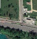
This "gap" other posters have noticed in the median between the east- and west-bound lanes near the crash site does line up with the area where the car was found.
View attachment 179453
But, (assuming they turned the wrong way off of Hwy 7), would they have been driving on the west-bound lane of the highway, or the side road, at that point?
There is also another turn-around spot shown in a NEWS4 article posted earlier today, a video report showing the path police believe they may have taken. It starts with the couple turning west off of Highway 7 (away from the airport) and doing a U-turn beyond (further west) of the wreck site. Something like this red line drawn by me:
View attachment 179450
The problem with both of these proposed turn around spots is that when turning west off of Hwy 7, it looks like you enter a small road (Marginal Avenida Las Américas) running parallel to the main interstate-like road (Autopista Las Américas). It is unclear from the Google satellite image whether there is an actual barrier between this side road and the west-bound lane of the "Autopista." I don't see obvious tire tracks between them either, unlike the multiple tracks seen in the dirt median between the main east and west bound lanes at this spot. So if they went west on the "Marginal" road, it looks like the first opportunity to enter the main road was in the area indicated in my map above, and in detail here:
View attachment 179452
But... This would still have put them in the east-bound Autopista lane with no visible way to get over to the west bound side, unless they drove the wrong way unto they reached the barrier gap noticed by other posters.


