

You are using an out of date browser. It may not display this or other websites correctly.
You should upgrade or use an alternative browser.
You should upgrade or use an alternative browser.
Hurricane Laura - August 2020
- Thread starter Lato
- Start date
Gardenista
Well-Known Member
- Joined
- Jun 21, 2016
- Messages
- 19,034
- Reaction score
- 182,275
The friend I mentioned earlier told me her youngest sister and husband are staying. They live in Lake Charles. She's beyond herself with worry.With previous hurricanes projected to hit Florida, I could go into my "Google driving map" and see red lines on interstates with folks evacuating. I just opened it up and looked at the Lake Charles area as my center point.... no red at all. All green with some road closures. There was no red this am either.
Strange.

Gardenista
Well-Known Member
- Joined
- Jun 21, 2016
- Messages
- 19,034
- Reaction score
- 182,275
Going to make landfall at high tide
Mike's Weather Page
12m ·
5pm CDT NHC update. High tide coming in close to landfall. Laura currently a Category 4 with 145mph winds. Expected to increase to 150mph by landfall overnight near the TX/LA state line. www.spaghettimodels.com
Mike's Weather Page
12m ·
5pm CDT NHC update. High tide coming in close to landfall. Laura currently a Category 4 with 145mph winds. Expected to increase to 150mph by landfall overnight near the TX/LA state line. www.spaghettimodels.com
I'm so worried for you. I admire you for caring so much for your animals. I understand that completely. Stay as safe as you can please.Wish we could sha. 14 cats &. 2 dogs one of which is a pit. Can’t do it. We do have an attic & the DA, city attorney & judges live on our street. They’re staying. Our street will be first to loot.
Gardenista
Well-Known Member
- Joined
- Jun 21, 2016
- Messages
- 19,034
- Reaction score
- 182,275
This video is kind of nuts
https://twitter.com/TheAstroNick/status/1298721314706923523
https://twitter.com/TheAstroNick
Kermit (#NOAA42) flew through Hurricane #Laura FIVE times today. Here's a time lapse of our second pass up through the beginning for our third. A pass in and out of a hurricane is called a "penetration" or a "penny". Five pennies today takes my career total to 61
- Joined
- Jul 3, 2017
- Messages
- 7,523
- Reaction score
- 92,540
Thinking of everyone in harm's way. It's going to be very bad I fear. Please all, stay as safe as possible.
Catastrophic wildfires here, hurricanes there...what's next.....earthquakes?
Catastrophic wildfires here, hurricanes there...what's next.....earthquakes?
Tide charts ... Here's one that shows high tide at 12:19 a.m. in Cameron Parrish in Louisiana. That's around the time Laura's predicted landfall.
Website: Cameron Parish Tide Times, Tides Forecast, Fishing Time and Tide Charts Today - Louisiana - United States 2020
Image:

Website: Cameron Parish Tide Times, Tides Forecast, Fishing Time and Tide Charts Today - Louisiana - United States 2020
Image:
Gardenista
Well-Known Member
- Joined
- Jun 21, 2016
- Messages
- 19,034
- Reaction score
- 182,275
Lafourche Parish Sheriff’s Office @LafourcheSO
Here’s the current state of LA 1 below the Leon Theriot Lock in Golden Meadow. The highway remains closed and this area remains under a mandatory evacuation. #Laura


Here’s the current state of LA 1 below the Leon Theriot Lock in Golden Meadow. The highway remains closed and this area remains under a mandatory evacuation. #Laura
Gardenista
Well-Known Member
- Joined
- Jun 21, 2016
- Messages
- 19,034
- Reaction score
- 182,275
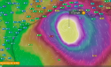
Levi Cowan @TropicalTidbits
New recon aircraft is measuring surface winds of 150-155 mph in the northeastern eyewall of Hurricane #Laura, very close to Category 5 intensity.

New recon aircraft is measuring surface winds of 150-155 mph in the northeastern eyewall of Hurricane #Laura, very close to Category 5 intensity.
Gardenista
Well-Known Member
- Joined
- Jun 21, 2016
- Messages
- 19,034
- Reaction score
- 182,275
Vermilion Parish Sheriff's Office
6h ·
MANDATORY EVACUATION
Effective immediately, the Vermilion Parish Police Jury has just ordered a Mandatory Evacuation for these areas.
If the storm maintains its current track and projected strength as a CAT 3 or 4, it will cause massive tidal flooding with a possible 12 to 18 foot surge and catastrophic wind damage to structures in Vermilion Parish creating a very dangerous situation to include loss of life. A curfew is in place beginning Wednesday, August 26, 2020 at 9:00 p.m. until 5:00 a.m. until further notice.
Evacuation for these areas are Mandatory:
• Pecan Island;
• Intracoastal City;
• Esther;
• Forked Island;
• Mouton Cove;
along with the following areas, South of La. Hwy. 14:
• Erath;
• Delcambre;
• Gueydan; and
• any low lying areas prone to flooding.
Those choosing to stay and face this very dangerous storm must understand that rescue efforts cannot and will not begin until after storm and surge has passed and it is safe to do so. Please evacuate and if you choose to stay and we can’t get to you, write your name, address, social security number and next of kin and put it a ziplock bag in your pocket. Praying that it does not come to this!
Expecting the worse but praying for the best.
Be Safe and God Bless!!
- Joined
- Dec 14, 2007
- Messages
- 16,172
- Reaction score
- 108,297
Me too!What’s your survival plan @Tony1902? Very worried about you!
Gardenista
Well-Known Member
- Joined
- Jun 21, 2016
- Messages
- 19,034
- Reaction score
- 182,275
Eric Fisher
@ericfisher
UPDATE brings peak winds to 150mph, pressure down to 940mb. #Laura is set to be the most powerful hurricane to strike southwestern Louisiana, dating to at least the 1850s. #wbz
@ericfisher
UPDATE brings peak winds to 150mph, pressure down to 940mb. #Laura is set to be the most powerful hurricane to strike southwestern Louisiana, dating to at least the 1850s. #wbz
- Joined
- Dec 14, 2007
- Messages
- 16,172
- Reaction score
- 108,297
And along with Covid. Maybe instead of Laura, it should be Hurricane Covid. :/Latest update. Video at the link
Tropical Tidbits
24m ·
Wednesday afternoon video update on Historic Hurricane #Laura, now hours from landfall in southwest Louisiana
“Unprecedented, historic event”
- Joined
- Feb 3, 2018
- Messages
- 20,794
- Reaction score
- 123,545
If there’s anyone left to rescue. More like scooping up floating bodies.
Louisiana Gov. Edwards calls Hurricane Laura 'huge threat to life,' storm may be worst since 1957
Louisiana Gov. Edwards calls Hurricane Laura 'huge threat to life,' storm may be worst since 1957
dixiegirl1035
I will do it, but I won't like it
- Joined
- Oct 5, 2017
- Messages
- 12,887
- Reaction score
- 107,203
- Joined
- Mar 17, 2009
- Messages
- 2,110
- Reaction score
- 8,302
In previous hurricanes, we had a roll call list for who is affected by awful storms. I know of @Tony1902 , others?
Be safe all!
Yes! Please let's do a roll call. This is so hard to watch and not be able to help from far away
Prayers going up!- Joined
- Feb 3, 2018
- Messages
- 20,794
- Reaction score
- 123,545
Similar threads
- Replies
- 194
- Views
- 14K
- Replies
- 304
- Views
- 26K
- Replies
- 7
- Views
- 2K
- Replies
- 450
- Views
- 29K
Guardians Monthly Goal

Goal Reached! We hit our target of 75 new Guardians!
New stretch goal: 100!
Our goal for the month is 75 new Guardians members to sign up. Have you been thinking about becoming a member?
Click here to find out how!
Online statistics
- Members online
- 93
- Guests online
- 1,715
- Total visitors
- 1,808
Totals may include hidden visitors.
Forum statistics
Community Rules
-
Be CivilTreat all members with respect. No personal attacks, harassment, or inflammatory language.
-
Victim FriendlyAlways show respect for victims and their families. No victim blaming or insensitive speculation.
-
Fact-based SourcingProvide credible sources for claims. Distinguish between verified facts and personal theories.
-
Social Media UseDo not post direct links to personal social media profiles of private individuals.
-
Copyright and PaywallsDo not copy full articles. Summarize and link to the original source instead.
-
Privacy and Personal InformationDo not post personal information such as addresses, phone numbers, or workplaces.
-
Registered Sex-OffendersDo not name or speculate about RSOs unless officially named in connection to a case.
-
Stay On TopicKeep discussions relevant to the case or topic at hand. Avoid off-topic tangents.
-
Accounts, Moderation, and DisputesOne account per person. Contact moderators privately for disputes or concerns.
-
Solicitation and FundraisingNo solicitation, fundraising, or promotion of personal ventures without approval.