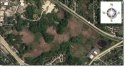
You can get a similar view from Google Maps with the Earth setting (and zoom in a bit more with less effort than the floodplain site). Included a screencap below.
The dark greens are trees and bushes. The light greens (to the southeast of the incident) are standing water with the surface covered in duckweed. The brown is mostly being referred to as 'swamp'. It is mostly cattails and other scrub plants. They can grow to probably 8 feet tall.
The default Google Map satellite view is from 2015, so is pretty recent/accurate. Looks to be mid-summer as the trees are all very green, without any browning that would come in the fall and into winter in this area. The swampy areas are usually not standing water, as you would find towards the east, near the fitness center or across Rt. 59 closer to Duck Lake. The brown area would move between wet and dry throughout the spring/summer/fall, depending on rainfall. The water height in the lakes in the Chain proper are frequently affected by rainfall, as well as the abundance of swampy area in-between them.
While I don't have a data source off hand, this has been a fairly dry summer in the area and I don't recall much rain leading up to the time of this incident (late summer). Again without scientific backup, I would say that the swampy area being discussed would have been between a little wet to dry, without much standing water. There may have been some wet mud into the middle of the brown areas. At this time in the season, the cattails/scrub would have been about as thick as they would get during the year, before dying off in winter.