IL IL - Timmothy Fry-Pitzen, 6, Aurora, 13 May 2011 - mom found dead - #1

Status
Not open for further replies.
  • #481
FINALLY!!!!!!

Something we can sleuth. This is a great description of the suspected area that Amy went to.

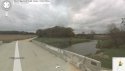
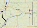
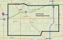
I will try and do a diagram to visually represent what we are looking for. We can go on Google Maps in the narrowed down location, and look for what they are describing here.

The Glass Marking Beads for Roads caught my attention. We don't know how long ago that was on the ashpalt road they are looking for, but, maybe we will get lucky, and it will show up on the Google Maps, which are often dated a few years ago.

That is a significant clue. Would LE be looking into which roads were resurfaced, painted, temporarily re-routed etc., in the last 10 years or so? Why would the road be formally surfaced in the glass beads?

Here is an image and some reference for the Glass Beads used in Highway Marking.

How in the heck did they figure out that the spot the vehicle backed down into was nearly treeless, but that there were birch and oak trees close by, but not directly over. WTH? GO LE!!!


150033829_Highway_safety_road_marking_glass_beads_with_EN1423_1424_standards_240.jpg

I can bring up that date on satellite history and see what I can find...
 
  • #482
Forgive me if it's been discussed, but, has the White Pines Forest Nature Preserve been discussed?

Not sure, still catching up to mark all searched areas. But this is all some great info to work with. Thank you, Wondergirl!

Off to start building overlays...
 
  • #483
Have they looked at Severson Dells Nature Preserve?
 
  • #484
  • #485
I started my walk-about last night, beginning just north of Dixon, IL along the river. Since LE has decided Timothy is most likely in Lee or Whiteside Counties, I am not going to go further north than Dixon for now. The map I posted upthread, clearly indicates that Dixon is the northernmost tip of Lee County. Am going to head south in Lee County now.

Here is 5587 West Edgewood Rd.. Picture here just to document.

I noticed that in this area, the roads seem very, very old, and possibly dirt?

The river is not very wide, and does not appear to be very deep either.

For anyone interested in doing the walk-about themselves, simply click on the Map Link below my picture, zoom out a bit, then go to the road you want to look at in streetview, drage the little orange man over to the road, and drop him on it. That will zoom you to streetlevel. Click on the arrows/circles to advance down the road, and use the arrows to look sideways, behind etc.

attachment.php


http://maps.google.ca/maps?q=sterli...oid=KkBrHeXac3j7moB60x7HPg&cbp=12,175.38,,0,0
 

Attachments

  • 5597_west_edgewood_rd_north_of_dixon_il.jpg
    5597_west_edgewood_rd_north_of_dixon_il.jpg
    97.2 KB · Views: 162
  • #486

Quoting myself here, but, making a correction.

This map that I posted yesterday, is incorrect. This is NOT Whiteside County. It is Carroll County. The link is incorrect, somehow.

I have almagamated all 6 counties, where LE has stated as above, that Timothy is probably located. I am not here to question what they have stated, I am going by what they have determined.

I made the following, amateur map. It indicates the 2 critical counties of Lee and Whiteside, along with the other 4. Next I will make a map showing the perimeters of these counties with cities, as best I can.

attachment.php
 

Attachments

  • county_maps_fry_pitzen_case.jpg
    county_maps_fry_pitzen_case.jpg
    51.9 KB · Views: 394
  • #487
  • #488
Whiteside County (from Mapquest, has a different look)

attachment.php


Lee County (physically located directly to the east/right of Whiteside County)

attachment.php
 

Attachments

  • whiteside_county_critical_search_area_1.jpg
    whiteside_county_critical_search_area_1.jpg
    90 KB · Views: 154
  • lee_county_critical_search_area.jpg
    lee_county_critical_search_area.jpg
    92.2 KB · Views: 152
  • #489
  • #490
  • #491
  • #492
If we go by what LE has stated:

-The land is NOT agricultural
-The land is NOT residential
-There is no corn growing nearby
-There is LIKELY a stream, river, creek or pond nearby
-Grassy meadow or treeless area
-Long grass, not cut
-ASHPHALT SECONDARY ROAD previously treated with glass marking beads
-WIDE gravel shoulder or turnaround

This does help narrow things down, really.

Whiteside and Lee Counties, probably not a main artery. Outside of the towns/cities, in all likelihood.

At least it's SOMETHING.

Where are you Timothy? :(
 
  • #493
I'm going to bypass looking at any locations along the main Rock River for now, with the assumption that she would not have put Timothy there, as he would have travelled. I am thinking more along the lines of something more remote, and perhaps still.
 
  • #494
I am not sure I understand the Jehovahs Witness connection?

No tangible connection other than I was looking in that area and came across Savanna, IL and saw a JV church there. It has been documented that they will try take children and convert them....not saying that's true or not, but that's why I included the excerpt.

I still believe she made arrangements and intended to give her son a better life in her perception....so just trying to think who could have been willing to take him and not return him.
 
  • #495
first thought upon reviewing the case, for some reason I am thinking Timothy is within 3-5 miles of the motel where the mother passed...I wonder how far she was emotionally able to drive/travel after presumedly 'losing' her son.

is there a name for the motel on 11th in Rockford? I must have missed that...
 
  • #496
If Amy made the trips in winter, to case for a spot to put Timothy (as opposed to meeting up with someone to arrange to take him), would the rivers have been frozen? Can any locals give us an idea of the wintertime around Sterling, Rock Falls and Dixon?

Toll Highway Map for Illinois, also shows counties:


http://www.illinoisvirtualtollway.com/


http://www.illinoistollway.com/pls/...L_MAPS_SYSTEM_MAP/ILTWYMAP_2011-SIDEA-WEB.PDF


Police also said that after accessing Fry-Pitzen's I-Pass account, they learned she made two trips to the area of Dixon, Rock Falls and Sterling in the winter that relatives cannot explain.

Fry-Pitzen traveled through the Orchard Road Toll Plaza in Aurora on Feb. 18 at 3:58 p.m., the DeKalb Toll Plaza at 4:21 p.m. and the Dixon Toll Plaza at 4:45 p.m. She then apparently returned the same day via Dixon at 8:58 p.m., DeKalb at 9:21 p.m. Orchard Road at 9:44 p.m. The second trip was on March 20 when her transponder passed through Orchard Road at 9:11 a.m., DeKalb at 9:34 a.m. and Dixon at 9:59 a.m. Her return trip on the same day showed her in Dixon at 3:42 p.m., DeKalb at 4:07 p.m., and Orchard Road at 4:30 p.m.

http://www.chicagotribune.com/news/...missing-aurora-boy-6-20110811,0,4021359.story
 

Attachments

  • #497
first thought upon reviewing the case, for some reason I am thinking Timothy is within 3-5 miles of the motel where the mother passed...I wonder how far she was emotionally able to drive/travel after presumedly 'losing' her son.

is there a name for the motel on 11th in Rockford? I must have missed that...

Reports list it as the Rockford Inn. http://chicago.cbslocal.com/2011/05/25/new-video-shows-missing-boy-at-resort/

The store she was seen at @8 pm was 10 miles from the motel. So she drove at least that far.
 
  • #498
Close to where she stopped in Winnebago would be Pecatonica Wetlands, or Seward Forest Preserve.

What about somewhere with caves and crevices? Mississippi Palisades is one, but is further afield.
 
  • #499
If Amy made the trips in winter, to case for a spot to put Timothy (as opposed to meeting up with someone to arrange to take him), would the rivers have been frozen? Can any locals give us an idea of the wintertime around Sterling, Rock Falls and Dixon?

I don't know if all of the rivers would have been completely frozen; some might not freeze completely depending on a lot of factors.

But I think it's doubtful that she made the Feb 18th trip to scope out a spot to 'put' Timmothy. Not only was it dark when she was out there on that trip, but there would have been snow on the ground. Not sure what the weather was for the March 20th trip, which was during the day.

I think it's interesting that both those trips were made on the 3rd weekend of the month (the February one on a Fri., the March one on a Sun.). Makes me wonder if she also went out there the 3rd weekend of January and/or April without using her iPass. Also makes me wonder whether she attended some sort of function or if she was just meeting someone and it's a coincidence that it was the same weekend both months.
 
  • #500
One last thought before I call it a night. She went to school at Iowa State. Could she have been headed to somewhere that was familiar to her? There was certainly time for her to go further afield.
 
Status
Not open for further replies.

Members online

Online statistics

Members online
112
Guests online
2,445
Total visitors
2,557

Forum statistics

Threads
633,040
Messages
18,635,452
Members
243,389
Latest member
Buffy_2009
Back
Top