- Joined
- May 24, 2012
- Messages
- 202
- Reaction score
- 663
From what I read, it had a drum-style brake in rear that enthusiasts remove. Darn, lost the link.
They are then left with only a front brake? What happens when they break suddenly?


From what I read, it had a drum-style brake in rear that enthusiasts remove. Darn, lost the link.
'HERE is a Google-Earth photo of the Whiskey Bay area, with the waterways labeled. Check the bend upstream. It looks subtle, but with a large mass of water, that bend has a bigger effect than you'd think.
Look at my possible DROP SITE and path for the bike.
The water looks low and calm yesterday morning before that storm front blew through:
29 Pictures of Whiskey Bay Exit from May 31st, 2012:
http://www.theadvertiser.com/articl...sey=tab|topnews|text|frontpage&nclick_check=1
What camp is up there? I can't read what you wrote in red.
Whiskey Bay Pilot Channel at I10 May 21, 2011 - YouTube
Does anyone know if this has been posted or discussed yet? Apparently this was recorded the Monday after the disappearance. I happened across it while researching the river and possible conditions. If the theory of dumping anything here by boat is correct, it's hard to imagine not having to run half the boat up on the bank to remain still long enough to dump the bike. If dumped upstream, what's the chances that the bike and the grips would all separately wash up in the same area?
edit: oops! ignore the part about the date...I'm off about a year..LOL
They are then left with only a front brake? What happens when they break suddenly?
The truck def has a distinguishing feature...a dark colored fuel door. Possibly Chrome. Is that an added dealer detail?
Here's another photo dated 5/27 from Daily Advertiser ... you can see the 'boat ramp' sign in the photo:

Here's another photo dated 5/27 from Daily Advertiser ... you can see the 'boat ramp' sign in the photo:
There is a white truck right there in the picture, is that a Z 71? And even if it's not, who uses those trucks around town, say that one with the ladder in the back end.
There is a white truck right there in the picture, is that a Z 71? And even if it's not, who uses those trucks around town, say that one with the ladder in the back end.
If she turned left onto Brashear and then headed toward St Mary on Cherry St That would have pit her near there and missed the cameras. There is a plave some locals eat on the street by that lot that serves some fresh local food she probably has gone to and may habe been aware of a way to cut to the bike bath or coliseum rd from there.However the quickest and fastest way would have been to stay on St Landry.
They are then left with only a front brake? What happens when they break suddenly?
I saw it, and thank you. I don't have the experience with that type of waterway and it's 'behavior', so to speak, to determine the efeects of the bend. The fact that the bike and the grips were found separately in the same area, had me assuming that the site was approached by land, rather than waterway; but, you could be spot on about everything collecting there in a bend. The police did state that there was other "trash" in the area.
Correct. I believe that to be a "-->" (right arrow, mostly obscured by the sign in the direct line-of-sight to the photographer who snapped the photo) beneath the text on the sign.
ETA: Confirmed via Google Maps Street View. Right-facing arrow.
Which aligns perfectly with the river being situated off-camera, to the left of that shot; and with that area being well in excess of 2500' from the water's edge at the boat ramp.
For orientation purpose, this shot appears to have been snapped a couple hundred feet to the south of I-10, facing in a generally northern direction.
Hypothetical Math here but...
The distance between the bank cam and the St. Landry cam is roughly 1850 feet. If it took Mickey about a minute between camera shots she was going roughly 21mph.
If the truck passed the St. Landry camera about 1 min after Mickey (assuming it travelled 35mph) it would have been about 939 feet behind her.
Doing the math and assuming Mickey likely varied speeds I calculated the amount of time it would have taken the truck to catch up to Mickey and assumed she continued down Landry at 18-21 mph average.
I've marked the area on the on the map in which the truck would have caught up to her on the bicycle assuming it travelled 35mph and no stops.
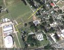
Does anyone know if the nursery/greenhouse at the corner of St. Landry and Colliseum is still actively used?
'HERE is a Google-Earth photo of the Whiskey Bay area, with the waterways labeled. Check the bend upstream. It looks subtle, but with a large mass of water, that bend has a bigger effect than you'd think.
Look at my possible DROP SITE and path for the bike.