GUILTY MI - Chelsea Bruck, 22, Frenchtown Twp, 26 Oct 2014 #3

Status
Not open for further replies.
  • #461
I don't think any articles were left intentionally at this newly discovered site, but rather by accident, or when in a rush to flee. I'm so interested in the roads, as I am thinking of someone impaired trying to navigate without detection....especially if they had human cargo onboard. It seems to me they would want to minimize the risk of detection by getting rid of the evidence as quickly as possible. At this point, they might be in a panic. This would either be a local, or someone who grew up locally who traveled back in (from college?) for this party. But most likely someone still right in the area.

I know several of you have mentioned there are bodies of water all over the place that seem like prime as a leave off spot. However, unless premeditated, that would require weights, rope, etc. So I am thinking more of a well, a cave....anything like that close by?
Alternatively, she could have been left anywhere out in the open, somewhere obscure of course.
 
  • #462
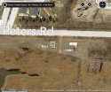
I found Bing Maps to provide more detail than Google Maps for this area;

North is to the right in this picture. View is looking east to west.

peters rd.JPG
 
  • #463
monster (not!), I agree that you were able to describe this area so well that I feel like I have seen it with my own eyes. Amazing job, and thank you.

Dumpsters in the area? Why did that slip my mind? If a body was dumped, it is long gone, unfortunately.

I am somewhat surprised that the area has been cleared already. It seems it would take days to go over every inch of it adequately. Also, it seems there would be signs indicating "Private Proertly" or "Do Not Enter ... contaminated area", etc. I wonder why it is not marked in such a way.

JMO
 
  • #464
What is Mayes Cave near Vreeland? When I googled caves near flat rock this came up, but is a housing development?
 
  • #465
I found Bing Maps to provide more detail than Google Maps for this area;

North is to the right in this picture. View is looking east to west.

View attachment 72706

Excellent map/pic! Thank you for this. I have been wondering about that body of water at the bottom left corner. How large, how deep, was it searched thoroughly?
 
  • #466
Monster12 (I'm sure you're not!), do you have knowledge about the proximity of Target Steel to the site where items possibly belonging to Chelsea were found? The company likely has several dumpsters on their property. Is it close enough and easily accessed that someone could walk or drive to that location to dispose of evidence?

Yes, Target Steel is located on the other side of the RR tracks where Peters and Vreeland Rd intersect. I was waiting in front of it the other day for the train to pass. It is located right across from the train yard. Unless you cut through the train tracks and yard and jumped the fence, you would have to follow the road down and around to get up to the abandoned buildings. 6.JPG

As I drove down Peters, there was a fence along the road before crossing into the train yard that was overgrown with trees and bushes.

There are a few other businesses by Target Steel. From the map, it says a vet is down Cahill Rd, welding place, and some other buildings/businesses that I never really pay attention to. I believe Target Steel is gated and fenced but not sure about the back end of it...at least the other day I noticed that an area where you would scan/check in to get through the gate but I could be wrong. It backs right up to the woods and seems pretty open....but probably not traveled through because there would be nowhere really for you to go. I wouldn't imagine this is a place that operates at night so it could be a place to dispose of items if you went around back or in/through the woods. The area is fairly dark at night from what I remembered. 7.JPG

I never seemed to notice Cahill Rd also runs north/south from Vreeland to Gibraltar, but it seems more residential and a less traveled road than Hall Rd is. Another possibility could be throwing evidence onto a train...now I know it may not be the most likely case and would hopefully have been discovered by someone, but you never know. Or it was carried up there on a train and blew off into the field? Silly to think but just what is coming to mind.

I agree with the post about dumping in water and not being prepared for that...didn't think of all that would be involved in that. To the west in another part of Flat Rock, is the Huron River and the dam at a park.

I thought it was weird that nothing was roped or flagged also. Maybe for some reason they couldn't or didn't want to draw attention to it by kids nearby that would want to go check it out themselves? I'm just rambling what comes to mind. I don't recall seeing 'keep out' signs but I may have just not noticed them. It led me to believe that maybe what they found wasn't as related to her as they believed because wouldn't it become part of a crime scene investigation then? I don't really know how that works but if it comes back and does show DNA belonging to her, you would think they would want to use that area to find more clues, which I don't believe they were able to look over the whole area in 2 days. It has been raining here for the past two days so that area is definitely full of water and mud.
 
  • #467
Monster12 (I'm sure you're not!), do you have knowledge about the proximity of Target Steel to the site where items possibly belonging to Chelsea were found? The company likely has several dumpsters on their property. Is it close enough and easily accessed that someone could walk or drive to that location to dispose of evidence?

Driving would be easy, but walking looks difficult. I believe Target Steel is the blue #1 on this map. From that Peters rd. site, one would have to cross the field, and several tracks, and Vreeland Rd. to get there.
 

Attachments

  • image.jpg
    image.jpg
    281.8 KB · Views: 226
  • #468
That is a good view of the buildings. I don't think I noticed that third one in there before. When I looked at it from above, it showed a trail going to that third building and then continuing back into the woods. I would assume this was for transporting whatever it is they used to do at this site. I wonder if people still drive back there or if it is watched over as private property.

When driving down Peters Road, the buildings seemed closer to the road then some of the maps are showing. The trees are pretty bare right now so although it looks like the trailer park is blocked from seeing the buildings, I think they can see more now that the trees aren't full of leaves as much. That bing map shows the ground pretty cleared (birds eye view I think?) and I don't recall that from my viewing of it. It seemed like more dirt piles/hills were built up, almost to shield or start to block the building. I didn't look into the dates on the google map vs. bing but it is interesting how different it can look with a different view and time of the year. When I just checked bing (aerial), it showed the land full of green trees and almost a complete blocking of view from the trailer park to the buildings. Either way...it would be interesting to hear about how this land is actually used and who goes there....8.JPG

In regards to the Mayes Cave, I have never heard of that. I would guess it is just what someone calls their home because when I googled it, a link for 4square came up. Sometimes people/kids will name their "house" and their friends will "check in" to their house on facebook, 4square, etc.

I know from living in this area, several homes have storm drains that go into our ditches and streams. Not all of the areas have actual piping to carry the water to where it needs to go. Some homes still have ditches in front of their houses. I know of an area where the homeowners had a ditch in the front and back of their lots and a huge storm drain that ran along side their house under the driveway. Unfortunately, kids used to play in them. That's about all of the "cave" type things I know about in this area.
 
  • #469
It might be that they are waiting to find out from the lab if the costume even belongs to Chelsea before they do any more searching. They probably spent a lot of money on the other search so their holding back.

Maybe did a quick air sweep and probably didn't see anything.
 
  • #470
monster (not!), I agree that you were able to describe this area so well that I feel like I have seen it with my own eyes. Amazing job, and thank you.

Dumpsters in the area? Why did that slip my mind? If a body was dumped, it is long gone, unfortunately.

I am somewhat surprised that the area has been cleared already. It seems it would take days to go over every inch of it adequately. Also, it seems there would be signs indicating "Private Proertly" or "Do Not Enter ... contaminated area", etc. I wonder why it is not marked in such a way.

JMO

Dumpsters = landfills. Too sad to think about in this case :(
 
  • #471
Dumpsters = landfills. Too sad to think about in this case :(
BDE...Sadly, my gut tells me they REALLY need to follow up on where those dumpsters go.

Leveraging what was stated up thread, the perp likely did not have anything to weigh a body down for water, tools to bury, and I'm thinking the next option large enough to conceal a body is a dumpster.

Google maps landfills near Flat Rock returns several in the area. [emoji20]
 
  • #472
BDE...Sadly, my gut tells me they REALLY need to follow up on where those dumpsters go.

Leveraging what was stated up thread, the perp likely did not have anything to weigh a body down for water, tools to bury, and I'm thinking the next option large enough to conceal a body is a dumpster.

Google maps landfills near Flat Rock returns several in the area. [emoji20]

I'm wondering.... if her abduction was something planned, then the perp/🤬🤬🤬🤬 might have had tools and a place all figured in advance, etc....
the piece of her costume that was found may just be a ruse to throw LE off ....
Am I sure of this, no.... but if nothing more is found in the area, then perhaps...
 
  • #473
I wonder if someone in the area with a GPS gets bored, if they might want to set it to the setting for avoiding highways or whatever sometime, and see if they get routed down this road for any reason from anywhere nearby, depending on where the endpoint might be. If that makes any grammatical sense. I'm so deeply pondering I may not be grammaring.
 
  • #474
I found Bing Maps to provide more detail than Google Maps for this area;

North is to the right in this picture. View is looking east to west.

View attachment 72706

I wonder if that brown roofed building has been searched..? Would they have had a search warrant for all 60 acres or just for that one building, anyone know?
 
  • #475
I drove past the buildings again today a bit ago and here are some thoughts:

1. Coming from Van Horn to the north and turning onto Peters I did notice fencing up with fading signs. It looked like they said something about no trespassing, dangerous materials/chemicals in area, since it was an industrial area. I couldn't read it but the signs were posted on some of the fencing, which I noticed much more of it today then the other day.

2. It seemed that today more areas were blocked off to restrict access into the buildings and that trail we spotted. That is probably why I never saw it the other day. I didn't slow down or stop today partly because I don't want to and there was some sort of city truck parked where the road turns. I'm not sure what for or why and when I drove by they were just sitting in the truck. But the area in front of the buildings didn't seem as open today. I noticed more fencing (which I know didn't just suddenly appear) and more dirt piles/hills (which could have been built up more).

3. There was another area a little past the building that was opened with no wire fencing and had a gate that looks like it once opened up, which may have been leading to the road/trail. I think it was a pic they showed on the news. It had a ton of dirt/mud piled under it and what looked like a giant tree stump in front of it. Someone is obviously trying to keep people out of this area because it seemed an opening that was there, was blocked or looked like they were trying to close up any way someone could walk in. I wish I could remember if I saw all of this on Tuesday because I didn't remember it looking so blocked off the other day.

4. Something about how all of this came to be just isn't making sense to me. I know a lot of people know about her story but unfortunately I feel in this area that it is not as known as it would be down in Monroe. I know several people around here that don't know what I'm talking about when I mention it and you don't see the flyers as much. Even if they saw the flyers, I would have to guess most younger people won't stop to read them or look to see what it was about.

So my point being, if someone did stumble upon something, whether it was just the leaf in the ditch or the clothes in the field, it seems a bit out of the ordinary that they would immediately think of her unless by chance, they did know alot about her story...which is great and they reported it. With as much wooded area and trees in that section of land, I just keep asking myself what would make someone stop to pick up THAT leaf when there are tons of leaves/grass/etc around because they realized it was a fabric leaf. Unless you were specifically out looking for items like that, there is so much garbage and junk on the side of this road that it just seems a bit odd to me that a green leaf, that would be blending in with grass, mud, dirt, garbage, would jump out at someone. But maybe they just happened to bend over at that spot or somehow it did catch their eye. Maybe they are just more observant than I would be but something about how all of this played out just isn't making sense with me the more I look at the area and think about what they are telling us happened.

There is a waste management landfill close by off sibley road over 75 I do believe...which is just a bit north.
 
  • #476
Also, a Flat Rock woman went missing in early October, but I cannot find anything on the story. I believe she was found but when I search her name, NOTHING comes up...which is weird. She was missing around October 9 and one article I read had her flyer with Chelsea's and the Kalkaska woman. Not saying there is a connection but just remembered the city connection...

http://www.nbc24.com/news/story.aspx?id=1116321
 
  • #477
View attachment 72697View attachment 72698View attachment 72699View attachment 72700From my experiences driving in that area and also looking at an aerial map, the field extends north quite a bit but backs up to several buildings that are on Van Horn. It runs into the train yard to the east, trailer park to the south, and north/northwest to Van Horn Rd. I believe there are office buildings and a UAW type building that it would eventually back up to if you were to be walking through it. I am not sure if it is all fenced off or how easy it is to be walking through there. From the aerial view, it looks swampy and open. I do not know much about that specific area since I didn't even know those buildings were there, but I do know the train yard is active, especially since I was caught by a train for about 20 minutes on my way there. Further down Vreeland Rd to the east is the Ford plant and a 75 overpass. Whenever I pass through the surrounding areas (not the field itself), it seems like a pretty active area with a lot of traffic, walkers, bikers, etc.

I also wanted to add that the trailer park has a pretty clear view of building/field. If a car was out there in the middle of the night/causing noise, you would think someone might hear or notice. But then again, if no windows were open and it was really late/early, maybe they went unnoticed. I don't really know of any areas nearby that stick out. Besides the train yard, there are houses, a high school, subdivisions, church, and Telegraph is a very busy main road nearby. Peters only connects to Van Horn and Vreeland Rd, which are both "main roads" so to speak. One could also easily turn into the trailer Park, Deerfield Estates, but it opens back up to Peters Rd and the main entrance is on Telegraph. Both Vreeland and Van Horn run east and west, with Telegraph to the west and Allen Rd, being the next main road so to speak, to the east. Neither roads connect directly to I-75 and you would have to take either Gibraltar Rd or West Rd to get to an entrance or exit ramp for the freeway. 275 is to the west of this spot, but again, no quick escapes. That is why this location is boggling my mind because it is not a direct route from anywhere in any direction. If you were coming from the party to the south/southeast, you would need to do a lot of navigating down side roads to get to this spot. There is a small side road, Hall Rd, that connects Gibraltar Rd to Van Horn. It has the train yard on the east side and a field to the west, with I think 2-3 small businesses. It is a straight road and always reminds me of an airport runway. You could also take back roads through Rockwood to get to 75 or Fort St down to Monroe.

I guess speculating the route took does not do us any good. It could also be that the perp had her belongings in his possession, but not her. They saw this as a place to dispose of them as being vacant and not traveled by people, legally at least, like a park or near the lakes. I really hope one day she can sit and tell us all what happened and all is well.

Pic 1: Shows overall area
Pic 2: Location in reference to 75 and main roads to travel
Pic 3: Open area across from building that I never noticed while driving
Pic 4: Overall field view showing wet areas/open field/trees
I have lived in this area all my life. I am about 2 miles from the building and have family in Newport/Monroe on Lake Erie. The areas are both, in my opinion, pretty remote and you wouldn't just stumble upon them. The other day I drove down Peters Rd to see for myself the area (Nobody was there searching nor was I in the way of any investigations). I turned down Peters from Vreeland Rd and it is a "dirt" road but was pretty compacted and it was smooth, so it almost felt paved. I live on a dirt road so I know that sometimes it can feel paved but it really is not. I say this because I think someone mentioned above they believed the road was paved. There were a lot of potholes and garbage every where on the side of the road, including mattresses, clothing, food wrappers, plastic buckets, etc. It was a very odd assortment of things that caught my eye. The trailer park is on the left side as I traveled north/northeast on Peters almost the whole way. I felt like the road never ended and finally it curved to the left and straight ahead I could see where it turned to pavement and Van Horn Rd. I was confused as to where this building was and then suddenly the trees cleared a bit and the buildings appeared. I did not see an actual road that led to them, but it could have been before I saw the buildings so I didn't notice it. Right beyond the edge of the road was a mound of dirt/brush that one would have to walk up and over to get to the building. I definitely got the chills and the only thing I kept thinking was how creepy and weird it felt. It felt like it suddenly got very quite and still and all I could hear was animals and birds. It felt so out of place to see a building like this. There was graffiti all over it and it seemed like the area surrounding it was full of grass, brush, garbage, broken fence and dirt. It didn't seem like a very clear area to navigate around.

Someone also mentioned a trail/road to drive on and I did not see that. However, there was a car in front of me checking it out also and one behind me, so I didn't want to slow down/stop. Being from the area and I have never found a reason to travel down this road before. I even had family that lived in the trailer park a long time ago and we never took this route or even knew where this road led too. I believe that anyone who would come down to this/head to this field definitely knew the area and where they were going. Like I said before, to head from Newport/Monroe and end up here does not happen accidentally. There isn't a major road that would lead you right to here.

One could take Telegraph Rd north from Monroe but then would have to know to turn down Vreeland or Van Horn to reach this area. You could also take 75 N or Old Fort Rd north (this is the route we take from visiting our family that lives near the party site), but then again, you would have to head west for a few miles to get near Peters Rd.

The last thing that caught my eye was after passing the buildings, the trees filled back in and then they were gone and it opened up to a small pond and field. I think it would be some sort of drainage or retention pond and I believe it was fenced in. I could see the whole thing so it wasn't that large but it was maybe around the size of half a football field? Unfortunately, the thought immediately came into my mind that if those items really did belong to Chelsea, the pond could be an area of interest...I would hope that was part of their search the other day but I am not sure. The rest of the side of the road was opened up to field, utility poles, and then Van Horn road.

Leads me to believe that there is an awfully odd connection between the man with the false reports from Flat Rock and then discovering this site. Did he maybe know someone else that was involved? Was he trying to make a report to cover up for a friend? Did someone plant this stuff here just to move the search focus to a different area? I guess since we don't really know what else was found it is hard to say. So many unknowns..

I cannot thank you enough for this, your erudition and eye. This is so close to you and you've been so kind and brave in going through the trouble, looking and taking the time to share it here, on WS. LE's investigation and forensics will give more answers, it seems to me. Very much appreciated it. My heart was racing as I read it. Thanks.
 
  • #478
Also, a Flat Rock woman went missing in early October, but I cannot find anything on the story. I believe she was found but when I search her name, NOTHING comes up...which is weird. She was missing around October 9 and one article I read had her flyer with Chelsea's and the Kalkaska woman. Not saying there is a connection but just remembered the city connection...

http://www.nbc24.com/news/story.aspx?id=1116321
I am pretty sure that Connie from Kalkaska was found deceased. The other missing girl DCG I recall something not quite "right" with that one. I cannot remember details but I think she might have had some sort of "issues".
 
  • #479
Yes, I do recall hearing that Connie was found in the woods in water or something like that. Just odd I couldn't find any info on the other girl. I would be willing to take pictures of the location if anyone would be interested/if that's allowed on here. If not, I could always message them. I will not be getting out of my car, but next time I'm in the area I could take some of the road and what it is like in real time.
 
  • #480
I drove past the buildings again today a bit ago and here are some thoughts:

1. Coming from Van Horn to the north and turning onto Peters I did notice fencing up with fading signs. It looked like they said something about no trespassing, dangerous materials/chemicals in area, since it was an industrial area. I couldn't read it but the signs were posted on some of the fencing, which I noticed much more of it today then the other day.

2. It seemed that today more areas were blocked off to restrict access into the buildings and that trail we spotted. That is probably why I never saw it the other day. I didn't slow down or stop today partly because I don't want to and there was some sort of city truck parked where the road turns. I'm not sure what for or why and when I drove by they were just sitting in the truck. But the area in front of the buildings didn't seem as open today. I noticed more fencing (which I know didn't just suddenly appear) and more dirt piles/hills (which could have been built up more).

3. There was another area a little past the building that was opened with no wire fencing and had a gate that looks like it once opened up, which may have been leading to the road/trail. I think it was a pic they showed on the news. It had a ton of dirt/mud piled under it and what looked like a giant tree stump in front of it. Someone is obviously trying to keep people out of this area because it seemed an opening that was there, was blocked or looked like they were trying to close up any way someone could walk in. I wish I could remember if I saw all of this on Tuesday because I didn't remember it looking so blocked off the other day.

4. Something about how all of this came to be just isn't making sense to me. I know a lot of people know about her story but unfortunately I feel in this area that it is not as known as it would be down in Monroe. I know several people around here that don't know what I'm talking about when I mention it and you don't see the flyers as much. Even if they saw the flyers, I would have to guess most younger people won't stop to read them or look to see what it was about.

So my point being, if someone did stumble upon something, whether it was just the leaf in the ditch or the clothes in the field, it seems a bit out of the ordinary that they would immediately think of her unless by chance, they did know alot about her story...which is great and they reported it. With as much wooded area and trees in that section of land, I just keep asking myself what would make someone stop to pick up THAT leaf when there are tons of leaves/grass/etc around because they realized it was a fabric leaf. Unless you were specifically out looking for items like that, there is so much garbage and junk on the side of this road that it just seems a bit odd to me that a green leaf, that would be blending in with grass, mud, dirt, garbage, would jump out at someone. But maybe they just happened to bend over at that spot or somehow it did catch their eye. Maybe they are just more observant than I would be but something about how all of this played out just isn't making sense with me the more I look at the area and think about what they are telling us happened.

There is a waste management landfill close by off sibley road over 75 I do believe...which is just a bit north.

Thank you thank you thank you....

Does anyone remember in the early reports who she said she was going to the party with? I read somewhere that someone said she was going with her friends from Flat Rock? I thought I heard she was going with people from work? I assumed that someone just wanted to throw in the Flat Rock reference to tie back to this but I wasn't sure what the actual "report" was back in October.

Mrs. Bruck mentioned in yesterdays PC covered by numerous MSM that Chelsea's earlier ride to the BM's bash didn't work out, and she then waited until late, to go with friends, so getting a ride may have been a chore for her that night. The friends who were with her and friends who looked for her at the end of the party were the ones who alerted the family that she went missing, and continue to look for her, if I'm seeing things correctly.

If somebody was laying in wait for Chelsea at that bash, I imagine they were getting antsy as she was so late. If this is possible, it could mean something, be someway to track those antsy people waiting for Chelsea?
 
Status
Not open for further replies.

Members online

Online statistics

Members online
144
Guests online
5,108
Total visitors
5,252

Forum statistics

Threads
633,266
Messages
18,638,788
Members
243,460
Latest member
joanjettofarc
Back
Top