

You are using an out of date browser. It may not display this or other websites correctly.
You should upgrade or use an alternative browser.
You should upgrade or use an alternative browser.
Northwest States - AK, OR, WA, ID, MT, WY - Weather Discussion
- Thread starter CarmelEyesD
- Start date
- Joined
- Jun 9, 2016
- Messages
- 42,098
- Reaction score
- 214,516
Geologists say recent earthquakes not tied to Yellowstone Caldera
The Yellowstone Caldera quietly settled across its 1,500 square miles on Tuesday evening, uninterrupted by Yellowstone National Park visitors or the magnitude 6.5 earthquake near Challis, Idaho, that shook Boise residents to the southwest. Two weeks earlier, the Salt Lake City suburb of Magna, Utah, rattled with a magnitude 5.7 tremor that could be felt by southwest Wyoming residents.
Those two quakes, separated by 339 miles, are in relatively close proximity to the caldera, intimidatingly known to some as the Yellowstone Supervolcano. According to scientists who have spent their careers studying the area, those two recent noteworthy shakes were unrelated and have caused no threat to the Yellowstone Caldera.
“The Magna earthquakes in Utah were perhaps on the Wasatch Fault Line and perhaps near there and they are unrelated to what may happen in Yellowstone,” Mark Milligan, geologist at the Utah Geographical Survey, said. “There’s no relation there.”
The Wasatch Fault, running on the west side of the Wasatch Mountains, extends 240 miles from central Utah into southern Idaho. While geologists like Milligan have identified several active points stretching into Idaho, Tuesday evening’s activity outside Boise was not caused by movement on the Wasatch Fault nor from underlying activity at Yellowstone. If Yellowstone is impacted at all by these recent tremors, geologists are eager to watch for it in altered scheduling in geyser eruptions. After all, the 1983 magnitude 6.9 Idaho earthquake that sent aftershocks and triggered micro-earthquakes throughout Yellowstone disrupted the park’s most famous geyser.
Read more: Geologists say recent earthquakes not tied to Yellowstone Caldera
- Joined
- Jun 9, 2016
- Messages
- 42,098
- Reaction score
- 214,516
Rep. Dorothy Moon's cabin damaged by Idaho earthquake
[...]
Dorothy Moon represents District 8-B in the Idaho Legislature. That's Lemhi, Custer, Boise, Gem and Valley counties.
She was doing business in southern Idaho on Tuesday went the quake struck.
But she actually owns a cabin just east of Stanley, which is about 25 miles from the earthquake's epicenter.
[...]
So far she hasn't heard much about structural damage but there has been a lot of reports about glasses falling off shelves and clocks not working, as well as some foundational cracks.
The earthquake left a huge crack through her garage and even lifted up some of the concrete at her cabin.
Moon recommends everyone assess the damage around their homes now and not wait until later.
"There could be some damage to your underlying structures that you're not aware of yet," Moon said. "Over an 18-hour period there was two feet of snow dumped in the higher elevations near Stanley, so any building there could have potential damage."
Lots of pictures from earthquake at link: Rep. Dorothy Moon's cabin damaged by Idaho earthquake
[...]
Dorothy Moon represents District 8-B in the Idaho Legislature. That's Lemhi, Custer, Boise, Gem and Valley counties.
She was doing business in southern Idaho on Tuesday went the quake struck.
But she actually owns a cabin just east of Stanley, which is about 25 miles from the earthquake's epicenter.
[...]
So far she hasn't heard much about structural damage but there has been a lot of reports about glasses falling off shelves and clocks not working, as well as some foundational cracks.
The earthquake left a huge crack through her garage and even lifted up some of the concrete at her cabin.
Moon recommends everyone assess the damage around their homes now and not wait until later.
"There could be some damage to your underlying structures that you're not aware of yet," Moon said. "Over an 18-hour period there was two feet of snow dumped in the higher elevations near Stanley, so any building there could have potential damage."
Lots of pictures from earthquake at link: Rep. Dorothy Moon's cabin damaged by Idaho earthquake
- Joined
- Jun 9, 2016
- Messages
- 42,098
- Reaction score
- 214,516
Many Idahoans were already feeling a bit shaken by the events of March. And that was before the earthquake.
A magnitude 6.5 earthquake struck in the Challis National Forest around 5:52 p.m. Tuesday, centered near Shake Creek — no, really — just northwest of Stanley and 72 miles northeast of Boise, followed by smaller aftershocks.
People reported feeling the quake as far away as Moscow, Spokane, Montana and Nevada. No loss of life and minimal damage has been reported thus far.
"Perceived shaking for the quake was very strong," the U.S. Geological Survey reported. "The event was widely felt, with close to 16,000 'Did You Feel It?' reports thus far submitted, but likely to have low impact."
Even though it did little damage, Tuesday's quake was the strongest reported in Idaho since the October 1983 Borah Peak earthquake, a magnitude 6.9 quake that killed two people in Challis and resulted in over $12 million in damage in the Challis and Mackay areas.
Read more: Despite little damage, Tuesday's quake strongest since 1983
- Joined
- Jun 9, 2016
- Messages
- 42,098
- Reaction score
- 214,516
ITD reports bridges appear undamaged by earthquake, rockfall continues on some roadways from aftershocks; urges caution

Several mountain highways saw rockfall on the roadway following the quake. That includes Idaho Highway 75 (ID-75) near Stanley, ID-21 north and south of Lowman, ID-55 between Horseshoe Bend and Cascade, and ID-52 east of Emmett. Maintenance crews were immediately deployed to clear these hazards from the roadway and ensure the road was safe for travel.
Aftershocks continue to rock the region, causing additional rockfall. Crews are patrolling these high-risk areas to actively clean rocks from the highway. ITD urges the traveling public to use caution when driving in these areas.
[...]
IDAHO HIGHWAY 21 CLOSED BETWEEN LOWMAN AND STANLEY
A storm system dumped 27” of snow in the Canyon Creek section of Idaho Highway 21, from Grandjean to Banner Summit. This increased the risk of avalanches and ITD closed the highway at 2:00 p.m. Tuesday, several hours before the earthquake.
[...]
At this time, the number and extent of landslides on this section are unknown. There is no timeframe when crews can re-enter the Canyon and begin clearing the road. Additional repairs to the roadway may be required as well. The Department is advising it may be many days before this section of ID-21 re-opens. Idaho Highway 75 and U.S. 93 remain open to access Stanley.
ITD reports bridges appear undamaged by earthquake, rockfall continues on some roadways from aftershocks; urges caution
- Joined
- Jun 9, 2016
- Messages
- 42,098
- Reaction score
- 214,516
- Joined
- Jun 9, 2016
- Messages
- 42,098
- Reaction score
- 214,516
Central Idaho quakes likely stemmed from undocumented fault

According to the Associated Press, the U.S. Geological Survey had recorded 47 aftershocks, with one measuring magnitude 4.6, by mid-morning on Wednesday.
People may feel aftershocks for the next couple of weeks, but the USGS predicts the odds of an aftershock above magnitude 6.5 occurring during the next week is less than 1 percent, and the odds of an aftershock reaching at least magnitude 5 are about 20 percent.
"The reason for large aftershocks, sometimes when one fault moves it stresses another part of the fault and there's another earthquake," said Glenn Thackray, an Idaho State University geosciences professor.
Thackray said Boise State University seismologists were at the scene Wednesday seeking to record the aftershocks to better document the faults in the area.
"That will allow the fault to be mapped in the subsurface," Thackray said. "The aftershocks will tell us a lot about the fault itself."
Thackray said the major active fault in the vicinity extends along the front of the Sawtooth Range near Stanley, sloping underneath the valley and Red Fish Lake.
Thackray said the earthquakes don't appear to have originated from that large fault, which he's personally studied. Rather, they seem to have been caused by a strike-slip fault, where one block slides horizontally past an adjacent block. He said the fault was likely previously undocumented, or the earthquakes may have stemmed from some older faults in the area that have only been suspected to still be active.
"This is the sort of stuff that gets people excited about science and geology," Thackray said. "It's like bread and butter to us."
Thackray said there's no geological connection linking the recent earthquakes to a magnitude 5.9 earthquake that caused damage in Salt Lake City about two weeks earlier. Thackray described the occurrence of the two strong earthquakes in the same region within less than a month, on separate faults, as "a very strong coincidence but only a coincidence."
Central Idaho quakes likely stemmed from undocumented fault
- Joined
- Jun 9, 2016
- Messages
- 42,098
- Reaction score
- 214,516
- Joined
- Jun 9, 2016
- Messages
- 42,098
- Reaction score
- 214,516
- Joined
- Sep 1, 2015
- Messages
- 2,617
- Reaction score
- 19,475
Thank you.
And thanks to Gardener1850 for posting all the articles and information.
There has really not been any significant damage in populated areas. I believe a cross on a church in Boise was damaged.
I did confirm with a friend in my area that it did indeed hail where we live during the earthquake!
Today it was as if nothing happened. It was sunny although chilly and I took a nice walk in my neighborhood. I think the Covid19 issues have really overshadowed everything else.
Around 7 this evening, it began to snow and blow very hard..for about 5 minutes! Not really unusual in the spring for southwest Idaho. But it just underscores the strangeness this spring...a pandemic, an earthquake, snow on the first day of April.
It was a very strange and odd experience, since we are not used to feeling earthquakes here. Apparently we have a lot they are just too small to feel.
@ReadySet , glad you are OK!
Hatfield
Well-Known Member
- Joined
- May 3, 2012
- Messages
- 17,014
- Reaction score
- 157,643
I'm here in the Boise Valley. This is the first earthquake I've felt since the Borah Peak quake in 1983.
I was in the living room, and felt/heard the heavy furniture in the dining room shake behind me. The dishes rattled in the hutch. I thought my husband was stomping around there and was startled when I saw him in the kitchen. When I stood up the shaking continued and I was confused, had there been an explosion, was it thunder? At the same time it started to hail. It had been rainy and overcast all day.
My husband confirmed it was an earthquake. As we stood in the doorway between the kitchen and dining room, we could see and feel the walls move. I was shocked how long it lasted. I couldn't believe we'd had an earthquake.
There was nothing on the news at first which made things further confusing. Finally the news picked it up and we started hearing from friends and family. My friends who live south of Missoula also felt it, but not to the extent we did.
There have been aftershocks but we haven't felt them. The epicenter was about 80 miles from Boise.
WOW. A 6.5 is pretty large of a quake. Glad you are ok and hope all others are ok from it.
Ive felt small ones from oil rig fracking but never felt one above about a 3.5 which was bad enough for me. What I remember the most was the loud sound was just like rolling thunder to me. I had first thought the rumbling thunder noise was a storm coming in but when I started to feel the ground shake I knew the sound must have been due to the small earthquake we experienced.
Im not sure if all earthquakes have thunderous sounds like the one I experienced.
- Joined
- Jun 7, 2016
- Messages
- 3,115
- Reaction score
- 49,752
I am searching for a link now. This news is just breaking.
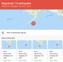
7.4 earthquake strikes off the coast of Alaska. There is a tsunami warning for the south Alaska and the Alaskan Peninsula, from Kennedy Entrance to Unimak Pass.
In the time it has taken me to post this, it has been upgraded to a 7.8.
U.S. Tsunami Warning Centers
Aleutian earthquake triggers tsunami warning for Sand Point, Cold Bay and Kodiak - Alaska Public Media
Current Warnings - International Tsunami Information Center
National Data Buoy Center
Last edited:
- Joined
- Jun 7, 2016
- Messages
- 3,115
- Reaction score
- 49,752
Earthquake in Alaska: Tsunami warning after enormous 7.8m tremor strikes off coast | Daily Mail Online
Earthquake off Alaska triggers tsuani warning and evacuations
there appears to have been a 5.2 aftershock. (will post links soon).
no threat to california, oregon, or washington state per USGS twitter.
Earthquake off Alaska triggers tsuani warning and evacuations
there appears to have been a 5.2 aftershock. (will post links soon).
no threat to california, oregon, or washington state per USGS twitter.
Last edited:
OMG! That's huge!I am searching for a link now. This news is just breaking.
7.4 earthquake strikes off the coast of Alaska. There is a tsunami warning for the south Alaska and the Alaskan Peninsula, from Kennedy Entrance to Unimak Pass.
In the time it has taken me to post this, it has been upgraded to a 7.8.
U.S. Tsunami Warning Centers
Aleutian earthquake triggers tsunami warning for Sand Point, Cold Bay and Kodiak - Alaska Public Media
Current Warnings - International Tsunami Information Center
National Data Buoy Center
Any deaths?
- Joined
- Jun 7, 2016
- Messages
- 3,115
- Reaction score
- 49,752
OMG! That's huge!
Any deaths?
Not so far. News just broke about an hour ago, so I am just refreshing on twitter. (that appears to be the best way to get breaking news right now, search "Alaska earthquake" and then "latest." Not too many reports of people feeling the quake, so I don't know what that means.
2020 is a mess.
- Joined
- Jun 7, 2016
- Messages
- 3,115
- Reaction score
- 49,752
This is a screenshot from USGS. it appears there have been 5 EQ's on July 22, 2020. (there is one ss missing bc when i upload the file, it adds some weird photo and i cannot tell what that is, nor can i delete it. weird.) The missing ss lists an M6.1, 498 km from Unalaska.
Attachments
That EQ was huge!This is a screenshot from USGS. it appears there have been 5 EQ's on July 22, 2020. (there is one ss missing bc when i upload the file, it adds some weird photo and i cannot tell what that is, nor can i delete it. weird.) The missing ss lists an M6.1, 498 km from Unalaska.
Do you know if it was a populated area?
- Joined
- Jun 7, 2016
- Messages
- 3,115
- Reaction score
- 49,752
- Joined
- Jun 7, 2016
- Messages
- 3,115
- Reaction score
- 49,752
That EQ was huge!
Do you know if it was a populated area?
i don't know. if you go on youtube and search for agenda free tv, he is following all the breaking news about the eq live. it's very informative. (can't post the link here.). stay safe!
Guardians Monthly Goal

Goal Reached! We hit our target of 75 new Guardians!
New stretch goal: 100!
Our goal for the month is 75 new Guardians members to sign up. Have you been thinking about becoming a member?
Click here to find out how!
Online statistics
- Members online
- 130
- Guests online
- 1,382
- Total visitors
- 1,512
Totals may include hidden visitors.
Forum statistics
Community Rules
-
Be CivilTreat all members with respect. No personal attacks, harassment, or inflammatory language.
-
Victim FriendlyAlways show respect for victims and their families. No victim blaming or insensitive speculation.
-
Fact-based SourcingProvide credible sources for claims. Distinguish between verified facts and personal theories.
-
Social Media UseDo not post direct links to personal social media profiles of private individuals.
-
Copyright and PaywallsDo not copy full articles. Summarize and link to the original source instead.
-
Privacy and Personal InformationDo not post personal information such as addresses, phone numbers, or workplaces.
-
Registered Sex-OffendersDo not name or speculate about RSOs unless officially named in connection to a case.
-
Stay On TopicKeep discussions relevant to the case or topic at hand. Avoid off-topic tangents.
-
Accounts, Moderation, and DisputesOne account per person. Contact moderators privately for disputes or concerns.
-
Solicitation and FundraisingNo solicitation, fundraising, or promotion of personal ventures without approval.