Found Deceased OR - Karissa Alyn Fretwell, 25, William "Billy" Fretwell, Toddler, Salem, 13 May 2019 *ARREST*

Status
Not open for further replies.
  • #1,001
The bodies were found on Weyerhauser property. Can someone with a computer (not a microscopic cell phone screen) determine if Turner Creek gate was locked during May? I know they sometimes issue gate keys to permit holders. I'm just curious if the area was gated at the time.


I know of no way of knowing if the gate was locked based on maps or satellyte photos. My understanding from my sons who work in the logging industry is that the gates are locked at night. This is particularly true during fire season. However; the gates block vehicles that need roads but can be circumvented on an ATV.

In perusing the maps I see that MW could have rode from his home, up Phillips road, crossed a neighbor's property to reach the power line trail, then used a combination of gravel roads and trails to get to Mt Richmond road. Just South of the intersection with Gerrish Valley road and Ford road with Mt Richmond is a Weherhayser property with trails that can also be accessed from Turner Creek road.

Does anyone know exactly where the bodies were found?
Could you drop a pin on Googlemaps?
 
Last edited:
  • #1,002
I know of no way of knowing if the gate was locked based on maps or satellyte photos. My understanding from my sons who work in the logging industry is that the gates are locked at night. This is particularly true during fire season. However; the gates block vehicles that need roads but can be circumvented on an ATV.

In perusing the maps I see that MW could have rode from his home, up Phillips road, crossed a neighbor's property to reach the power line trail, then used a combination of gravel roads and trails to get to Mt Richmond road. Just South of the intersection with Gerrish Valley road and Ford road with Mt Richmond is a Weherhayser property with trails that can also be accessed from Turner Creek road.

Does anyone know exactly where the bodies were found?
Could you drop a pin on Googlemaps?

Info on gate...

Permit FAQs :: Weyerhaeuser

No specific location was give but I remember a general "about a mile and a half up a spur road". Though I can't find that quote in press releases now.
 
  • #1,003
  • #1,004
Wednesday, July 10th:
*Hearing-Initial Appearance (@ 1:10pm PT) - OR – Karissa Alyn Fretwell (25) & William “Billy” Alan Fretwell II (3) (last seen May 13, 2019, reported missing May 17, 2019, Salem; found June 15, 2019 approx. 10 miles west from Yamhill on Weyerhauser property off Turner Creek Rd. LE believe they were dead on May 16, 2019) – *Michael John Wolfe (52) “father of Billy” – sought for questioning since 5/23/19, arrested (5/23/19), charged (5/28/19), indicted (6/6/19) & arraigned (6/21/19) with 2 counts of aggravated murder, 1 count of aggravated murder constituting domestic violence, & 2 counts of 1st degree kidnapping. No plea entered yet. Held without bond. Yamhill County (#19CR34514) will be transferred to Polk County
Court hearing from 5/24/19 thru 6/14/19 reference post #877 here:
Found Deceased - OR- Karissa Alyn Fretwell, 25, William "Billy" Fretwell, Toddler, Salem, 13 May 2019 *ARREST*

6/20/19 Update: Arraignment hearing moved to 6/21/19. 6/21/19: Wolfe did not enter a plea. He is being charged with three counts of aggravated murder (2 counts of aggravated murder & 1 count of aggravated murder constituting domestic violence) & 2 counts of first-degree kidnapping. (2 of those counts are for killing more than one person & one of those counts is for killing someone under the age of 14). These charges carry the possibility of life in prison or the death penalty. A court hearing for Wolfe is scheduled for July 10. Prosecutor files motion that was granted to disqualify Judge Ladd Wiles. New judge: Cynthia L. Easterday.
 
  • #1,005
I don't think I ever saw that in print but the DA definitely said it in the press conference.

I recall that, and a statement that their bodies were found about a hundred yards away from a previous search site. 10 miles West of the town of Yamhill. In an area MW used to fish in. It's possible that with some digging for clues in statements made by LE you might be able to get an approximate location. I swear they gave the name of the road they took to get there but will have to dig for it.

Edit: Oh, derp. There's a map in the video. I should see if I can pull it up on the PC.
 
Last edited:
  • #1,006
"Pike road turns into Turner Creek Road." The area of the search and where they were found was off of Turner Creek Rd after it turned into a gravel road and down a "spur road." The DA said that the roads are hard to see on satellite and he's correct. I mean, you can see a lot of dirt roads/gravel roads but no names if they even have one and there's a lot of forest in the way.

My map of Turner Creek Rd follows it from Yamhill to where it looks like it ends. You might be able to match up the shape of the road on the DA's map with the satellite and get a general idea of where they turned off. The camera wasn't focused enough to read the names.
 

Attachments

  • fretwellmap.png
    fretwellmap.png
    608.5 KB · Views: 9
  • fretwellmap2.png
    fretwellmap2.png
    1.2 MB · Views: 12
Last edited:
  • #1,007
This area would be my guess.
 

Attachments

  • fretwellmap3.png
    fretwellmap3.png
    1.3 MB · Views: 13
  • #1,008
I recall that, and a statement that their bodies were found about a hundred yards away from a previous search site. 10 miles West of the town of Yamhill. In an area MW used to fish in. It's possible that with some digging for clues in statements made by LE you might be able to get an approximate location. I swear they gave the name of the road they took to get there but will have to dig for it.

Edit: Oh, derp. There's a map in the video. I should see if I can pull it up on the PC.
Welcome back, Gideon. :)

The location was on Weyerhouser property and there are some good maps back on page 43. I didn't grab all of them, but here are two:
Road turns to gravel just past the park, the Weyerhaeuser gate is between approximately 1 to 2 miles past that (I'm giving a rough estimate)

View attachment 189319

Gate location (highlighted in red)

The white box of property where the red mark is is all Weyerhaeuser property.
View attachment 189320
Based on what the prosecutor described - about 1.5 miles after the road turns to gravel and in an area where "roads" branch off and that the map on the easel they had from the county GIS ... I am pretty sure the area searched was in the vicinity of this pin.

Google Maps
 
  • #1,009
  • #1,010
I know that area well. Keep in mind that LE will be intentionally vague to prevent people from tampering with the crime scene. LE is also likely to describe locations based on the route that THEY took to get to the location via police cars, forensic trucks ect. You need to think of how someone who lives in the area, and likes to hunt and fish, and probably owns an ATV would think about the location and navigate to access the area. Think about wanting to access the area COVERTLY, probably at night, with minimal risk of interaction with anyone, especially LE.

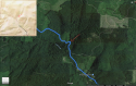
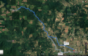
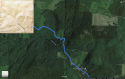
I am dropping a Googlemap map pin for the intersection of the first major spur road after Turner Creek Road turns to gravel. Use the Measure Distance tool on Google Maps and you will find that this location is about 10 kilimeters as the crow flies from the Wolfe Lair on Phillips road.

Dropped pin
Near Unnamed Road, Yamhill, OR 97148
Google Maps

This spur road leads uphill and to the EAST from Turner Creek road. If you browse in Satellyte view, you will notice that this spur road branches out into a network of private logging roads and ATV trails that interconnect or come close to interconnecting with spur roads off of Mount Richmond road which is gravel. Take Mt Richmond Rd to Gerrish Valley road, which is gravel SE and you reach Pleasant Smith rd, Oak Hill rd, Bishop Scott rd, Lillac Hill rd and Russel Creek rd, that are all gravel except for a portion of Russell Creek. The powerline trail off of Russell Creek intersects with a trail from the end of Phillps road.

My theory is that MW brought Karissa and Billy to his house, either dead or alive (Based on the extensive search by LE with divers, I believe that he killed them in the Hopewell area leaving behind suffecient physical evidence to convince an ME that they were dead. The murder weapon for Karissa was a firearm which was no doubt in that backpack MW was carrying when he returned to Cascade Steel. This firearm was disposed of in the furnace at Cascade Steel.) MW then stopped at Cascade Steel briefly before taking the bodies to his home.

Sometime in the next few nights, MW loaded the bodies of KF and WF on his ATV then drove up Phillips road to take trails and gravel roads up into the Weherhouser Timber land between Mount Richmond Rd and Turner Creek Rd. MW then disposed of their bodies at this location.

IIRC, LE mentioned that the bodies were covered with a tarp. This was probably MW's attempt to get rid of the tarp that he had wrapped them in rather than hide the bodies. Given the statements by LE that Karissa had died from agun shot wound to the head, I suspect that MW expected that their bodies would not be recognizable as human to an untrained person.

Given this scenario, there would have been at least traces of blood everywhere that MW took KF and WF.
 
  • #1,011
August 5th at 9:30 is the next.
 
  • #1,012
  • #1,013
Preserve evidence and wait for testing results?
 
  • #1,014
  • #1,015
It's this bump in the road that was my marker for seeing where the search area was. You can see it (barely) on the DA's map at the center of the square search area. According to him, his line on his map shows where pavement ends and gravel begins. What "spur road" he's talking about I don't know. Where a gate would be I don't know. We only know that this would be an area used for recreation by MW (fishing, camping, chopping wood). I would expect it to have a water source. Is Turner Creek big enough for fish?
 

Attachments

  • fretwellmap4.png
    fretwellmap4.png
    1.3 MB · Views: 9
  • #1,016
It's this bump in the road that was my marker for seeing where the search area was. You can see it (barely) on the DA's map at the center of the square search area. According to him, his line on his map shows where pavement ends and gravel begins. What "spur road" he's talking about I don't know. Where a gate would be I don't know. We only know that this would be an area used for recreation by MW (fishing, camping, chopping wood). I would expect it to have a water source. Is Turner Creek big enough for fish?
Looks like it:

Turner Creek Reservoir Fishing near Carlton, Oregon | HookandBullet.com
 
  • #1,017
Michael Wolfe in court on charges of kidnapping, murder of Karissa Fretwell and son
Michael Wolfe, a Gaston man accused of kidnapping and murdering Karissa Fretwell and son Billy, had a brief court hearing Wednesday, where attorneys presented the judge with procedural requests.

Wolfe appeared via video screen during the hearing scheduled at 1:10 p.m. at the Yamhill County Courthouse. Judge Cynthia Easterday presided.

Defense attorneys John Sweeny and Dianna Gentry filed a motion to preserve evidence and notify Wolfe of testing.

[...]

At Wednesday's hearing, Sweeny and Gentry were granted a hearing to argue to not use restraints during hearings while Wolfe is in the courtroom. The hearing is scheduled for 9:30 a.m., Aug. 5.

PHOTOS: Michael Wolfe appears in court via video call in murder of Karissa Fretwell, son
 
  • #1,018
I would point out to everyone this recently logged area just to the East of the bend in the road on the DA's map.

Dropped pin
Near Yamhill County, OR
Google Maps

This area is more passable on an ATV than mature forest.

I just checked GoogleMaps navigation to confirm my memory that it is about a half hour drive from my place to where the DA's map indicates where the bodies were found. It is about the same drive time from the Wolfe lair. Going cross country on an ATV might be faster but definately not a lot slower.
 
  • #1,019
Going cross country on an ATV might be faster but definately not a lot slower.

I don't see him riding an ATV with 2 dead bodies along for the ride. Especially in that terrain. I can see him going up hill and woopsie, dead body fell out. I imagine he probably had a 4 wheel rig with a bed.

Doesn't matter now how he got them there. I was only curious about the gate because the area was searched before and if the gate had been closed, SAR might not have gone there, thinking the general public would also be confronted by the gate. I know that often, regular permitted users get keys to gates. I've been issued them before. Did he have a key to a gate and was the bodies behind that gate? Again, this doesn't really matter. We have the bodies now.
 
  • #1,020
He does have a small pickup. Whether it's 4 wheel drive I don't know.

There's so much we don't know yet. I'm assuming that since he was charged with kidnapping that there is evidence they were alive when they left the apartment. Some have speculated that their deaths occurred in Hopewell. Some that it occurred on his property in Gaston. Some wonder if he didn't somehow take them to where they were found and do it. LE claimes "an ever growing mountain of evidence" but aren't saying what that is and where they found it. I guess we're going to have to wait for trial for any of this to make sense.
 
Status
Not open for further replies.

Members online

Online statistics

Members online
118
Guests online
1,718
Total visitors
1,836

Forum statistics

Threads
632,359
Messages
18,625,275
Members
243,110
Latest member
dt0473
Back
Top