TX TX-Hunt, Overnight flooding at Camp Mystic, all girls camp. Unknown number of missing. July 4, 2025

  • #81
I saw in one article that the older girls at the camp were at a higher elevation in an area known as Senior Hill and the youngest girls closest to the river.

“Elinor Lester, 13, said she was evacuated with her cabinmates by helicopter after wading through floodwaters. She recalled startling awake around 1:30 a.m. as thunder crackled and water pelted the cabin windows. Lester was among the older girls housed on elevated ground known as Senior Hill. Cabins housing the younger campers, who can start attending at age 8, are situated along the riverbanks and were the first to flood, she said.“
Texas families plead for information on at least 23 girls missing from summer camp after floods

I’m wondering about the rationale for housing the youngest, 8 and 9 year olds, closest to the river. I’m not trying to cast blame or aspersions, just wondering about the reasons. It seems that the youngest girls would need the most assistance in an emergency or evacuation scenario and am curious about the location of evacuation routes. Obviously, there has not been this kind of catastrophic flooding in decades, but is minor flooding a regular thing? If the camp is rebuilt, I don’t think there will be cabins near the river in the future.

This is such a horrible tragedy and my heart goes out to all the families who have lost loved ones and all the families waiting for some kind of answer. I hope at least some of the missing can be found and safely rescued.
I can't speak to this setup, but way back when I was in camp, the older girls were in their own "zone", usually overlooking everyone else if the terrain was hilly. Kind of like you had reached a "higher level" for being older. We only had a lake, but the cabins were nowhere near it. Who needs a child getting up to use a restroom in the night and falling into the water? But if the water rose so quickly in this case, it's possible the girls were not originally all that close to the river, just closer than the girls on the hill.
 
  • #82
I saw in one article that the older girls at the camp were at a higher elevation in an area known as Senior Hill and the youngest girls closest to the river.

“Elinor Lester, 13, said she was evacuated with her cabinmates by helicopter after wading through floodwaters. She recalled startling awake around 1:30 a.m. as thunder crackled and water pelted the cabin windows. Lester was among the older girls housed on elevated ground known as Senior Hill. Cabins housing the younger campers, who can start attending at age 8, are situated along the riverbanks and were the first to flood, she said.“
Texas families plead for information on at least 23 girls missing from summer camp after floods

I’m wondering about the rationale for housing the youngest, 8 and 9 year olds, closest to the river. I’m not trying to cast blame or aspersions, just wondering about the reasons. It seems that the youngest girls would need the most assistance in an emergency or evacuation scenario and am curious about the location of evacuation routes. Obviously, there has not been this kind of catastrophic flooding in decades, but is minor flooding a regular thing? If the camp is rebuilt, I don’t think there will be cabins near the river in the future.

This is such a horrible tragedy and my heart goes out to all the families who have lost loved ones and all the families waiting for some kind of answer. I hope at least some of the missing can be found and safely rescued.

I’m here in Texas, have attended camps and camped in this area, and also been a counselor since the 1970’s and my daughter and her friends have attended camps in this area, and my son and his friends worked as teens at camps in this area. Not ever do I remember water this high here.
Hearing reports of the river being 2nd highest historical level

It seems it was 1991 or near there Canyon Lake rose and the Guadelupe River rose high, with flooding near San Marcos, Martindale, New Branfels, and which is east of this area of Texas.

Please understand this is a historical flash flood- it is not an expected event or an event anyone would imagine to take place.
Some of these areas have not flooded during the over 100 years since they have been founded.
While others do flood regularly- but there are warnings when rainfall is high.
The water rose over 25 feet in a matter of minutes, RVs, campers in tents, and roads washed away.

I’m seeing reports of water rising 26 feet in what were dry rivers in 45 minutes.
Monitoring and Warning System?
What I’m unsure about is a warning system, did they not see that rain was falling at a high rate in the areas feeding the rivers? There are monitoring systems all along these areas- as they are a system of rivers and aquifers and lakes for water storage for cities. Someone should have been monitoring rainfall! Could it be that monitoring was off line due to the July 4 holiday?

Yes, it is a tragedy, I know many children families who send their kids to camps in this area of Texas.
This area of flooding is huge- many families will be camping through the holiday weekend.
Prayers for all!

IMO
 
Last edited:
  • #83
More information about the camp:


Camp Mystic is a private Christian summer camp for girls, located 18 miles northwest of Kerrville on the banks of the Guadalupe River in Texas. It sits among cypress, oak and pecan trees and aims to provide young girls with a “wholesome Christian atmosphere” to develop self-esteem and personal qualities, according to the camp website.


Girls can attend the camp after they complete second grade and while on-site can choose from 30 activities including aerobics, archery and arts and crafts. Religious services are also held, with devotionals on Sunday morning on the banks of the Guadalupe River.
There were more than 700 children at the camp when the flooding took place and the majority evacuated to higher ground, Texas Lt. Gov Dan Patrick (R) said Friday.


  • #84
  • #85
Water can rise unbelievably fast with little or no warning. A few years ago I was camping with a friend, we set up our tent near a small creek that was no more than five feet across.

On the last morning of our trip we decided to go for breakfast at a nearby restaurant, and we debated whether we should pack up our tent before we went to breakfast or after. We decided to pack up our tent then we went to eat.

While at breakfast it suddenly started raining very hard, and when we drove back the entire area was flooded with very fast rushing water that was full of large branches and other debris. If we hadn’t packed our supplies we would have lost everything. We watched from a main road that was next to the little creek that we had camped near.

It was just unbelievable that the small creek of still water in front of our campsite had turned into a flash flood in less than an hour.
 

Attachments

  • IMG_2045.webp
    IMG_2045.webp
    329.5 KB · Views: 166
  • #86
The Mayor or City Manager of Kerrville spoke at the Pressor - he commented that he went for a run at 3:00 AM, it was lightly raining at that time. By 5:00 AM, he said the lower portion of a park was under water. It sounds like it happened very quickly.

But it's the job of local & state emergency services to proactively alert & issue warnings. I'm giving these officals a hard side eye, but waiting for more specific weather information to come out. Right now, it's about search & rescue, and unfortunately recovery.

Local News KSAT 12 San Antonio- Live with weather reports and footage July 5 6AM

I lived in this area for 20 years, during college, and worked for Texas Parks and Wildlife part of that time- we did fish studies in streams, rivers, and lakes during flood seasons.

Yes, flooding is not uncommon, but this water level is exceptionally high, and rising very fast.
There are monitoring stations checking all of these things
- Rainfall levels for drainage areas
- River levels
- Lake levels
- Aquifer levels
- Water height at bridges
What has to be considered is the level of Canyon Lake- reported only 40% full.
What rainfall is forecasted for the rest of this weekend and next week? The ground is saturated
Guadelupe River Basin is huge- has to be 200-300 miles long- It begins northwest of Kerr County and flows through Canyon Lake and then down to the Gulf of Mexico.

Reported this morning
Guadelupe River receding
Spring Branch water level rose to crest (highest point before receding) at 30 feet overnight
Colorado River flooding headed to Austin- weather forecasts more rain
Burnet flooding currently
San Antonio light rain
Considerations
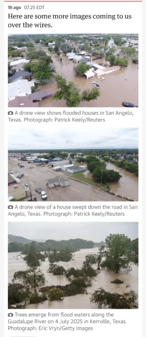
Debris coming down river, downed trees, roads flooded or covered in debris, cleanup crews

All the different entities for monitoring and emergency warning systems must communicate.
Surely this was happening?!
Were there warnings?
If there were warnings- did people just simply ignore them?
Did something knock out communication systems?

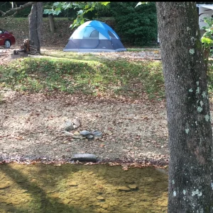
I’m just as confused and concerned- no way the death toll can’t rise. It is a holiday weekend, prime time for families to be camping
Prayers for all

IMO
 
Last edited:
  • #87
“My 9-year-old on the flats was woken up by a friend, water coming into the cabin, and their counselors saved all those girls’ lives. They broke windows to get them out the back of the cabin and back towards cabins that line up towards an embankment that goes all the way up to Sky High, where the Mystic sign is. And the girls ended up climbing all the way to Sky High. Half of them had no shoes on, but they were safe.”

 
  • #88
Water can rise unbelievably fast with little or no warning. A few years ago I was camping with a friend, we set up our tent near a small creek that was no more than five feet across.

On the last morning of our trip we decided to go for breakfast at a nearby restaurant, and we debated whether we should pack up our tent before we went to breakfast or after. We decided to pack up our tent then we went to eat.

While at breakfast it suddenly started raining very hard, and when we drove back the entire area was flooded with very fast rushing water that was full of large branches and other debris. If we hadn’t packed our supplies we would have lost everything. We watched from a main road that was next to the little creek that we had camped near.

It was just unbelievable that the small creek of still water in front of our campsite had turned into a flash flood in less than an hour.

Yes I’m seeing footage of homes that were built 50, 80, 100 years ago that are now swept off foundations.
Oak trees that must be 80 years old or more- and do not live along river banks- swept away.
I remember flooding on Canyon Lake in late 1980’s- I was living a hundred yards from Canyon Lake at the time. The entire lake park was under water up to right behind the Dairy Queen. Water was released downstream

Updates Kerr County showing water rising, depth, and weather forecast
Water flowing to Canyon Lake and will be held- lake is only 40%, flood waters will not flow downstream toward New Branfels

KSAT 12 July 5 6:30AM- link
I fear the number of missing will continue to rise, so very sad
IMO
 
Last edited:
  • #89


KERRVILLE, Texas (AP) — Texas parents frantically posted photos of their young daughters on social media with pleas for information as at least 23 campers from an all-girls summer camp were unaccounted for Friday after floods tore through the state’s south-central region overnight.
 
  • #90

Attachments

  • IMG_4119.webp
    IMG_4119.webp
    76.6 KB · Views: 155
  • #91
More information about the camp:


Camp Mystic is a private Christian summer camp for girls, located 18 miles northwest of Kerrville on the banks of the Guadalupe River in Texas. It sits among cypress, oak and pecan trees and aims to provide young girls with a “wholesome Christian atmosphere” to develop self-esteem and personal qualities, according to the camp website.


Girls can attend the camp after they complete second grade and while on-site can choose from 30 activities including aerobics, archery and arts and crafts. Religious services are also held, with devotionals on Sunday morning on the banks of the Guadalupe River.
There were more than 700 children at the camp when the flooding took place and the majority evacuated to higher ground, Texas Lt. Gov Dan Patrick (R) said Friday.


There are many many boys and girls camps in the Hill Country area of Texas
Children’s age would be 8-12 years, other camps are for teens 14-18 years
Counselors and camp workers are teenagers 14-18 years old

Texas Hill Country- MAP showing river basins
Guadalupe River Basin
Areas flooding Hunt to southeast- purple area on map
Mystic Camp- 23 girl campers still missing
La Junta boys camp flooded- none missing
Kerrville HS soccer coach missing, him and his wife and two young children- camping
Older couple Robert and Johnnie Brake- still missing- camping

Water is headed southeast to Canyon Lake- khaki green area of map
The river becomes wider and deeper faster as it moves downstream- then Guadalupe flows into Canyon Lake- water southeast in Guadalupe River comes from spillway of Canyon Lake and flows to the Gulf of Mexico

Colorado River Basin
Flooding also occurring near Burnet Texas- salmon colored area northwest of Austin
Water from Burnet flows to Lake Austin, Lake Travis- in Austin
Colorado continues to Bay City to Gulf of Mexico

IMO
 
Last edited:
  • #92
  • #93
  • #94
This is absolutely terrifying. Mother Nature has a way of writing her own horror scripts.
I’m praying for exhausted, dirty and lost folks to be rescued safely today :(
 
  • #95

City of Kerrville will hold 10 am press conference today.
 
  • #96
There are many many boys and girls camps in the Hill Country area of Texas
Children’s age would be 8-12 years, other camps are for teens 14-18 years
Counselors and camp workers are teenagers 14-18 years old

Texas Hill Country- MAP showing river basins
Guadalupe River Basin
Areas flooding Hunt to southeast- purple area on map
Mystic Camp- 23 girl campers still missing
La Junta boys camp flooded- none missing
Kerrville HS soccer coach missing, him and his wife and two young children- camping
Older couple still missing- camping

Water is headed southeast to Canyon Lake- khaki green area of map
The river becomes wider and deeper faster as it moves downstream- then Guadalupe flows into Canyon Lake- water southeast in Guadalupe River comes from spillway of Canyon Lake and flows to the Gulf of Mexico

Colorado River Basin
Flooding also occurring near Burnet Texas- salmon colored area northwest of Austin
Water from Burnet flows to Lake Austin, Lake Travis- in Austin
Colorado continues to Bay City to Gulf of Mexico

IMO

4 Zone Weather 18 hours ago- timestamp about 1 min
Guadalupe River, Medina River

Above reports from yesterday at time stamp 1 min- that the river gauges may have been destroyed or not measuring, meteorologist is describing measurements are old- the gauges stopped updating
Hunt gauge on Guadalupe River
Medina river gauge at- not sure location
This makes more sense now- it seems monitoring systems didn’t work

How terrifying!
IMO
 
Last edited:
  • #97
This is so horrific and terrifying for all involved. Without victim blaming, I do ask how this occurred at a campsite like this? Was there not enough warning of how bad the weather was going to be? Was it deemed not necessary to evacuate? I understand there were a large number of campers involved, but management need a comprehensive emergency plan to suit. I'm just trying to understand how it got to this point.
I don’t know the exact situation here, but I know from experience that catastrophic flooding can occur with little to no warning. I live in eastern South Carolina, and we had such an event in 2015. Hurricane Joaquin added a ton of moisture into the Gulf Stream even though it never made landfall in the U.S. There was no reason for us to be concerned about Joaquin, but a high pressure system appeared out of nowhere off the coast and then a third high pressure system in the north stalled its movement. The coastal storm was able to quickly pull in massive amounts of moisture from the warm ocean water, as well as the remnants of Joaquin and the northern storm system, and it turned into the perfect storm overnight. Torrential downpours fell on South Carolina for 2-3 days. Forecasters predicted there would be heavy rain, but they didn’t know the system would stall out for days. Nearly 20 dams broke all across the state and parts of the interstate were completely washed out. The whole situation was incredibly shocking. Especially for inland communities. Their dams simply could not withstand the amount of water that overwhelmed them when the Waccamaw and Pee Dee rivers flooded.

My heart is breaking so much for this community and the families of those missing or killed. 💔
 
Last edited:
  • #98
This is a tragic event that’s about to escalate into a large scale recovery operation. The conditions appear to be worst-case, fast-moving floodwaters, debris choked terrain, and dispersed scent profiles that will severely challenge recovery teams. imo
 
  • #99
I don’t know the exact situation here, but I know from experience that catastrophic flooding can occur with little to no warning. I live in eastern South Carolina, and we had such an event in 2015. Hurricane Joaquin added a ton of moisture into the Gulf Stream when it made landfall (I think in Texas, actually). There was no reason for the east coast to be concerned about Joaquin, but a high pressure system appeared out of nowhere off the coast and then a third high pressure system in the north stalled its movement. The coastal storm was able to quickly pull in massive amounts of moisture from the warm ocean water, as well as the remnants of Joaquin and the northern storm system, and it turned into the perfect storm overnight. Torrential downpours fell on South Carolina for 2-3 days. Forecasters predicted there would be heavy rain, but they didn’t know the system would stall out for days. Nearly 20 dams broke all across the state and parts of the interstate were completely washed out. The whole situation was incredibly shocking. Especially for inland communities. Their dams simply could not withstand the amount of water that overwhelmed them when the Waccamaw and Pee Dee rivers flooded.

My heart is breaking so much for this community and the families of those missing or killed. 💔

This is the best coverage I’ve seen showing how the rain and water levels moved along the Guadalupe River from early hours of Friday to this morning
KSAT abc 12 LIVE Sat July 5 9AM- meteorologist begins at timestamp 5:30

Terrifying
IMO
 
  • #100
"Camp Mystic’s cost has been reported as being more than $4,300 per camper, and other camps advertise prices as high as $6,300 for a four-week session."


"The deadly flooding that hit Kerrville on July Fourth stirred memories of a similar disaster nearly 40 years earlier. It happened on the morning of July 17, 1987. In all, 43 teenagers and adults were swept into the water. Thirty-three were rescued. Nearly 300 children from Seagoville Baptist Church in Balch Springs, near Dallas, had spent the week at the camp."

So, not the first time that it happened at the camp. I always account for the human mentality, "unless it happens, it is next to impossible". But it did happen before in this location.
 

Members online

Online statistics

Members online
151
Guests online
1,338
Total visitors
1,489

Forum statistics

Threads
632,312
Messages
18,624,580
Members
243,083
Latest member
Delmajesty
Back
Top