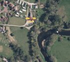
On a different note, I did a bit of sleuthing the other night, and I noticed something odd on Google Maps.
There is a property about a mile north of the riverside walk where NB went missing which has some odd features:
1. It has an elaborate suspended footbridge over the river, closed off to the public.
2. A large plot of land with very tall gates and "private property" keep out signs
3. It shares a very well built and neat retaining wall with parts of the Rowanwater development
4. The plot of land has access to a track that runs besides the river. This track pretty much runs all the way down to the point where NB was last seen.
Things I find odd about this:
a) It's a very elaborate bridge for it to be a private bridge. If it's there for a simple purpose, why is it so elaborate? It suggests it wasn't always private and possible once upon a time part of a public path. It's now gated off (see pictures) to prevent people accessing what is private land. It's not a bridge for vehicles, so it would never have been for farming or anything like that. There's a footpath on the other side of the river - so my hunch is that originally this bridge was put in place to serve as a crossing point for people walking beside the river - at some point the land has been bought and the footpath closed off.
b) It's a large plot of land, and the shared retaining wall with Rowanwater suggests there is some kind of link between the owners of the house/land and the owners of Rowanwater. Are they the same people? Was the land that Rowanwater is built on previously owned by the people who own the house?
c) The track/pathway appears to be private solely because there don't appear to be any public access points to it - but it would surprise me if you couldn't access this path from the 'upper field' near where NB was last seen. The path/track appears to be well trodden from satellite imagery both both foot and vehicles. The only vehicular access to the track is from the property mentioned above. At a certain point, the track appears to turn in to a slipway in to the river (highlighted in blue). Look at the track/path - they are clearly regularly used by vehicles.
View attachment 401839
View attachment 401840
View attachment 401844


 www.mirror.co.uk