“Per LE the bike was still on the back of the truck. Uncertain if she had the keys.”
What are your thoughts at this point,
@montanagirl15?
My thoughts are, and always have been, that this is a case about Geography, Topography, etc...this is all about terrain, mapping, etc..Moo.
What comes to mind is CUE, SAR group, iirc it was CUE ( hi
@Foxfire ) during the search for Heather Elvis. Iirc the searchers had GPS trackers on. They were able to, at the end of the day, look at a screen and see ExActly where they searched, and what areas may have been missed.
I’m sure LE has all resources out. I’m very interested about who all is out right now and in what capacity.
I would like to know from LE what is the scale of their search right now. They’ll likely start within a mile radius and work their way out, etc, etc...
She’s been out there 35 days but miracles do happen. Time really is of essence. I’m not ready to give up yet.
One concern is if they are tracking dogs, the trail could be contaminated/compromised if too many people are out there searching. So this is always a catch 22 with getting searchers out there vs. keeping it clean for the dogs.
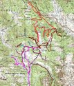
Phot0 1 I've included is the map that Sweetwater Now posted in their article on July 17th
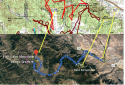
Photo 2 is a screen shot of a map from KUTV News that I added points to in order to compare to the search and rescue map I put it over and drew lines to their intersects.
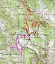
Photo 3 is MY OPINION of where the truck was found based on the personal comparison of these two maps. If it was an untraveled road it looks like it was SO close to where they initially searched. I don't know what the terrain looks like, since I've never been there, but the close ups of Google Maps shows very few dirt roads and a lot of open space and a lot of trees.
Anyway. It was bugging me what the comparison would be between the two maps so I thought I'd share what I found.
Photo 1(Press-Release-map-231019)-
Official Search and Rescue Mission for Aubree Corona Suspended
Photo 2(Capture2)
Car found of the missing Wyoming woman, last seen in July
These maps are INSANE. Man.
(Same images we’ve seen that Montangirl and AmandaRW posted)
ETA: That is one big green blob for lack of a better term. And a bunch of squiggly lines. Sigh.
ETA2:
“A map of Tip Top Search and Rescue members’ tracks during the search. This does not include efforts from SCSO and Fremont County Operations. Photo Courtesy of Tip Top Search and Rescue”
——
EYA3:
So “Tip Top SAR”...I missed that.
Tip Top Search and Rescue