2023 Hurricane and Tropical Weather

DNA Solves
DNA Solves
DNA Solves

View attachment 447925

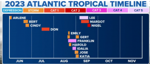
Nigel’s winds have increased to 80 mph, with higher gusts. Meteorologists said Nigel is forecast to rapidly strengthen into a major hurricane on Tuesday. It could start weakening late Wednesday.

As of Monday’s forecast, the NHC has Nigel staying out to sea.
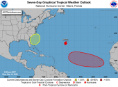
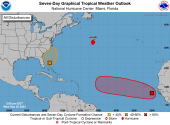
I'm more interested in that yellow blob on the map, being in NC! And the red blob may end up with a curve north/northeast similar to Nigel. BBM below.

1695082500299.png
Tropical Weather Outlook
NWS National Hurricane Center Miami FL
800 PM EDT Mon Sep 18 2023

For the North Atlantic...Caribbean Sea and the Gulf of Mexico:

Active Systems:
The National Hurricane Center is issuing advisories on Hurricane
Nigel, located over the central subtropical Atlantic.

1. Eastern Tropical Atlantic: (red blob)
A tropical wave is expected to move off the west coast of Africa by
Wednesday. Environmental conditions are forecast to be conducive
for gradual development of the wave thereafter, and a tropical
depression is likely to form late this week or this weekend while
the system moves westward across the eastern and central tropical
Atlantic.
* Formation chance through 48 hours...low...near 0 percent.
* Formation chance through 7 days...high...70 percent.

2. Western Atlantic: (yellow blob)
A non-tropical area of low pressure is forecast to form near the
southeastern coast of the United States late this week. This system
could acquire some subtropical characteristics this weekend if it
remains offshore while it moves generally northward.
* Formation chance through 48 hours...low...near 0 percent.
* Formation chance through 7 days...low...30 percent.

Forecaster Brown
 
Re: yellow blob


A low will form off the Southeast coast late this week. Computer models forecast a swirl of low pressure will form along an old front somewhere off the coast of eastern Florida, Georgia or the Carolinas late this wee

If this low can remain over the warm Gulf Stream long enough, it could sprout enough thunderstorms to warm it sufficiently to be considered a subtropical depression or storm. These are a mix of lows associated with fronts, but also have some qualities of tropical storms. The National Hurricane Center issues advisories for these subtropical systems as they do for tropical depressions and storms.
 
DCT_SPECIAL6_1280x720.jpg
From link above:

A new tropical wave that has just emerged from Africa is likely to become a tropical depression by this weekend, according to the National Hurricane Center. Assuming it holds together, it will still remain far from land through the first half of next week. It remains to be seen whether it will ever threaten land, or curl out over the open Atlantic Ocean as Nigel will do.

The next named storms in the Atlantic hurricane season will be named "Ophelia," then "Philippe."
 

BOSTON (AP) — When it comes to hurricanes, New England can’t compete with Florida or the Caribbean.

But scientists said Friday that the arrival of storms like Hurricane Lee this weekend could become more common in the region as the planet warms, including in places such as the Gulf of Maine.

One recent study found climate change could result in hurricanes expanding their reach more often into mid-latitude regions, which includes New York, Boston and even Beijing. Factors in this, the study found, are the warmer sea surface temperatures in these regions and the shifting and weakening of the jet streams — strong bands of air currents that encircle the planet in both hemispheres.

“These jet stream changes combined with the warmer ocean temperatures are making the mid latitude more favorable to hurricanes,” Joshua Studholme, a Yale University physicist and l ead author on the study. “Ultimately meaning that these regions are likely to see more storm formation, intensification and persistence.”

(more at link)
 
I'm more interested in that yellow blob on the map, being in NC! And the red blob may end up with a curve north/northeast similar to Nigel. BBM below.

View attachment 447939
Tropical Weather Outlook
NWS National Hurricane Center Miami FL
800 PM EDT Mon Sep 18 2023

For the North Atlantic...Caribbean Sea and the Gulf of Mexico:

Active Systems:
The National Hurricane Center is issuing advisories on Hurricane
Nigel, located over the central subtropical Atlantic.

1. Eastern Tropical Atlantic: (red blob)
A tropical wave is expected to move off the west coast of Africa by
Wednesday. Environmental conditions are forecast to be conducive
for gradual development of the wave thereafter, and a tropical
depression is likely to form late this week or this weekend while
the system moves westward across the eastern and central tropical
Atlantic.
* Formation chance through 48 hours...low...near 0 percent.
* Formation chance through 7 days...high...70 percent.

2. Western Atlantic: (yellow blob)
A non-tropical area of low pressure is forecast to form near the
southeastern coast of the United States late this week. This system
could acquire some subtropical characteristics this weekend if it
remains offshore while it moves generally northward.
* Formation chance through 48 hours...low...near 0 percent.
* Formation chance through 7 days...low...30 percent.

Forecaster Brown
Me too! I live on the southeast coast of NC.
 

The second area that we are watching is very close to the Carolina coast. If any intensification happens it would likely take place on either Friday or Saturday of this week. It is debatable whether it would become a named storm, but there is near certainty that there will be some heavy rain rolling up the east coast possibly reaching coastal New England later this weekend.
 

The second area that we are watching is very close to the Carolina coast. If any intensification happens it would likely take place on either Friday or Saturday of this week. It is debatable whether it would become a named storm, but there is near certainty that there will be some heavy rain rolling up the east coast possibly reaching coastal New England later this weekend.
Unbelievable. I have lived in FL for 25 years, moving back to CT next year and the hurricanes are following me. argh!
 
650c4800cfcff.image.png

A tropical wave just west of Cabo Verde is likely to become the Atlantic's next named storm as it moves west through conducive environmental conditions.

NHC forecasters expect the wave, which is producing disorganized showers and thunderstorms, to become a tropical depression over the weekend or early next week as it moves across the eastern and central tropical Atlantic at around 10 to 15 mph. The wave has a 70% chance of forming within the next seven days.

While it's too soon to tell whether the disturbance will impact the Gulf of Mexico, local meteorologists said this week that early modeling shows the system veering out to sea and avoiding the U.S. entirely, despite its current path west.
 
I just received a high wind alert for my area all the way up here for this weekend.

URGENT - WEATHER MESSAGE
National Weather Service Mount Holly NJ
942 AM EDT Thu Sep 21 2023

Delaware Beaches-Atlantic Coastal Cape May-Coastal Atlantic- Coastal Ocean- Including the cities of Rehoboth Beach, Ocean City, Atlantic City, and Long Beach Island 942 AM EDT Thu Sep 21 2023

...HIGH WIND WATCH IN EFFECT FROM LATE FRIDAY NIGHT THROUGH SATURDAY EVENING...

* WHAT...Northeast winds 25 to 40 mph with gusts up to 60 mph possible.

* WHERE...In Delaware, Delaware Beaches. In New Jersey, Atlantic Coastal Cape May, Coastal Atlantic and Coastal Ocean.

* WHEN...From late Friday night through Saturday evening.


A non-tropical low-pressure system is expected to form within a large area of disorganized showers and thunderstorms to the east of the Florida Peninsula by early Friday, the NHC said. This system could acquire some subtropical characteristics on Friday or early Saturday while it moves generally northward toward the coast of North Carolina.

Regardless of development, the NHC said Invest 99L is likely to bring gusty winds to gale force, heavy rain and high surf to portions of the Southeast and mid-Atlanticon Friday and into this weekend.


144938_5day_cone_with_line_and_wind.png

Elsewhere in the Atlantic, the NHC said Tropical Depression Seventeen formed, and is likely to spin up into Tropical Storm Phillipe as early as today.

As of 11 a.m., TD 17 was located about 985 miles west of the Cape Verde Islands moving west at 15 mph with sustained winds of 35 mph.

“This general motion with a slight decrease in forward speed is expected during the next few days,” forecaster said. “Very gradual strengthening is expected through early next week.”

It’s forecast to move generally westward at 10 to 15 mph for the next few days, and then turn west-northwestward or northwestward starting Tuesday gaining in strength but become a hurricane.
 

Members online

Online statistics

Members online
143
Guests online
3,044
Total visitors
3,187

Forum statistics

Threads
604,157
Messages
18,168,399
Members
232,058
Latest member
queencity
Back
Top