
Install the app
How to install the app on iOS
Follow along with the video below to see how to install our site as a web app on your home screen.
Note: This feature may not be available in some browsers.
You are using an out of date browser. It may not display this or other websites correctly.
You should upgrade or use an alternative browser.
You should upgrade or use an alternative browser.
CANADA - Lucas Fowler, Chynna Deese, and Leonard Dyck, all murdered, Alaska Hwy, BC, Jul 2019 #7
- Thread starter Strangeworld
- Start date
Welcome to Websleuths!
Click to learn how to make a missing person's thread
Click to learn how to make a missing person's thread


- Status
- Not open for further replies.
tmar
Well-Known Member
- Joined
- Jun 3, 2017
- Messages
- 5,696
- Reaction score
- 49,937
Many people are very anxious about these 2 criminals being caught.
Imagine how they are now feeling.
No amount of game playing, training could have prepared them for what they are now encountering.
Surely when they hear "POLICE. STOP", they will 'give up' peacefully, as they realize death is not what they want.
Imagine how they are now feeling.
No amount of game playing, training could have prepared them for what they are now encountering.
Surely when they hear "POLICE. STOP", they will 'give up' peacefully, as they realize death is not what they want.
CanadianMade
Former Member
- Joined
- Jul 28, 2019
- Messages
- 531
- Reaction score
- 1,667
These images are the clearest I've seen and do match up with the mysterious video that was posted earlier this evening IMO.
I'm watching that video now and the two buildings in it are kind of angled towards each other. There are also lots of trees in behind them. None of those buildings in the photo line up with the video ...to me. That's just what I am seeing. I'm not going to assume one way or the other. Just expressing my thoughts on it.
Edit: I am also very tired and words are starting come out in strange strings of non-sense so I tried to fix that a little.
Xyzzia
Well-Known Member
- Joined
- Jul 24, 2019
- Messages
- 194
- Reaction score
- 1,084
For them to travel from where the RAV4 was burnt out east of Gillam all the way backwards and south around Split lake to York landing which is approx. 200 km by road..... And by not taking the road in The Fairy and going south around the lake would definitely be bushwhacking through hell. And I might be 200 kilometers but it's 200 km a bush, brush,Thicket, Skaggs, bugs, and Wildlife some of which could eat you. That's what I was talking about beforeDont think theyd really have to 'bushwhack' though. Its no trail but its kept somewhat clear for access and stuff. Not sure about the scrag either but idk, maybe they picked a rise or dry spot (do dry spots exist up there right now lol) for the pylons.
Maybe Im just looking for the "fun" answer because "they did something totally un-interesting and just happened by luck to not be seen" seems anti-climatic after more than a week of this lol
Also its just, super direct so maybe subconsciously thats making me think it would be easier than it would be. tried to find some pics of the lines in hat area to get some idea but not much luck
")
CanadianMade
Former Member
- Joined
- Jul 28, 2019
- Messages
- 531
- Reaction score
- 1,667
if anyone can find that video again (taken down from anywhere ive checked) should post it.
I know I know
but Im actually just trying to get a closer look at york landing. Ive already told myself the videographer was just excited/confused
It's still on that news site someone mentioned earlier. At least a bit of it is. It's mixed in with the reporter talking but you can still view it....or it was an hour or so ago. I lost connection for a bit.
ETA: I know the site isn't very credible but the footage shown is part the video from earlier(original was longer by maybe 10 seconds or so).
Xyzzia
Well-Known Member
- Joined
- Jul 24, 2019
- Messages
- 194
- Reaction score
- 1,084
All thanks for the image of the hydro line. I miss that part so I got a bit confused. So yeah they could have walked at it wouldn't have been so skaggy and swampy.Dont think theyd really have to 'bushwhack' though. Its no trail but its kept somewhat clear for access and stuff. Not sure about the scrag either but idk, maybe they picked a rise or dry spot (do dry spots exist up there right now lol) for the pylons.
Maybe Im just looking for the "fun" answer because "they did something totally un-interesting and just happened by luck to not be seen" seems anti-climatic after more than a week of this lol
Also its just, super direct so maybe subconsciously thats making me think it would be easier than it would be. tried to find some pics of the lines in hat area to get some idea but not much luck
Walking that line make sense.
Thanks for posting it
sleuth3000
Well-Known Member
- Joined
- Jul 26, 2019
- Messages
- 153
- Reaction score
- 1,041
For them to travel from where the RAV4 was burnt out east of Gillam all the way backwards and south around Split lake to York landing which is approx. 200 km by road..... And by not taking the road in The Fairy and going south around the lake would definitely be bushwhacking through hell. And I might be 200 kilometers but it's 200 km a bush, brush,Thicket, Skaggs, bugs, and Wildlife some of which could eat you. That's what I was talking about before
taking the route I outlined itd be alot closer to 100km than 200km. Its a more direct route then the road by alot and they wouldnt have to use the ferry (which cost money they may not have and would include a huge risk of getting caught)
Also dont worry im not trying to convince you, Im not convinced myself! just kinda spitballin tryna figure things out while we wait
Without knowing what those lines might look like right now its just guesswork
Xyzzia
Well-Known Member
- Joined
- Jul 24, 2019
- Messages
- 194
- Reaction score
- 1,084
Haha you have me convinced though. Guess you're living up to your nametaking the route I outlined itd be alot closer to 100km than 200km. Its a more direct route then the road by alot and they wouldnt have to use the ferry (which cost money they may not have and would include a huge risk of getting caught)
Also dont worry im not trying to convince you, Im not convinced myself! just kinda spitballin tryna figure things out while we wait
Being that these were Vancouver Island boys (and being a Vancouver Islander born and bred myself) ferries would be second nature to them. It’s the only way (short of flying) we can get off our island, so all island residents are well versed in ferries. I am sure they would have taken the ferry from Split Lake to York Landing, instead of bushwhacking. They may have even found a way to sneak on so they weren’t seen.
musicaljoke
Well-Known Member
- Joined
- May 20, 2013
- Messages
- 7,316
- Reaction score
- 38,747
That is a great interview. It's heartbreaking the amount of stress and fear this manhunt must be putting on the communities. Not just the disruption of daily life, I'm sure there are questions, rumors, and possibly distrust, that neighbors are having to deal with. It has got to be particularly hard for families with children, elderly persons who may be living alone, etc. (edit, spelling)
Yes, it must be absolutely awful for the people in the community. I doubt that they even have locks on their doors, or if there was a lock at one time, the keys have never been used and are long gone.
Xyzzia
Well-Known Member
- Joined
- Jul 24, 2019
- Messages
- 194
- Reaction score
- 1,084
Yes or took the hydro line down into York Landing just as WS sleuth3000 stated.Being that these were Vancouver Island boys (and being a Vancouver Islander born and bred myself) ferries would be second nature to them. It’s the only way (short of flying) we can get off our island, so all island residents are well versed in ferries. I am sure they would have taken the ferry from Split Lake to York Landing, instead of bushwhacking.
sleuth3000
Well-Known Member
- Joined
- Jul 26, 2019
- Messages
- 153
- Reaction score
- 1,041
makes sense *in theory* but without a pic or description from someone in N canada what they might look like, hell could be a relatively easy stroll, could be a thorny marsh impossible to traverse reallly dont know.
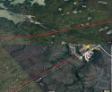
that otto mapping guy was asking me about the winter road system and when I was looking just happened to notice it and seemed such a perfect direct route
I mean the line starts RIGHT where they left the rav. Like RIGHT there. They were prolly almost under it getting out the car lol.
This theory is fun but I think walking along the road or hitching more likely
Esp with the comment about ferries being second nature, hadnt considered they might feel more at ease there than i would
Seattle1
Well-Known Member
- Joined
- Feb 25, 2013
- Messages
- 41,726
- Reaction score
- 433,728
Nine News SydneyVerified account @9NewsSyd
Canadian authorities are tonight closing in on the teen fugitives wanted for murdering Australian Lucas Fowler, his American girlfriend and a University Professor from Vancouver. @LexiDaish #9News
#9News
9 News Sydney, nightly at 6.00pm.
1:10 AM - 29 Jul 2019 pst
ETA: @ 16 seconds/1:26 embedded video news clip, Nine news is also showing a few seconds of the talked about "swat police action" shown earlier -- although it's silent and reporter makes no comment on it.
Last edited:
Xyzzia
Well-Known Member
- Joined
- Jul 24, 2019
- Messages
- 194
- Reaction score
- 1,084
Winter roads are just that used in the winter time. And the reason they can only be used in the winter time is the muskeg freezes up then you can drive on them.makes sense *in theory* but without a pic or description from someone in N canada what they might look like, hell could be a relatively easy stroll, could be a thorny marsh impossible to traverse reallly dont know.
that otto mapping guy was asking me about the winter road system and when I was looking just happened to notice it and seemed such a perfect direct route
I mean the line starts RIGHT where they left the rav. Like RIGHT there. They were prolly almost under it getting out the car lol.
This theory is fun but I think walking along the road or hitching more likely
It is summertime you can't drive on them cuz it's muskeg and swamp. Walking on some of that it's just like walking on chunky quicksand flosting Moss and you just sink and can't get out. Easy to bust the ankle or knee or leg. Or get stuck and drown.
So a winter road is just that .it's.. a trail through the muskeg that's frozen over that you can drive on in the winter.
sleuth3000
Well-Known Member
- Joined
- Jul 26, 2019
- Messages
- 153
- Reaction score
- 1,041
Winter roads are just that used in the winter time. And the reason they can only be used in the winter time is the muskeg freezes up then you can drive on them.
It is summertime you can't drive on them cuz it's muskeg and swamp. Walking on some of that it's just like walking on chunky quicksand flosting Moss and you just sink and can't get out. Easy to bust the ankle or knee or leg. Or get stuck and drown.
So a winter road is just that .it's.. a trail through the muskeg that's frozen over that you can drive on in the winter.
I meant I noticed the hydro lines when I was already looking at the map per someone request about the winter roads.
I'm not suggesting they used the winter roads for any real period of time. In addition to them being nigh impassable, they dont go anywhere. One from york goes to ilford then, no where. Could have used a combo of roads/trails, traintracks, and hydro lines but that seems even less likely
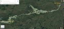
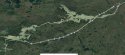
Found a few spots with decent zoom. Likely wet but I think doable. Definitely looks way clearer than anything around it by alot.
That said I'm leaning ferry now I think lol
Attachments
Xyzzia
Well-Known Member
- Joined
- Jul 24, 2019
- Messages
- 194
- Reaction score
- 1,084
Ha ... You got me thinking your theory was better than my theory and now you're thinking about changing your mind? I guess this whole situation this whole case has been like that all the way along. Anybody's guess is as good as another.I meant I noticed the hydro lines when I was already looking at the map per someone request about the winter roads. Found a few spots with decent zoom. Likely wet but I think doable. Definitely looks way clearer than anything around it by alot.
That said I'm leaning ferry now I think lol
Curious Me
Who When Where What Why & How
- Joined
- Jul 19, 2009
- Messages
- 27,475
- Reaction score
- 114,309
Many people are very anxious about these 2 criminals being caught.
Imagine how they are now feeling.
No amount of game playing, training could have prepared them for what they are now encountering.
Surely when they hear "POLICE. STOP", they will 'give up' peacefully, as they realize death is not what they want.
I'd have caved a long time ago. I love my comforts, a warm robe and slippers, some yummy food, clean sheets. No bugs either.
sleuth3000
Well-Known Member
- Joined
- Jul 26, 2019
- Messages
- 153
- Reaction score
- 1,041
Ha ... You got me thinking your theory was better than my theory and now you're thinking about changing your mind? I guess this whole situation this whole case has been like that all the way along. Anybody's guess is as good as another.
cant change a mind not made up
")
anyway I was just trying to establish possibility (was mostly curious if they could walk it in time they had) and I think I did. once you get to probability it doesnt do so well.
I mean, it looks like a nice straight direct route on the map but
-route to where? I guess where they are now but for it to be a 'direct route' that would appeal to them, wouldnt that mean they were headed to york? Nothing really else that way, except thompson in another 100 something miles lol
-looks nice on a map but would it have looked like that to them standing there? Or would it have looked like walking off the edge of the earth with little to no supplies? It is pretty clear most of the way, but if its impassable anywhere its in the first 15km
damn suns coming up, howd that happen?? lol Ima try to go to bed before it breaks the horizon. Hopefully I wake up and its all over
Last edited:
CanadianMade
Former Member
- Joined
- Jul 28, 2019
- Messages
- 531
- Reaction score
- 1,667
cant change a mind not made up
anyway I was just trying to establish possibility and I think I did. once you get to probability it doesnt do so well.
I mean, it looks like a nice straight direct route on the map but
-route to where? for it to be a 'direct route' wouldnt that mean they were headed to york? Nothing really that way, except thompson in another 100 something miles lol
-looks nice on a map but would it have looked like that to them standing there? Or would it have looked like walking off the edge of the earth with little to no supplies? It is pretty clear most of the way, but if its impassable anywhere its in the first 15km
damn suns coming up, howd that happen?? lol Ima try to go to bed before it breaks the horizon. Hopefully I wake up and its all over
That just prompted me to pay attention to the time and hey, look at that 2:47am....oops!
I think I'm up for the night. It's going to a long day tomorrow.
sleepinoz
Well-Known Member
- Joined
- Dec 26, 2012
- Messages
- 8,637
- Reaction score
- 25,383
Dont think theyd really have to 'bushwhack' though. Its no trail but its kept somewhat clear for access and stuff. Not sure about the scrag either but idk, maybe they picked a rise or dry spot (do dry spots exist up there right now lol) for the pylons.
Maybe Im just looking for the "fun" answer because "they did something totally un-interesting and just happened by luck to not be seen" seems anti-climatic after more than a week of this lol
Also its just, super direct so maybe subconsciously thats making me think it would be easier than it would be. tried to find some pics of the lines in hat area to get some idea but not much luck
If it's kept somewhat clear for access, who keeps it clear and how do they get there with their equipment?
- Status
- Not open for further replies.
DNASolves
Online statistics
- Members online
- 83
- Guests online
- 1,585
- Total visitors
- 1,668
Totals may include hidden visitors.