View attachment 56029
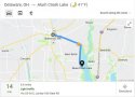
Heres a street map of Marble Cliff and Grandview Heights on the day Michael Dean Klitch disappeared.
The purple dot on the map is the home of where Michael Dean Klitch lived at on Cambridge Boulevard in Marble Cliff.
The red dot on the map is the municipal tennis courts at Goodale Boulevard and Urlin Avenue.
The black dot on the map is the Summit Chase luxury high rise apartment across the street from the municipal tennis courts at Goodale Boulevard and Urlin Avenue.
The blue dot on the map is the Grandview Swim Club at 1350 West Goodale Boulevard.
The green line on the map is the possible walking route that Michael Dean Klitch may have taken when he went from his home to the municipal tennis courts.
The yellow line on the map shows where the municipal tennis courts and the Grandview Swim Club are from each location. That is the driving route Michaels mother would have took going from the municipal tennis courts to the Grandview Swim Club.
I must point out that Interstate 70 and Interstate 670 did not exist in the west side of Columbus and outside of the Grandview Heights city limits back in 1971.
Interstate 70 only went from the Indiana Ohio border to Interstate 270 on the far west side of Columbus and east of Downtown Columbus to the Ohio West Virginia border in 1971. It wasnt until about 1975 that Interstate 70 opened from west of Downtown Columbus to Interstate 270 on the far west side of Columbus.
It wasnt until 2003 that Interstate 670 opened from west of Downtown Columbus to where it connects with Interstate 70 on the west side of Columbus.