Ruthbullock
Well-Known Member
- Joined
- Oct 27, 2016
- Messages
- 1,746
- Reaction score
- 8,763
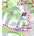
I think we have misunderstood that sign, the more rotes I have found, the more indicate it was a much shorter walk than we first thought. This version of the route takes 3hr 45 min (again a full loop) . Interestingly I have found myself drawn into finding the depths of the lac de boums aka lac de venasque. One is deeper than the others, lac superior. This isn’t the one the refuge is on and when you look at route maps it is unlikely ED was near the largest of the three lakes. However I digress, the route to the hospice I am now personally satisfied (many, many routes recorded on AllTrails, plus various blogs and DC stating it was an hour and half to the road either wayIt looks like that would be off by quite a bit. The sign at the Hospice shows 3 hours to the Port de Venasque. And ED was up yet higher by about 1/2 hour. For an extremely skilled hiker with daypack, down from the top of the Pic to the Hospice, it's 3 hours firm.
Some of my concern with the "how far could ED go before darkness" question puts the trip in an extremely high risk category. For a risk-savvy person, solo, isolated, in winter, with no need to "make miles", this should not be where the mind is going. If the mind was going there, there's something very, very, wrong, and it would be impossible to imagine where that person would end up that night.
From the refuge) was within almost grasping distance that evening and she has cycled via the hospice de France several times, over several years - so whilst she may or may not have walked up that path before- from all the photographs we have seen ED would certainly know that the final part of that pathway is very open and not steep and would be possible with a head torch.
I’m not sure that is what happened or where she went that evening, but IMO she could have continued on her journey if she wished to with reasonable confidence she would arrive safely at the hospice.