bessie
Verified Insider
- Joined
- Aug 19, 2008
- Messages
- 31,771
- Reaction score
- 1,672
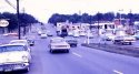
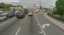
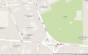
Shoney's. The "weird guy" is Adcox.Using the street view map that was posted a few days ago, I see two possible routes here.
The first one that MrTT pointed out is Kathy walking on Woodbine and then Grandview to reach her destination.
The second one is the alley between Grandview and Nolensville that ran from Thompson to Woodbine that another person suggested a few days ago.
The question here is did Grandview or the alley have any street lights back then?
If the alley didn’t have street lights, I don’t know if Kathy would have been comfortable walking on a dark alley at night.
What about Grandview and Lutie? Did those streets have street lights and sidewalks back then?
I can understand Kathy wanting to take Grandview if it was a well lit street at night and didn’t like the traffic on Nolensville.
About the area around the Nolensville-Thompson intersection, were there any nearby fast food or pizza joints back then where teens would have went to on a weekend night?
This thought just came to me. Was there any drive in theaters still open around that time of the year in the Nashville area? I’m thinking of a drive in theater that is set back from the roadway and closed for the season.
Websleuths Crime Sleuthing Community - View Single Post - SOLVED TN - Marcia Trimble, 9, Girl Scout abducted/killed delivering cookies Nashville, 1975
")