
You are using an out of date browser. It may not display this or other websites correctly.
You should upgrade or use an alternative browser.
You should upgrade or use an alternative browser.
Found Deceased TX - Rosemary Rodriguez, 54, Kilgore, 8 Oct 2019 *found deceased 2022*
- Thread starter JerseyGirl
- Start date


mlhenn
Well-Known Member
- Joined
- Jul 11, 2019
- Messages
- 16,999
- Reaction score
- 75,533
Additional links
https://www.news-journal.com/news/local/official-human-remains-found-in-gregg-county-were-woman-missing-from-kilgore-since-2019/article_001de8b6-9407-11ec-a926-3bd7e913a799.html
Autopsy confirms remains found in vehicle those of Rosemary Rodriguez
Human remains found in vehicle are those of Rosemary Rodriguez | cbs19.tv
An autopsy confirms the remains found in a vehicle in December are those of a woman missing since 2019.
Gregg County Sheriff’s Office spokesman Josh Tubb said a cause of death for Rosemary Rodriguez is still under investigation.
MAHBOOBOO
Well-Known Member
- Joined
- Jun 15, 2021
- Messages
- 209
- Reaction score
- 2,004
Dangit. RIP Rosemary.
The crazy part is that you can actually SEE her car in the woods on satellite images taken on April 2019 & September 2021.
32º26'29.57"N
94º58'24.62" W
It's especially obvious on this map. BIS Consulting Web App (bisclient.com) Click on the Basemap Gallery and choose Eagle View 2020. It's super obvious on that one. I'm gonna start using that map from here on out for everything. It's a shame that her car wasn't found earlier. I can't imagine anything worse than having a missing family member. I'd quit my job, sell everything except my vehicle and do nothing but search for the rest of my life.
Last edited:
I'm assuming the car was moved there later? I know that drones and helicopters were going over the area right after she went missing. I wonder if pictures were taken at that time? Of course, depending on the time of year the area was being being searched, trees could have still been in bloom, making the area harder to see.Dangit. RIP Rosemary.
The crazy part is that you can actually SEE her car in the woods on satellite images taken on April 2019 & September 2021.
32º26'29.57"N
94º58'24.62" W
It's especially obvious on this map. BIS Consulting Web App (bisclient.com) Click on the Basemap Gallery and choose Eagle View 2020. It's super obvious on that one. I'm gonna start using that map from here on out for everything. It's a shame that her car wasn't found earlier. I can't imagine anything worse than having a missing family member. I'd quit my job, sell everything except my vehicle and do nothing but search for the rest of my life.
MAHBOOBOO
Well-Known Member
- Joined
- Jun 15, 2021
- Messages
- 209
- Reaction score
- 2,004
I need to correct what I said, April 2019 was incorrect. I was reading the wrong date on Google Earth. The only Google Earth image on there that would be within Rosemary's missing timespan would be the Sept 9, 2021 image, and yes it shows the car. The most recent image before that was taken in 2015, which is obviously useless to us.
Can you you post a screen shot. I can't find it. Thanks.I need to correct what I said, April 2019 was incorrect. I was reading the wrong date on Google Earth. The only Google Earth image on there that would be within Rosemary's missing timespan would be the Sept 9, 2021 image, and yes it shows the car. The most recent image before that was taken in 2015, which is obviously useless to us.
MAHBOOBOO
Well-Known Member
- Joined
- Jun 15, 2021
- Messages
- 209
- Reaction score
- 2,004
SDFinColo
Former Member
- Joined
- Jul 17, 2021
- Messages
- 241
- Reaction score
- 2,121
What is the distance between where Rosemary was found and her last known location (was it the boyfriend's house)? It looks like it was a bit of a challenge to remove the car from the site, so how did the car get there? I haven't been following this case. RIP Rosemary. 
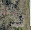
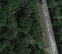
I've seen the second picture on other websites. It's odd that the headlights are on in the picture. How sure are you about that date? When I look at Google Earth, it only say Map Data 2022 Google. I'm not able to see the date it was taken. I've been assuming that the picture was taken earlier this year after her car had been located, and the car with the headlights on was possibly a member on law enforcement on the scene.The first pic is a screen shot from the mapping site I linked above. Was unable to find a date for that one.
And the second pic (with the yellow arrow) is a screen shot from Google Earth taken 9/9/21.
cvaldez1975
Well-Known Member
- Joined
- Oct 10, 2014
- Messages
- 15,682
- Reaction score
- 43,772
can you link it? i dont know how to work w coordinates ETA i saw the pix wowDangit. RIP Rosemary.
The crazy part is that you can actually SEE her car in the woods on satellite images taken on April 2019 & September 2021.
32º26'29.57"N
94º58'24.62" W
It's especially obvious on this map. BIS Consulting Web App (bisclient.com) Click on the Basemap Gallery and choose Eagle View 2020. It's super obvious on that one. I'm gonna start using that map from here on out for everything. It's a shame that her car wasn't found earlier. I can't imagine anything worse than having a missing family member. I'd quit my job, sell everything except my vehicle and do nothing but search for the rest of my life.
MAHBOOBOO
Well-Known Member
- Joined
- Jun 15, 2021
- Messages
- 209
- Reaction score
- 2,004
I've seen the second picture on other websites. It's odd that the headlights are on in the picture. How sure are you about that date? When I look at Google Earth, it only say Map Data 2022 Google. I'm not able to see the date it was taken. I've been assuming that the picture was taken earlier this year after her car had been located, and the car with the headlights on was possibly a member on law enforcement on the scene.
Headlights are not on. It's just an illusion. That's the sun reflecting off the headlights. Headlights being left on would drain the battery in about 12 hours, so that's an impossibility.
I'm positive about the date. Perhaps you are using Google Maps (the internet) instead of the actual Google Earth desktop app which has to be downloaded?
I'm curious about the building you can see in the first picture. Do you know what it is? Is it the abandoned shack you can see from the road and also how far is this from the church? I was out there a few hours after they removed the car and you can see nothing from the road back in that direction. I'm afraid to drive up the cut thru where they brought the car out.The first pic is a screen shot from the mapping site I linked above. Was unable to find a date for that one.
And the second pic (with the yellow arrow) is a screen shot from Google Earth taken 9/9/21.
What is the distance between where Rosemary was found and her last known location (was it the boyfriend's house)? It looks like it was a bit of a challenge to remove the car from the site, so how did the car get there? I haven't been following this case. RIP Rosemary.
.jpeg")
I'm curious as to why you think the car was moved there later. I have wondered about it, but it doesn't logically make sense to me given the limited details we have.I'm assuming the car was moved there later? I know that drones and helicopters were going over the area right after she went missing. I wonder if pictures were taken at that time? Of course, depending on the time of year the area was being being searched, trees could have still been in bloom, making the area harder to see.
Thanks, I don't have the app, that's why I was asking. I don't have the capability to see the date it was taken. The car appears to be sitting in a well shaded area in the 2nd picture, so I'm not sure how the sun would be shining off the headlights, but you may be right. And yes, I understand that headlights will wear down a battery and they wouldn't still be on 2 years later. I was wondering if that was Rosemary's car or perhaps someone else who happened to be in the immediate area for some unknown reason on that day.Headlights are not on. It's just an illusion. That's the sun reflecting off the headlights. Headlights being left on would drain the battery in about 12 hours, so that's an impossibility.
I'm positive about the date. Perhaps you are using Google Maps (the internet) instead of the actual Google Earth desktop app which has to be downloaded?
My only reason for thinking that it might be a possibility is that the area was searched on foot and with drones and helicopters after she went missing. If the car was in the location that is shown in the pictures, I don't know how they could have missed it.I'm curious as to why you think the car was moved there later. I have wondered about it, but it doesn't logically make sense to me given the limited details we have.
There is a rusted out abandoned looking mobile home that you can see from the road. I believe the car was located in the wooded area behind that.I'm curious about the building you can see in the first picture. Do you know what it is? Is it the abandoned shack you can see from the road and also how far is this from the church? I was out there a few hours after they removed the car and you can see nothing from the road back in that direction. I'm afraid to drive up the cut thru where they brought the car out.
Interesting! Do you live in the area? Or close by? I'm asking because I know they did searches but the only ones I saw reported were the hwy 42 bridge area and the river. I'm not questioning what you're saying. I'm thrilled to know this. Everyone local was wondering why there wasn't more searches being done. If that area was searched there's no way they could have missed it. Makes you wonder.My only reason for thinking that it might be a possibility is that the area was searched on foot and with drones and helicopters after she went missing. If the car was in the location that is shown in the pictures, I don't know how they could have missed it.
DNASolves
Online statistics
- Members online
- 120
- Guests online
- 1,850
- Total visitors
- 1,970
Totals may include hidden visitors.