In the
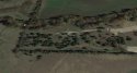
THIRD photo below of the north parking area and farther property of CCoC (North is pointing Left in photo), just beyond CCoC and into the Diamond J Ranch property, there is whitewater (far left of photo) in the North Prong Creek. There are also subdued (in this photo) dirt roads on either side of the creek that meet this whitewater point. The straight dark area across the whitewater suggests a spillway, walking bridge or maybe even a structure wide enough to drive (compare width to dirt roads on CCoC property) or perhaps a pipeline with a catwalk. The straightness to the right edge of the dark feature crossing the whitewater suggests “manmade” because nature does not produce straight lines. Enlarged, it looks like it might have pylons down into the creek bed. It could just be a small waterfall – but then why do Diamond J Ranch roads link to it as shown in the FIRST photo?
The
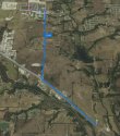
FIRST photo below is the large aerial map. For orientation, that is CCoC in the extreme right lower corner. The green lollipop is the entrance on 287 to Diamond J Ranch. Most of the dark snaking areas are creek gorges of the North Prong Creek tributaries and the large dark area is the reservoir with its dam and spillway. Perusal of the entire North Prong Creek, its tributaries and reservoirs on up the right side of this map reveals many bridges, dams, spillways, etc. The dirt roads on either side of North Prong Creek that lead directly to the whitewater section just north beyond CCoC property are more apparent on this map. Following the Diamond J Ranch road up from 287 will lead to a point where it turns right, curves and it looks like the dirt road crosses the creek to another dirt road on the other side not far from CCoC (still in the lower right third of photo) - compare to the pink hash line roads explained next.
The
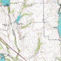
SECOND image below is the topographical map for Mid-Way Regional Airport. I was unable to locate a proper legend for the markings, but it can be compared to the large aerial map. The airport, CCoC, Rex Odom Road, SWFA, are not highlighted on this type of map although 287 cuts the lower left corner. What is of interest are the pink lines and pink hash lines (and black hash lines). I believe that pink represents the roads that either belong to the Soil Conservation District, or they are easement access roads across private ranch land. Find the words "Diamond J Ranch" on the left side. The pink solid lines
down to 287 are that Diamond J Ranch road that is prominent in aerial photos. From the words "Diamond J Ranch" to the
right are those pink hash lines – that cross right over the North Prong Creek to reach the reservoir at the words “Spillway Elev 651”.
So what appears to be a bridge on the aerial photo is in fact a bridge on the topographical map. There is no bridge or feature noted at the whitewater point near CCoC, but those dirt roads are not shown either, likely because they are private and not used by the District. Up in the left corner at the words “Riser 643” there is a definite wide dirt area on the aerial photo map (first image) wide enough for work trucks to drive across the spillway/dam.
Mid-Way Regional Airport topographical map link:
https://www.topoquest.com/map.php?lat=32.45416&lon=-96.91502&datum=nad83&zoom=4
Conclusion: We don’t know how SP arrived and departed from the CCoC, but it appears that there are some kind of bridges in very close proximity, short minutes walking, over the North Prong Creek that are passable on foot (possible at north corner of CCoC property at whitewater) and also by ATV and truck (the Diamond J Ranch road to spillway bridge) (the Riser 643 damn and spillway). The beauty of this escape route is that so many think it isn’t possible, no one was looking for someone out there in the hour after the murder, and that it avoids all those pesky cameras.


") :thinking: :banghead:
:thinking: :banghead: