Let's hope some of these just stay as a "fish spinner" and leave us humans alone.
Flhurricane.com. 3,641 likes · 2 talking about this. Welcome to the FLHurricane.com Facebook page. Hurricanes Without the Hype! Since 1995. For nearly three decades we have shared expert analysis,...

www.facebook.com
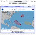
Tropical Weather Outlook
NWS National Hurricane Center Miami FL
200 AM EDT Wed Aug 31 2022
For the North Atlantic...Caribbean Sea and the Gulf of Mexico:
1. Central Tropical Atlantic:
Shower and thunderstorm activity associated with an area of low
pressure located several hundred miles east of the Lesser Antilles
has continued to increase and become more concentrated overnight.
However, recent satellite wind data indicate that the circulation
remains elongated and lacks a well-defined center. Although
environmental conditions are only marginally conducive, additional
gradual development of this system is expected and a tropical
depression is likely to form within the next couple of days. The
disturbance is forecast to move slowly toward the west-northwest,
toward the adjacent waters of the northern Leeward Islands.
Additional information on this system can be found in High Seas
Forecasts issued by the National Weather Service.
* Formation chance through 48 hours...medium...60 percent.
* Formation chance through 5 days...high...80 percent.
2. Eastern Tropical Atlantic:
A broad area of low pressure located between the west coast of
Africa and the Cabo Verde Islands is producing disorganized showers
and thunderstorms. Some gradual development is possible, and the
system could become a short-lived tropical depression over the far
eastern Atlantic during the next couple of days. By late this week,
environmental conditions are forecast to become increasingly
unfavorable for further development. Regardless, the system could
bring locally heavy rainfall to portions of the Cabo Verde Islands
through Thursday.
* Formation chance through 48 hours...low...20 percent.
* Formation chance through 5 days...medium...40 percent.
3. Central Subtropical Atlantic:
An area of low pressure is expected to form within the next day or
so along a decaying frontal zone over the central subtropical
Atlantic. Environmental conditions are expected to be conducive
for some gradual development thereafter, and a tropical or
subtropical depression could form later this week while the
system drifts generally eastward.
* Formation chance through 48 hours...low...30 percent.
* Formation chance through 5 days...medium...50 percent.
High Seas Forecasts issued by the National Weather Service
can be found under AWIPS header NFDHSFAT1, WMO header FZNT01
KWBC, and online at
ocean.weather.gov/shtml/NFDHSFAT1.php
Forecaster Brown