Austria - Thomas Plamberger leaves gf, Kerstin Gurtner to freeze to death on Austria's tallest mountain - charged with manslaughter - Jan.19/2025

  • #201
I believe Lucknerhaus parking lot must be the one they used because High Alpine Road on all the tourist sites says it is impassable Nov-May.
 
  • #202
It is possible this is where they started their climb and onto the Stüdlgrat?


[BBM]

Trail description:
Many walks start at the new "Glocknerwinkel" visitor centre at the end of the toll road to Lucknerhaus. One option is to explore the family-friendly hiking trail to the Lucknerhütte (Luckner hut) via the 'Glockner traces – mountain philosophy' trail in the Hohe Tauern National Park. From there, a mountain trail will take you across the flower strewn Speikleiten slopes, surrounded by magnificent rocky mountains and in sight of the Grossglockner, always going higher towards the Stüdlhütte (Stüdl hut) (challenging). Rangers can provide visitors with more information about other hiking opportunities in the Ködnitz valley.

Starting point:
Lucknerhaus car park (subject to charges), 9981 Kals a. Grossglockner

Arriving by public transport:
In the summer months, the National Park 'Wanderbus' goes as far as Lucknerhaus.

Level of difficulty:
Easy hike to Lucknerhütte (Luckner hut) –
Challenging from Lucknerhütte (Luckner hut) – sure-footedness necessary

Metres of climbing / walking time (to Stüdlhütte):
900 m / 6 hrs (there and back)


Opening times:
Spring to autumn

Features:
"Glocknerwinkel" visitor centre; Vegetation grown in proglacial area of glacier; mountain meadows; marmots; ibex; eagles; bearded vultures; chamois

Refreshment points:
Lucknerhaus, Lucknerhütte, Stüdlhütte

----------------

Of course that is all in the open months and not the rougher winter months.

It looks like roughly the same area as the still in the video of the hikers doing the same route except they I assume are there in the months when the visitor center is open whereas TP and KG could have simply sued the car park and the center was closed when they went for the winter.

1765843048219.webp


1765843184303.webp


Here is a video of hiking from Luckner to stüdlhütte.


Here is an account of a person who climbed via the Stüdlgrat route, starting at Luckner parking lot to Stüdlhütte (1.5 hours) then the next day from Stüdlhütte to the summit (~3 hours 45 minutes). Of course this is all in July. But still...That is only about 5 hours total from parking lot to summit. They say the beginning of the Stüdlgrat route is easy and becomes very difficult after Frühstücksplatzerl.

 
  • #203
Ufun fact: i googled "climbing Grossglockner" on my boyfriend's laptop and through his, not mine google account where no alpine related searches happened.
AI summary results told me thats "easy hike" in the description.
One of the suggested questions below: is Grossglockner hard to climb?
Answer: NO, its rather easy hike with Studl being slightly more challenging.

Just slightly!

Then oh, i guess no reason for me to worry and im good to go as bf reassures me its all going to be fine.
 
  • #204
Ufun fact: i googled "climbing Grossglockner" on my boyfriend's laptop and through his, not mine google account where no alpine related searches happened.
AI summary results told me thats "easy hike" in the description.
One of the suggested questions below: is Grossglockner hard to climb?
Answer: NO, its rather easy hike with Studl being slightly more challenging.

Just slightly!

Then oh, i guess no reason for me to worry and im good to go as bf reassures me its all going to be fine.
I had the same results when I first googled, too! Misleading, to say the least.
 
  • #205
Wow. Webcam Großglockner - KFJ-Höhe - PANOMAX 360° This is a webcam from the Franz Josef Hutte. You can go back to Jan 18-19. Mess around with the features. I can make it do a panorama playback of the days Jan 18-19, interesting to see the weather go by....
This is view of mountains.
1765852192495.webp
 
  • #206
  • #207
Video from back in Jan.
From the video "His partner convinced him to go down on his own"
and "Autopsy was performed"
 
  • #208
Another Web cam, this is looking right at Glossgrockner. You can zoom in, you can go back to Jan 18-19. Maybe someone can use this. Freiwandeck - Blick zum Großglockner - Foto-Webcam.eu
Fantastic.

Love using CCTV archives for cases! But I have no equipment to analyze the video.

That said, here is a still image of Grossglockner, 18/1/2024 at 1:30pm, when TP and KG were at the Breakfast Place/ Spot - the go / no go decision point on their route, as we've learned.

Of course, with my tools I cannot find the duo on that route. But I DO see that the top ~1/4 of the mountain is shrouded in cloud cover and / or snowfall and its -1.5°C (at the camera?).

I've pinned a comparison still at 9:40am when the summit was more visible.

Would anyone here decide to continue in that condition with near zero visibility?
🤔

Screenshot_20251215_221954_Chrome.webp
Screenshot_20251215_222145_Chrome.webp
 
Last edited:
  • #209
From the video "His partner convinced him to go down on his own"
and "Autopsy was performed"
A. I don't believe TP's statement here... I think KG was already dead when he left.

B. Glad an autopsy was performed... hopefully there is a Time of Death.

IMO.
 
  • #210
Video from back in Jan.
From the video "His partner convinced him to go down on his own"
and "Autopsy was performed"
P.S. Send this link to the Prosecutors??
 
  • #211
.
I had the same results when I first googled, too! Misleading, to say the least.

I Googled level of difficulty on Grossglockner via Studgrat.

And I got “ UIAA Grades III-IV represent increasingly difficult alpine/mountaineering routes, moving from a full day of sustained moderate climbing (Grade III) to a full day of steeper, more technical climbing with potentially serious objective hazards and longer approaches (Grade IV), often involving steep ice/snow, mixed terrain, and requiring significant route-finding and management of dangers like avalanches. Grade III is sustained technical climbing, while Grade IV introduces longer, harder pitches and greater overall seriousness, potentially demanding overnight stays or bail-outs. ”

And then I added “in January” to initial query. And it changed:

“Winter Specific: January conditions drastically increase difficulty, adding deep snow, potential icefalls, and severe cold, making it a major undertaking.”

Experience required are: “ Advanced Mountaineering: You need solid experience on mixed alpine routes, including basic rock climbing, roped travel, and high-altitude winter conditions.

Not for Beginners: This is not a "walk-up"; even in summer, it's for experienced climbers”.

If we add “in January at night with influenza” or “in January at night with extreme wind + RSV+no mountain climbing boots”, I can’t imagine what the answer could be.
 
  • #212
Have been seeking out information from the week after Kerstin died.

An article from Jan, with more information/details.

Another article from Jan. Spurensuche nach Tod auf Großglockner

A few more details in this article from Jan. Bergsteigerin erfror auf Großglockner
 
  • #213
  • #214
Interestingly, there were other climbers ascending on Jan 18. But the weather changed, and all of them decided to go down after the breakfast hut. Thomas and Kerstin were the only one who continued.

where did you read that?

ETA: never mind, I just heard it in a video
 
Last edited:
  • #215
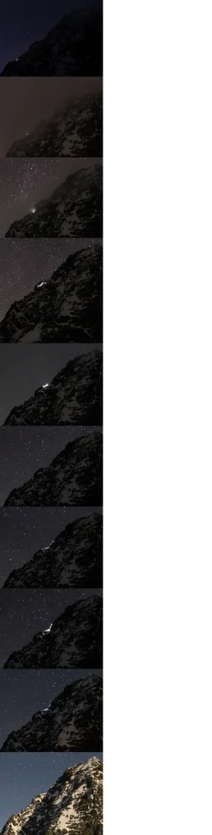
FOUND the web cam!!!! Adlersruhe / Blick nach Westen zum Großglockner - Foto-Webcam.eu
You can go back to Jan 18, and find the headlamps. Not video but still images taken every 10 minutes.
Here are 2 headlamps, at View attachment 630960View attachment 630959

Definitely the rescue police is telling the truth. Around 10:30 they illuminated the whole mountain trying to locate the pair. They said that no distress signals came. And, they say that even at that time, the flight was dangerous (you can see the wind at that time).

Also: one of the YouTube movies mentions that on that mountain, there is cell signal everywhere but specifically since the couple was Austrian is is doubly true. Austrian telephone system has very good coverage in Austrian Alps.

I trust them too as I was in Salzburg in the spring of 2024 and I might have even called someone from the castle on the mountain and the coverage even for US networks was great. It was high (Hohensalzburg fortress sitting atop a mountain of 506 m and I had to call home) so - not on top of Glockner mountain but close to it. I bet that alpine rescue police is not bending the truth.

So the public service did everything they could trying to help Kerstin.
 
Last edited:
  • #216
where did you read that?

The article in Explorersweb that I linked earlier says exactly this:

“At about 8:15 pm, they were still ascending. Witnesses saw headlamps on the upper section of the mountain. Other mountaineers had already abandoned their climbs because of harsh winds. Worried for the climbers, witnesses called the Alpine Police.

The police then identified the two climbers by examining the car parked in Kals. The police called the couple’s phones, but calls went unanswered.”

Also, the same article posted on January 26 2025 says: “ Over the last week, some climbers reported aborting ascents in the Alps because of strong winds.” So it probably happened on several days in a row.

Linking once again

 
  • #217
The article in Explorersweb that I linked earlier says exactly this:

“At about 8:15 pm, they were still ascending. Witnesses saw headlamps on the upper section of the mountain. Other mountaineers had already abandoned their climbs because of harsh winds. Worried for the climbers, witnesses called the Alpine Police.

The police then identified the two climbers by examining the car parked in Kals. The police called the couple’s phones, but calls went unanswered.”

Also, the same article posted on January 26 2025 says: “ Over the last week, some climbers reported aborting ascents in the Alps because of strong winds.” So it probably happened on several days in a row.

Linking once again


thank you I had just seen it in a video but I'm glad to have this article to read as well

there's pictures of his headlamp on his descent, as well as the rescuers with her bodybag 😢
 
  • #218
thank you I had just seen it in a video but I'm glad to have this article to read as well

there's pictures of his headlamp on his descent, as well as the rescuers with her bodybag 😢

I feel immensely sorry for the rescuers. They all did their best. The helicopter that landed as high as it could. The six people who had to lower her body down by 600 meters. In this video, the alpine guide, Peter S, at 6:45 min, says that the chance of her surviving had Thomas stayed with her would have been way higher. He is even showing how to keep a person warm in the mountains. You can see that this guide is mourning. So is the rescuer that was interviewed.


(You can switch auto-captions into English there. It is a short but good video).
 
Last edited:
  • #219
Third map - from Studlhutte to Frühstücksplatz (the breakfast spot)

View attachment 630770

So etiher start at 6:45 AM at Kals and have estimated time at Luckner 9:45 to get near Studl at 11:00 AM and standing in front of that wall that has Frühstücksplatz sign on it sometime around 1:00 PM
OR
Start at Luckner parking lot at 6:45 AM, get near Studl sometime around 8:45 AM and at Frühstücksplatz around 10:45 AM

Route there looks like:

View attachment 630771
View attachment 630772

View FROM the Grossglockner:

View attachment 630773

And thats where the yellow sign is:

View attachment 630774

So if they started at Luckner - theyre almost three hours behind the "estimated" time at "moderate" pace.
But if their starting point was in Kals, then theyre perfectly "in time" with these estimations considering that they took a break and actually ate some breakfast.

Which one is it?
Which one makes more sense?
Three hours behind makes sense considering their incredibly slow progress through the hardest, purely climbing part.
Next to no time "behind" also makes sense, cause that "incredibly slow" sounds like exactly how long would it take to have some totally rough climb in freezing cold, on icy stone, drowning in snow and likely needing breaks often but not in a form of sitting and chilling but somehow moving even a bit, to not get even colder.

To have Thomas's and his lawyer's tales of "bad luck" apply it would HAVE to be reasonable to expect that they can make it. Not only to the summit before sundown at 5:00 PM, but at least all the climbing down part through normal route on the way to Erzherzog-Johann hut.

But obviously, neither of these makes even the slightest sense in context of pushing past Frühstücksplatz.
Cause there was and isnt, absolutely no way that anyone in half-right mind could expect to make it to the summit and down to Erzherzog-Johann hut before sundown.
Worsening weather at night was totally foreseen and expected, it was just the matter of when exactly its gonna turn totally horrible, but it WAS OBVIOUS that it IS gonna get VERY COLD and VERY WINDY.

If its correct that they were at Frühstücksplatz at 1:30 PM then they have only 3,5 hours. Huge stretch on the limits of human body.
Possibly Thomas and few mountain goats could pull off that escapade in time but he wasnt accompanied by a wild goat who spend all her life in da mountains so that estimation couldnt be made. Not in good faith. No way. 0% chances. Not one in a mil, not one in a bil. Zero.

Unless Idk, maybe if they started at Luckner at 6:45 AM and get near Studl sometime around 8:45 AM and were at Frühstücksplatz sometime around 11:00 AM.
But E V E N T H E N it would leave them with 6 hours before sundown.

So like the narrowest of the narrow. Smoothest possible climb up and smoothest possible descend. At more than moderate pace it would likely still be just fast enough to pass the stony part of descend, not even get to the Hut.

Its not how summit fever works. It gets people as they have done all these preparations to go, spend all that money, made all that effort and/or went through so much to get so close to the summit...
They just went through few hours of hard, challenging HIKING trail on the way up the mountain they both lived relatively close to, and where Thomas climbed repeatedly.
And what then? Yup, were goin? Keep carrying that splitboard that you wont have a chance to use cause its gonna be totally dark if we even make it there?
Weather archive says that wind increased sometime around 10:00 AM. He was expecting it to suddenly get much better later in the day and higher up the mountain? Sure. I buy that. And I also wanna buy a Golden Gate Bridge.

View attachment 630775

And that "point B" on the third map is when the stone climb starts.
"Breakfast spot" and yellow sign is higher up.
Thats why my parking at Kals scenario indicated that their speed was incredibly good.
3 hours to Luckner + 2 hours to Studl + 2 hours to the climbing part of the route + some time to climb to Frühstücksplatz...

7,67km with 800m elevation (Kals-Luckner) with est. 3h
+ 2,84km with 560m elevation (Luckner-Studl) with est. 2h
+ 2,33km with 510m elevation (Studl-the wall) with est. 2h
+ ~250m with 283m elevation (from 3.297m to 3.580m / the wall-the spot)

13,09km with 2153 elevation in ~6,5 hours aint no "slow speed" thats incredibly fast.

Removing the part 1 (Kals-Luckner) with est. 3h, 7,67 km and 800m elevation its STIILL no slow speed.
5,17km with 1070 elevation (Luckner-the wall) with est. 4 hours
+ ~250m with 283m elevation (from 3.297m to 3.580m / the wall-the spot)
in winter, in snow.
That implies some 1-1,5 hour delay in comparison to estimated three hours time on the way from Studl to Fruh thats mentioned on the yellow sign but still, in Winter... I still cant consider it as incredibly slow in context of making that distance.
Its dangerously, scarily slow in context of climbing up to the summit so it absolutely should NOT WORK in favors of Thomas's alleged theoretical, optimistic, good willed, summit feverish decisions repeatedly made as they got to the climbing part of the Grossglockner and as they were passing the yellow sign.

Their car was parked in Kals, and the article says that this is where they started.
 

Guardians Monthly Goal

Staff online

Members online

Online statistics

Members online
74
Guests online
1,415
Total visitors
1,489

Forum statistics

Threads
635,984
Messages
18,687,988
Members
243,479
Latest member
McVille21
Back
Top