Hatfield
Well-Known Member
- Joined
- May 3, 2012
- Messages
- 17,014
- Reaction score
- 157,643
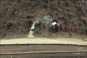
The road where the skull was found is at that tower, right? A little further west from where the blue line ends on the map a WSer posted. To me the entrance to that tower area just off the main road is what looks the most like the aerial view of the news crew.
Yes, I think you are correct.
I brought up County Corner Road on Google Earth, and I think there is a Cell Phone Tower on a dirt road that looks just like the dirt road that the 2 grey cars were parked on that had that fenced in area just beyond it.
I wonder if the fenced in area is protecting the Cell Phone tower and its equipment.
If that is it, I didnt see where that road continued any further back but I suppose there maybe many smaller trails that would not show on Google Earth from that point further back into the woods. The 1 article said 300 yards or so back so I suppose there are trails and 4 wheel drive paths that go further back in those woods.
I also noticed some sort of mining or gravel type pits further to the East back towards Bible Hill Road.
I wish I could post snapshots of what I am seeing on Google Earth but I havent figured out how to get them to WS. If I had more time, I would try to post them here.
Its easy to spot on Google Earth though. I just put in search for this:
County Corner Rd, Holladay, TN 38341, USA
and it brought me to that dirt road that had the Cell Phone tower on it. The Google Earth image had the tower messed up and laying sideways but that sometimes happens as Google maps out the earth views + overhead shots, it sometimes messes up things like that.