- Joined
- May 15, 2013
- Messages
- 55,635
- Reaction score
- 315,026
Several tropical waves exist with the potential to develop tropical maturity over the next five days including a new system that spawned Monday night near the Cabo Verde Islands.
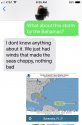
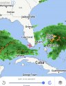
The system closest to Florida is producing disorganized showers and thunderstorms near Hispaniola. It’s expected to move over the Bahamas and Florida between Thursday and the weekend. The storm has a 50 percent chance of tropical development within that time, and 10 percent chance of forming in the next 48 hours.
However, NHC meteorologists are expecting little from the storm due to environmental conditions being unfavorable.
It will produce rain across a wide swath of Florida regardless of tropical formation. The current NWS forecast has Lakeland experiencing rain Friday straight through Monday night, each day ranging in the 60% to 70% range with thunderstorms possible.
Just west of the storm, the second disturbance lying in the mid-Atlantic has a 20 percent chance of becoming a tropical depression in the next 2 to 5 days. The system, currently near the Lesser Antilles, is expected to encounter upper-level winds diminishing its chances of organizing itself into a tropical depression.
The third tropical wave, which developed Monday evening near the Cabo Verde Islands, has a 20 percent chance of becoming a tropical depression in the next five days as it heads toward the Lesser Antilles.
If any of the systems should organize into a tropical depression it will be the ninth recorded depression of the year. If it then grows to maintain at least 39 mph sustained winds, it would become Tropical Storm Humberto.
Humberto remains possible to form as system targets Florida