Found Deceased Jenny Hall, 23, described as a keen long distance runner, vehicle located on the B2678 between Eggleston & Stanhope, County Durham, Feb 18 2025.

  • #141
parking there to jog in Hamsterley forest is like catching a train to Bradford when you want to go shopping in Leeds!

it makes no sense whatsoever - Hamsterley forest has plenty of proper parking areas for walkers and runners
 
  • #142
parking there to jog in Hamsterley forest is like catching a train to Bradford when you want to go shopping in Leeds!

it makes no sense whatsoever - Hamsterley forest has plenty of proper parking areas for walkers and runners
I thought that too. Unless the Police have information that she regularly did this run.

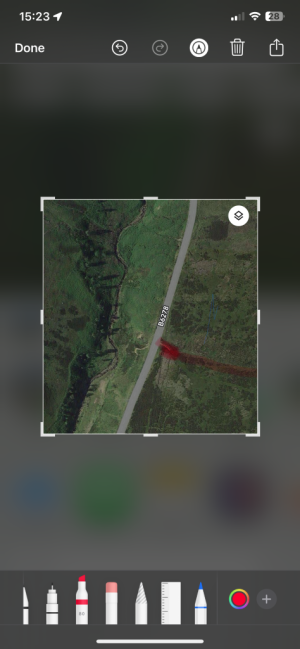
This is a closer-up/zoomed in arial map. Red arrow is approximately where the layby is. You can see there are no trails on the moor (brown blotchy area to the right of the road). And the dark green area beyond it on the right, with trails showing, is Hamsterley forest.

But either she knew that moor very well, or it was not a place to go running, with peat bogs and rickety mine shaft openings.

Moor.jpg
 
  • #143
Someone earlier suggested they had a feeling she may have gone to the area on the left rather than across the moor to the forest (which seems to be a guess or assumption by the police - they said the forest was one of her usual runs). I also thought she may have gone left and there is a brook at the bottom on the left. But assume they have searched that area as well.
 
  • #144
The nearest walking path is about a mile further along the road - so she could have run along the road to that, but it seems unlikely if she is described as a "fell runner" in places.
 
  • #145
I just have this awful feeling they are not going to find her.
 
  • #146
  • #147
The nearest walking path is about a mile further along the road - so she could have run along the road to that, but it seems unlikely if she is described as a "fell runner" in places.
In fact, Google sat view actually does show a track that starts just to the south of the lay-by and which enters into the moor to the right (east) and then loops north to the walking path you refer to. That leaves a final stretch back down the main road to the car to complete a loop.
 
  • #148
the police have been stung by the Nicola Bulley case and now find themselves not able to share even the smallest details about this girl

they are clearly focusing the search in a fixed area which suggests that they must think it's a non-moving person they are seeking.

sadly i feel this doesn't end well but also i can't help thinking that once again the secrecy used by the police is only serving to whip-up speculation and does nothing to help locate her
 
  • #149
This is the live updates on a regional newspaper page. It just says the search is continuing on the fifth day (today). Further down it does say they have searched the wider Teesdale area.

 
  • #150
the police have been stung by the Nicola Bulley case and now find themselves not able to share even the smallest details about this girl

they are clearly focusing the search in a fixed area which suggests that they must think it's a non-moving person they are seeking.

sadly i feel this doesn't end well but also i can't help thinking that once again the secrecy used by the police is only serving to whip-up speculation and does nothing to help locate her
Agree. I think it would be helpful if they would ask everyone who drove on that road that day to come forward to see if they saw anything. Maybe they have but it hasn't been publicised. It's not a busy road - but there is regularly traffic along it every day.
 
  • #151
In fact, Google sat view actually does show a track that starts just to the south of the lay-by and which enters into the moor to the right (east) and then loops north to the walking path you refer to. That leaves a final stretch back down the main road to the car to complete a loop.
Do you mean this one? That's a long way south of the layby. Maybe a couple of miles south. Police have already been round farms in that area, searching barns etc. There isn't anything north of that until the main track a mile further along from the layby. (Just informed by someone who knows the moor well).
Track.jpg
 
  • #152
Just been reading up on this case.

I think it’s clear the police have additional information imo which probably points towards mental health struggles.

Unfortunately, I think everything is pointing towards a suicide.

I hope she’s found soon.
 
  • #153
Do you mean this one? That's a long way south of the layby. Maybe a couple of miles south. Police have already been round farms in that area, searching barns etc. There isn't anything north of that until the main track a mile further along from the layby. (Just informed by someone who knows the moor well).
View attachment 565899
 
  • #154
The track that starts here, faint but obvious when you zoom in.
 

Attachments

  • IMG_1595.png
    IMG_1595.png
    363.8 KB · Views: 43
  • #155
There was a similar case locally last year. Young person left home with walking gear, took a train to a remote station on the moors and disappeared. She was sadly found 3 months later.
I hope they find Jenny quickly. Moors and woodland are very difficult areas to search.
 
  • #156
  • #157
Just been reading up on this case.

I think it’s clear the police have additional information imo which probably points towards mental health struggles.

Unfortunately, I think everything is pointing towards a suicide.

I hope she’s found soon.
Exactly. I think it's very much like the Huszti sisters case, where the police pretty much know from the start what has happened and there's not much need for the public's involvement.
 
  • #158
The track that starts here, faint but obvious when you zoom in.
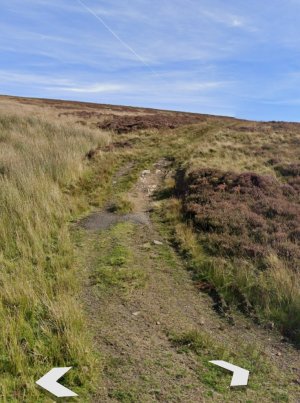
If there's a line, it's probably dips and gulleys like this. It's just open moorland, no trails or tracks.

Gulley.jpg
 
  • #159

Attachments

  • IMG_1596.jpeg
    IMG_1596.jpeg
    315.3 KB · Views: 49
  • #160
This is the tool I used to get an idea of unofficial passable tracks in the area. Sadly, I can't find a way to drop a pin to take you to the correct part of the map but typing Hamsterley Forest in the search bar takes you close enough to zoom in and look. CycleStreets: UK-wide Cycle Journey Planner and Photomap: Cycle journey planner

(I recommend this site/app even if you're not a cyclist or hiker. It shows loads of 'local knowledge' pedestrian cut-throughs in urban areas that can be super useful)
 

Staff online

Members online

Online statistics

Members online
123
Guests online
3,008
Total visitors
3,131

Forum statistics

Threads
632,113
Messages
18,622,209
Members
243,023
Latest member
roxxbott579
Back
Top