Found Deceased Spain - Esther Dingley, from UK, missing in the Pyrenees, November 2020 #6

Status
Not open for further replies.
  • #601
I don't think he could reach her, bringing this post forward.
That's the best scenario imo. Then there can be no accusations of contaminating the scene and forensics can do their job - hopefully putting an end to continuing speculation on the net.
 
  • #602
IMO Chris Brockman did what others should have done before they published messages about the yellow tent allegedly missing: he checked with the authorities and used a general term, that would have included the tent.

The authorities will await confirmation. My bet is that, if the backpack was found in good order, the tent and the other camping gear will be in it too.

Yeah good point. In fact it seems to me on rereading it that he's just saying no confirmation received about gear generally (as you say) rather than speculate. Nice to see sensible journalism among all the other stuff.
 
Last edited:
  • #603
This is the same view from higher up the Pic de Sacroux. The lower ridge of the Sacroux obscures the screes below the Pic de la Glère, but there's a good view of the whole border ridge to the pyramidal summit of the Pic de Sauvegarde and beyond:

http://ekladata.com/bEqbK2kGzOoy76F-GpQ4RBmJ8ig.jpg

In the midground, at the end of the spur to left of the Pic de la Montagnette, you can clearly make out the famous "shortcut" that runs down the prominent gully and into the cirque below.

Thanks for that. You can see a few places where a body could fall and be hidden from many angles.
 
  • #604
This is the same view from higher up the Pic de Sacroux. The lower ridge of the Sacroux obscures the screes below the Pic de la Glère, but there's a good view of the whole border ridge to the pyramidal summit of the Pic de Sauvegarde and beyond:

http://ekladata.com/bEqbK2kGzOoy76F-GpQ4RBmJ8ig.jpg

In the midground, at the end of the spur to left of the Pic de la Montagnette, you can clearly make out the famous "shortcut" that runs down the prominent gully and into the cirque below.

So basically that's the view eastwards along the so-called ridge route from Sauvegarde is it? There looks to be a bit of a path on the right of the picture.

I know it's only about 2km, but I'm finding it hard to imagine she made it along that route from Sauvegarde and to the top of Pic de la Glere on 22nd. It looks like there'd be a lot of ups and downs, unless that path on the right weaves between the higher points ans stays more level?
 
Last edited:
  • #605
Thanks for that. You can see a few places where a body could fall and be hidden from many angles.

Also, she was wearing a dark coloured jacket and her rucksack is, I think, grey. Neither of which would be highly visible against a mountain backdrop.
 
  • #606
This is the same view from higher up the Pic de Sacroux. The lower ridge of the Sacroux obscures the screes below the Pic de la Glère, but there's a good view of the whole border ridge to the pyramidal summit of the Pic de Sauvegarde and beyond:

http://ekladata.com/bEqbK2kGzOoy76F-GpQ4RBmJ8ig.jpg

In the midground, at the end of the spur to left of the Pic de la Montagnette, you can clearly make out the famous "shortcut" that runs down the prominent gully and into the cirque below.
Pic de la Glere looks quite unhikable in that picture, and as there is no known path going up there, and I can't find any record of anyone having gone up it, I can't believe Esther would even consider it.

If she wanted to get higher, she would surely take the proper path on the opposite side of the col going up Sacroux. That path though doesn't skirt anywhere near the sheer edge of the mountain and doesn't meet a precipice (as far as I can tell) until the very top - and I don't think it is suggested she fell off the top of Sacroux...

All I can surmise is that she scrambled up the ridge a short way east of the Port (along the lower shoulder of Pic de la Glere) and fell from there.
 
  • #607
It's bizarre (though I suppose we knew it would be). Having scoured Google Earth, the only places where she could have fallen to her death without being easily spotted are well off the path and hardly places she (or anyone) would want to get to, especially in that season. It's surely technically possible to get up to the ridge to the east of P de la Glere, or even to the top of that small pic, but it would be quite a scramble and the view from the top would hardly be worth it (not much better than from P de la Glere itself and nothing like as good as from Sauvegarde).

I'm assuming she was found on the French side, though as usual it's the drip-drip of information that is liable to get distorted along the way. They could easily describe exactly where she was found or even pin-point it on a map, but it's always a case of 'betray the information, lose the power'. As was definitely the case with Libby Squire in Hull, the authorities are desperate not to let the public crack the case before they do. It's possible we may never get to know the exact spot where Esther fell/was found.

In the meantime, given the oddness of the likely location, suicide still has to be a possibility.

Red Arrow = estimated location of body
Yellow Arrow = estimated location of partial skull

We have been looking at this area since the skull was found, wondering whether she was ascending or descending this area. It's possible that she arrived at the port and started to descend the trail. We have read that the area is slippery in November (keeper at Refuge de Venasque). Perhaps the shale was moving under her feet. The area near the Port looks particularly steep to me. Perhaps she was quickly in a situation where she could not climb back up, and going down was too dangerous. She might look for larger rocks to get better traction. With her heavy pack, the wind, shale and Winter moisture, it seems quite possible that she start the trail and was instantly in trouble with no way to move up or down.

upload_2021-8-11_9-41-48.png
 
  • #608
That's why I'm leaning toward her going to Pic de Sacroux. It's got a great viewing area and there seems to be a short path up to there from Port de la Glere.

I'm wondering that too. That is listed as a difficult climb. That would place her body somewhere in the yellow circle. Red arrow is estimated location of skull.

upload_2021-8-11_9-59-22.png
 
  • #609
I'm wondering that too. That is listed as a difficult climb. That would place her body somewhere in the yellow circle. Red arrow is estimated location of skull.

View attachment 308399

It sounded to me more like they found her on Pic de la Glère, although the language is imprecise:

“A source close to the paper said that the remains were found in a “very rugged area” around the Pic de la Gléré, a remote peak that is difficult to access. After discovering her body, Mr Colegate then called the police who came to the scene. “

Body of missing British hiker Esther Dingley discovered by boyfriend
 
  • #610
Red Arrow = estimated location of body
Yellow Arrow = estimated location of partial skull

We have been looking at this area since the skull was found, wondering whether she was ascending or descending this area. It's possible that she arrived at the port and started to descend the trail. We have read that the area is slippery in November (keeper at Refuge de Venasque). Perhaps the shale was moving under her feet. The area near the Port looks particularly steep to me. Perhaps she was quickly in a situation where she could not climb back up, and going down was too dangerous. She might look for larger rocks to get better traction. With her heavy pack, the wind, shale and Winter moisture, it seems quite possible that she start the trail and was instantly in trouble with no way to move up or down.

View attachment 308398

So, adding to your picture (a bit roughly drawn by me) I've included possible routes via the ridge route (green) or via the anti-clockwise loop (red), does that seem plausible?
 

Attachments

  • Picdelaglere2.jpg
    Picdelaglere2.jpg
    399 KB · Views: 97
  • #611
I've annotated a couple of maps to aid further discussion. The yellow star is an approximate location of where the fragment of her skull was found. We know it was spotted from the path, at approximately 2200m.

We now know that ED's body was found 'in a very rugged area' below Pic de la Glere, and that it was 'in a natural hideaway, such as a gully'. I've marked the most likely area with a yellow box.

(Edited to change file format from pdf to jpg)
 

Attachments

  • ED Map 1 (Wide Angle).jpg
    ED Map 1 (Wide Angle).jpg
    116.4 KB · Views: 121
  • ED Map 2 (Zoom).jpg
    ED Map 2 (Zoom).jpg
    111.9 KB · Views: 116
  • #612
I guess if she has ended up somewhere that’s it’s impossible to get to on purpose, it means she can only have fallen there from above. So if she was found on a ledge below a cliff, and couldn’t have climbed onto it herself, she can only have dropped there from above. This might be why the police seem certain it was an accident.

I’m also wondering now, whether Dan found her remains by sight (binoculars/drone?) rather than actually being able to physically reach her.

Not sure I’ve explained that very well, hope it makes sense!

Yes, makes sense to me.

This is from the BBC report.

“A spokesman for the overseas crisis support charity said Mr Colegate found his girlfriend's remains on Monday afternoon, close to where the bone fragment was discovered.

Chris Bockman, a British journalist working in Toulouse, said French police searches had been hampered by a number of search and rescue operations and thunderstorms.

He said according to the French judge leading the investigation, officers are beginning to collect forensic information at the "difficult to reach site" which will be DNA analysed, while a helicopter will be used "if necessary" to recover Ms Dingley's body.”
 
  • #613
  • #614
Red Arrow = estimated location of body
Yellow Arrow = estimated location of partial skull

We have been looking at this area since the skull was found, wondering whether she was ascending or descending this area. It's possible that she arrived at the port and started to descend the trail. We have read that the area is slippery in November (keeper at Refuge de Venasque). Perhaps the shale was moving under her feet. The area near the Port looks particularly steep to me. Perhaps she was quickly in a situation where she could not climb back up, and going down was too dangerous. She might look for larger rocks to get better traction. With her heavy pack, the wind, shale and Winter moisture, it seems quite possible that she start the trail and was instantly in trouble with no way to move up or down.

View attachment 308398

What your photo helps make clear is how a fall in that terrain could readily be catastrophic or fatal.
 
  • #615
Pic de la Glere looks quite unhikable in that picture, and as there is no known path going up there, and I can't find any record of anyone having gone up it, I can't believe Esther would even consider it.
I've found a couple of ascents online. The ascent from the French side mentioned above in the thread talks about "quelques cairns qui le mèneront jusqu'à une selle herbeuse, ce qui semble être la voie "normale" d'ascension" (some cairns that lead to a grassy saddle, which seems to be the "normal" route of ascent):

http://robertetlespyrenees.kazeo.com/pic-de-sacroux-2676-m-et-pic-de-la-glere-2496-m-a120142244

This Spanish site describes a scramble from the southeastern slope, behind the Turonet de Gorgutes:

Montesymasdebucuesa: 42-14. PICO DE LA GLERA POR LA ARISTA SUDOESTE. 6-6-14.

There may be other routes.

All I can surmise is that she scrambled up the ridge a short way east of the Port (along the lower shoulder of Pic de la Glere) and fell from there.
That seems possible to me, but I think she would have had to ascend the ridge a fair way.
 
Last edited:
  • #616
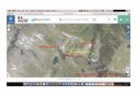
They actually came up the very rugged French side, where Esther likely fell. The couloirs are the two steep gullies above the scree slope. Esther's more likely to have come to the summit from the gentler Spanish side, I would guess.

This is the Pic de la Glère from the slopes of the Pic de Sacroux looking towards the Pic de Sauvegarde in the distance. France on the left, Spain on the right:

http://ekladata.com/WWb9HwNw8jBiIpJ8GV5FDG2vOvw.jpg
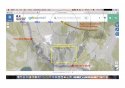

The Port is quite enclosed, and the Spanish side is fairly flat initially around the Ibon de Gorgutes lake. The Pic would give a better view of the trail in both directions, and it's quite plausible to me that she would scramble up for a better view of the route she'd just followed.

What a terrible shame.

Strongly agree, from what Dan has written, and their blog, I can't see ED risking the steep scree slopes from the French side, that looks crazy. She had probably just cleared the Port and thought that the mini Pic de la Glere didn't look at all difficult from the Spanish side. It was at the end of her hiking holiday and the Pic could have seemed one last good chance to viewing point and photograph, looking at the Pyrenees of France and Spain. It was also one last mountain peak, before setting off down and for home.

As a last minute decision, she probably didn't (or couldn't) check it out and trusted just to what she could see. She may just have got too close to the crumbly edge at the top, which could also have had snow patches.

The reason nobody had heard from her for a while was probably just because her phone was out of, or very low, on power so being saved for emergency.
 
  • #617
So basically that's the view eastwards along the so-called ridge route from Sauvegarde is it?
Right.

Grouse said:
There looks to be a bit of a path on the right of the picture.
I think those are eroded rock fissures. The tilted layers of harder and softer rocks erode at different rates, giving the appearance of a trail along the ridge.

Grouse said:
I know it's only about 2km, but I'm finding it hard to imagine she made it along that route from Sauvegarde and to the top of Pic de la Glere on 22nd. It looks like there'd be a lot of ups and downs, unless that path on the right weaves between the higher points and stays more level?
I agree. I've seen nothing to suggest that there's a walkable route along the ridge.
 
  • #618
So, adding to your picture (a bit roughly drawn by me) I've included possible routes via the ridge route (green) or via the anti-clockwise loop (red), does that seem plausible?

I'm increasingly convinced that she approached the Port de la Glere from Spain, and that the Refuge de Venasque was the destination. The ridge route is consistent with perhaps a lofty goal of hiking the ridge - marking a new path.

Perhaps the two hikes to the Pic de Sauvegarde summit were to scope out a possible route to Port de la Glere that did not involve the trails to the parking lot at Hospital de Benasque. Perhaps she did bivouac somewhere on the Spanish side of the mountains on Nov 22.

The alternative is that she approached the Port de la Glere from France, saw the scree, realized the dangerous hike, and still attempted it. That doesn't seem like a decision of an experienced hiker. She should have known when to turn back.
 
  • #619
I've annotated a couple of maps to aid further discussion. The yellow star is an approximate location of where the fragment of her skull was found. We know it was spotted from the path, at approximately 2200m.

We now know that ED's body was found 'in a very rugged area' below Pic de la Glere, and that it was 'in a natural hideaway, such as a gully'. I've marked the most likely area with a yellow box.

(Edited to change file format from pdf to jpg)

Somewhere in this area, I suppose. The Port de la Glere trail on the left.

upload_2021-8-11_11-49-10.png


Géoportail
 
  • #620
I'm wondering that too. That is listed as a difficult climb. That would place her body somewhere in the yellow circle. Red arrow is estimated location of skull.

View attachment 308399

This is not the correct area as it is described as below the pic de la glere and above the porte.
 
Status
Not open for further replies.

Staff online

Members online

Online statistics

Members online
86
Guests online
1,370
Total visitors
1,456

Forum statistics

Threads
632,379
Messages
18,625,445
Members
243,119
Latest member
GermanFFreddy
Back
Top