WA WA - D.B. Cooper hijacking mystery, 24 Nov 1971 - #3

Status
Not open for further replies.
  • #321
BTG
BATTLE GROUND VORTAC
BATTLE GROUND, WA

Location

Lat/Long: 45-44-52.120N / 122-35-29.532W (45.7478111/-122.5915367)
Elevation: 253.0 ft.
Variation: 21E (1975)
Operational Characteristics

Type: VORTAC
Class: H-VORTACW
Frequency: 116.60
TACAN channel: 113X
Altitude code: H (high)
Hours of operation: 24
Voice ID: no
Morse ID: -... - --.
NOTAM facility: PDX
FSS:
FSS hours of operation: 24
 
  • #322
DB Cooper is an interesting case. First heard of it from a TV show.
 
  • #323
what was the date on the NY times? there are a lot of Thomas Manning's in the SSDI, a year would help pin point the time of death.

AP, Published: November 12, 1987

Said he "died Tuesday."

Searching for him was intriguing because of who else comes up. There is apparently a singer, a prisonmate who is apparently a cult hero, and a criminologist who did a paper on child abuse. I'm not sure he was "Thomas." Everything calls him "Tom."

BTW: I do have a '68 pic of Milnes before he was head FBI, NW region.
 
  • #324
BTG
BATTLE GROUND VORTAC
BATTLE GROUND, WA

That's the one. It was identified as "Portland" at hijack time. It is possible that the crew thought they passed east of PDX because they passed east of this VORTAC. They weren't accustomed to the low-level flying. VORTACs were usually named for an airport where they were located. This was out of the norm in that respect. No doubt the reason its name was changed.
 
  • #325
DB Cooper is an interesting case. First heard of it from a TV show.

'Tis indeed. I'm sure it would be fascinating even if it had not become overwhelmed by misinformation almost from the start.
 
  • #326
The middle one could be Milnes. Roughly the same build. If Manning was built as you said, it could be him too. I've searched some and not found any pic from other stories. NY Times had his obit, which didn't even say where he died. Maybe something will float by some day.

Let me ask straight out - how important is this? You can email me.
I do have resources I could tap IF this is important ? Your call..
 
  • #327
  • #328
The thing you're referring to is not a concrete pad. It is a navigation aid that sits on a concrete pad. It's called a VORTAC. It's like a radio beacon. Shaped like a big hat with a dunce cap on top. The area where DB is thought to have jumped is only a few miles from what was then called the Portland VOR a little SW of Battle Ground, WA (near Vancouver and Portland). There is even some possibility that he was vitually there when he jumped. The low-level planes would fly toward it from a turn up north, then turn near it to go the remaining short distance to Portland International Airport. I'm sure Mr..45 is working on going nearly right over it because pilots follow it rather than watching scenery to tell where they are.

It wasn't really "wilderness." More like "in the countryside." Farm roads all around.

The fact that the thing marked a turning point could help someone sense being there even if the person was blind, so it could have been a good spot for DB to pick.

Here's a VORTAC, what one looks like, near me.
 

Attachments

  • VORTAC.jpg
    VORTAC.jpg
    52.6 KB · Views: 14
  • #329
Let me ask straight out - how important is this? You can email me.
I do have resources I could tap IF this is important ? Your call..

I can't imagine any real value in it Georger. I think work on the oscillations, pressure bump and jump time is way more important. Thanks.
 
  • #330
BTG
BATTLE GROUND VORTAC
BATTLE GROUND, WA

Location

Lat/Long: 45-44-52.120N / 122-35-29.532W (45.7478111/-122.5915367)
Elevation: 253.0 ft.
Variation: 21E (1975)
Operational Characteristics

Type: VORTAC
Class: H-VORTACW
Frequency: 116.60
TACAN channel: 113X
Altitude code: H (high)
Hours of operation: 24
Voice ID: no
Morse ID: -... - --.
NOTAM facility: PDX
FSS:
FSS hours of operation: 24


Maylay vortac courtesy of Farflung:
see: http://www.dropzone.com/cgi-bin/for...arch_string=PDX Vortac;guest=89423311#4279049

attached . . .

Maylay intersection.
Flight Path maps.

Let me attach some FP maps for reference here. I have a many-many maps for this case so ask if you need something -
 

Attachments

  • FBI Mystery Chart.jpg (225 KB).jpg
    FBI Mystery Chart.jpg (225 KB).jpg
    126.2 KB · Views: 7
  • Maylay intersection-.jpg
    Maylay intersection-.jpg
    80.8 KB · Views: 6
  • FBI FP map.jpg
    FBI FP map.jpg
    97.6 KB · Views: 9
  • #331
I can't imagine any real value in it Georger. I think work on the oscillations, pressure bump and jump time is way more important. Thanks.
ok - ...........................
 
  • #332
Malay is only an intersection. No navigation aid located there. But it is where the turn up north would normally occur.
 
  • #333
attached . . .

Maylay intersection.
Flight Path maps.

Let me attach some FP maps for reference here. I have a many-many maps for this case so ask if you need something -

Glad to see you posted the actual map from the FBI.
 
  • #334
Malay is only an intersection. No navigation aid located there. But it is where the turn up north would normally occur.


I made changes - for some reason cant get a large version of the FBi map to post. will work on it...

Here hopfully is the FBI version flight path map. Nope, nothing Im uploading is working reight, only small versions. Been that kind of day!
 

Attachments

  • @1971 FBI Flight AAAsml ZZZ to share - .jpg
    @1971 FBI Flight AAAsml ZZZ to share - .jpg
    85.5 KB · Views: 15
  • #335
I have been doing practice runs on the simulator, as for the flaps, is it 15 degrees as said on the transcripts, or is it 30 degrees as mentioned on Citizen Sleuths?

also seems to be a point where they were at 15,000 ?

I have made several runs to Toledo as for my first leg, if I go at a airspeed of 200, I arrive to early, if I travel at around 165 to 180, I arrive in 23/24 minutes?

once I get the path from Sea Tac to Merwin lake area down pat, I have several different flight patterns to try.

I think my first several flights were too fast and this is why it was putting me in upper Vancouver? I kept the airspeed at 200 all the way. (I need a copilot) :floorlaugh:

I mark my time at 7:36 and 30 seconds, transcript shows them calling out 1000 feet at 7:37, I arrive at the altitude leaving at that given time.

I now have most of the bugs out of the system and can add passengers seat by seat as well as crew cargo & passenger cargo.

I can "turn key" start the plane, or cold dark start.
 
  • #336
I have been doing practice runs on the simulator, as for the flaps, is it 15 degrees as said on the transcripts, or is it 30 degrees as mentioned on Citizen Sleuths?

I believe they went to 30d right before the oscllations/bump.
Snow even used this point to test people at DZ... you can try both?
 
  • #337
I have been doing practice runs on the simulator, as for the flaps, is it 15 degrees as said on the transcripts, or is it 30 degrees as mentioned on Citizen Sleuths?

I believe they went to 30d right before the oscllations/bump.
Snow even used this point to test people at DZ... you can try both?

Yep, I can do both, will try, thanks :rocker:
 
  • #338
I have been doing practice runs on the simulator, as for the flaps, is it 15 degrees as said on the transcripts, or is it 30 degrees as mentioned on Citizen Sleuths?

They took off and climbed to 7000' with 15°. When they leveled off at 7K' (at 7:40:37) they changed to 30°. Said they intended to be about 160KIAS.

At 7:42 they were 14nm out of SEATAC, at 7K', had 30° flaps, and were at "approach" speed. At 7:44:22 they reported the stair down. At 7:45 they were 19nm out of SEATAC and still at 7K'. At 7:48: 160KIAS, at 7K', GOING TO 15° AND STARTING THEIR CLIMB.

7:50:05 Toledo gave them altimeter setting 29.98" Hg.

7:51:31 "through 9K' now"

7:53:34 Leveling at 10K'

7:53:40 170 to 180 KIAS.

also seems to be a point where they were at 15,000 ?

They reported 15K' and immediately corrected. They were actually at 10K'.

I mark my time at 7:36 and 30 seconds, transcript shows them calling out 1000 feet at 7:37, I arrive at the altitude leaving at that given time.

I don't understand what you mean. The transcript has air traffic control verifying the flight is assigned 10K' at 7:37:17.

I can "turn key" start the plane, or cold dark start.

"Turnkey" for beginners. You're making great progress.
 
  • #339
They took off and climbed to 7000' with 15°. When they leveled off at 7K' (at 7:40:37) they changed to 30°. Said they intended to be about 160KIAS.

At 7:42 they were 14nm out of SEATAC, at 7K', had 30° flaps, and were at "approach" speed. At 7:44:22 they reported the stair down. At 7:45 they were 19nm out of SEATAC and still at 7K'. At 7:48: 160KIAS, at 7K', GOING TO 15° AND STARTING THEIR CLIMB.

7:50:05 Toledo gave them altimeter setting 29.98" Hg.

7:51:31 "through 9K' now"

7:53:34 Leveling at 10K'

7:53:40 170 to 180 KIAS.


They reported 15K' and immediately corrected. They were actually at 10K'.


I don't understand what you mean. The transcript has air traffic control verifying the flight is assigned 10K' at 7:37:17.


"Turnkey" for beginners. You're making great progress.

I am going by my time, sorry should have said that, Hominid said they took off at 36 minutes past the hour, I read the transcript again and see my mistake, I was thinking they said 1000 and not the assigned 10,000 :blushing:

nevertheless, I have been taking off at 7:36 and 30 seconds and arriving at Toledo via V 23 at 23/24 minutes after take off. airspeed about 160/170

I need to make a flight check list, just flying the plane in this configuration needs a constant visual out the window, the plane drags and wants to go down, if I divert attention away from flying, I am all over the place :floorlaugh:

I am completely amazed on how well this system is working speed, locations
GPS maps, even gives me a Vector to follow on my map, I have 95% control of all instrumentation on the plane, not to much is a "dummy switch" extremely realistic.

much like Cooper, I can not get the aft stairs down on the dreamfleet, I can lower them on the first part of the software, it tells you how to do it but, nothing happens, I'm wondering if it has something to do with my wireless keyboard, to lower the stairs you hit shift + E at the same time, then 2, might be to much on the board commands for wireless?

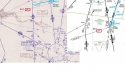
I will take a screen shot just over Merwin Lake, there is not a lot of room to go back and forth (east/west) from the view at 10,000.

I am slowly learning how to manually start and stop the engines, lots to learn on that which can be done later, well, off to fly another shift :rocker:
 
  • #340
Status
Not open for further replies.

Members online

Online statistics

Members online
71
Guests online
4,140
Total visitors
4,211

Forum statistics

Threads
632,649
Messages
18,629,694
Members
243,235
Latest member
MerrillAsh
Back
Top