
You are using an out of date browser. It may not display this or other websites correctly.
You should upgrade or use an alternative browser.
You should upgrade or use an alternative browser.
2024 Hurricane and Tropical Weather
- Thread starter PayrollNerd
- Start date


PayrollNerd
Well-Known Member
- Joined
- Feb 3, 2018
- Messages
- 18,663
- Reaction score
- 110,070
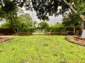
The lake in the back yard starts to recede in between bands of rain. The sun is out at times. My corn looks like it’s nearly flattened. It’s a raised bed with sweet potatoes too. It should drain but it will take time.
I forgot to bring my garden tools inside so they’re sitting in water. There’s a number of oak tree branches down. I have tree loppers to get them cut up.
I had to drive my daughter to do her necessary errands. Her car sits too low and so many streets were flooded. We had to turn around twice. But there were still people driving thru the water anyway! Once we got to 2 places, they were closed!
Attachments


GatorFL
Well-Known Member
- Joined
- Jan 1, 2009
- Messages
- 2,339
- Reaction score
- 15,920
Not too bad for as long as Debby hung around.The lake in the back yard starts to recede in between bands of rain. The sun is out at times. My corn looks like it’s nearly flattened. It’s a raised bed with sweet potatoes too. It should drain but it will take time.
I forgot to bring my garden tools inside so they’re sitting in water. There’s a number of oak tree branches down. I have tree loppers to get them cut up.
I had to drive my daughter to do her necessary errands. Her car sits too low and so many streets were flooded. We had to turn around twice. But there were still people driving thru the water anyway! Once we got to 2 places, they were closed!
Did you hear about the lady in Orlando who is in a fight with her HOA and so she concreted over the storm drain? Her whole neighborhood floods from a little rain, I bet those houses are flooded now.
HmmMysterious
Well-Known Member
- Joined
- Dec 30, 2021
- Messages
- 1,529
- Reaction score
- 7,865
Something pretty unique is going on in the Pacific. TS Emilia and Fabio are interacting with each other, a phenomenon that's called a Fujiwara effect. One of them will absorb the other at the end of this process. In this case, Emilia will absorb Fabio according to the NHC. Both of them won't threaten land.

PayrollNerd
Well-Known Member
- Joined
- Feb 3, 2018
- Messages
- 18,663
- Reaction score
- 110,070
The system is expected to move slowly through southeastern Georgia until its center emerges over the Atlantic on Tuesday.
PayrollNerd
Well-Known Member
- Joined
- Feb 3, 2018
- Messages
- 18,663
- Reaction score
- 110,070
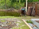
The back yard lake is draining. A muddy mucky mess. Still some random downpours from the tail. Looked at the breaks in my plumeria. They’re pretty severe. They root pretty well. Once it’s dry enough to work out there, I’ll get them trimmed and replanted. This time I’ll add more rebar and tie them off more.
Attachments


HmmMysterious
Well-Known Member
- Joined
- Dec 30, 2021
- Messages
- 1,529
- Reaction score
- 7,865
CSU revised the prediction slightly downward, now it's predicting 23 named storms which is still a lot. Some disturbing estimates in the 47 page 2024 predictions that it published. https://tropical.colostate.edu/Forecast/2024-08.pdfColorado State University is now calling for 25 named storms, 12 hurricanes, and 6 major hurricanes for this season. The Accumulated Cyclone Energy is predicted to be an extremely high 230.
CSU Hurricane Seasonal Forecasting
The CSU is predicting:
- The probability of at least ONE major hurricane to hit the entire U.S continental coastline at 56% with the U.S East Coast including peninsula Florida (south and east of Cedar Key) at 30% and the Gulf Coast (from the Florida Panhandle to Brownsville, Texas) at 38%.
- The probability for at least ONE major hurricane tracking through the Caribbean after August 5 at 61%.
PayrollNerd
Well-Known Member
- Joined
- Feb 3, 2018
- Messages
- 18,663
- Reaction score
- 110,070
Tropical Storm Debby is back over the Atlantic, where it is regaining strength and lashing the coast of the Southeast US. The storm is expected to make a second landfall on Thursday on the South Carolina coast.
lonetraveler
Crime Addict
- Joined
- Jul 8, 2008
- Messages
- 17,502
- Reaction score
- 44,905
Oh, I found you! I'm sitting here in very wet, soggy Wilmington watching Debby and hoping my neighborhood doesn't flood like it did during Hurricane Florence. The enormous amount of rain is making everyone nervous. A lot of neighbors had to rebuild their houses.
Simply Southern
Well-Known Member
- Joined
- Nov 6, 2018
- Messages
- 7,358
- Reaction score
- 60,338
Southern Virginia fine misty rain since this morning wind starting to pick up. Preparing for flooding. Yucky day
lonetraveler
Crime Addict
- Joined
- Jul 8, 2008
- Messages
- 17,502
- Reaction score
- 44,905
Wilmington has had rain bands coming in for two days now and there is much more coming.
I actually live across the Cape Fear River in the Brunswick County area, about eight miles from Wilmington.
I actually live across the Cape Fear River in the Brunswick County area, about eight miles from Wilmington.
lonetraveler
Crime Addict
- Joined
- Jul 8, 2008
- Messages
- 17,502
- Reaction score
- 44,905
Tornado warnings in two places right now. Right over where my daughter works in Castle Hayne. Just North of Wilmington. She works in the GE plant that makes nuclear fuel rods. She texted that they were sheltering.
HmmMysterious
Well-Known Member
- Joined
- Dec 30, 2021
- Messages
- 1,529
- Reaction score
- 7,865
| ...DEBBY A LITTLE STRONGER......DANGEROUS FLOOD THREAT CONTINUES FOR PORTIONS OF THE CAROLINAS... |
| 11:00 AM EDT Wed Aug 7 Location: 32.3°N 79.2°W Moving: NE at 5 mph Min pressure: 995 mb Max sustained: 60 mph |
HmmMysterious
Well-Known Member
- Joined
- Dec 30, 2021
- Messages
- 1,529
- Reaction score
- 7,865
INIT 07/1500Z 32.3N 79.2W 50 KT 60 MPH
12H 08/0000Z 32.9N 79.4W 55 KT 65 MPH
24H 08/1200Z 33.8N 79.7W 45 KT 50 MPH...INLAND
36H 09/0000Z 35.2N 79.9W 30 KT 35 MPH...INLAND
48H 09/1200Z 38.0N 79.1W 30 KT 35 MPH...INLAND
60H 10/0000Z 42.0N 76.0W 30 KT 35 MPH...POST-TROP/EXTRATROP
72H 10/1200Z 46.5N 71.0W 30 KT 35 MPH...POST-TROP/EXTRATROP
96H 11/1200Z 52.5N 60.0W 30 KT 35 MPH...POST-TROP/EXTRATROP
120H 12/1200Z 54.0N 52.0W 30 KT 35 MPH...POST-TROP/EXTRATROP
DNASolves
Online statistics
- Members online
- 151
- Guests online
- 1,865
- Total visitors
- 2,016
Totals may include hidden visitors.