I wonder if BRE will thin up somewhat before trial? Yep his neck is nothing like the Psychic taskforce pic. Guess BRE stressed out & got on the piss a bit. Maybe he is not a great cook either. Snags & spuds. He has something in common with Catherine Burnie as it looks like she was not taught many culinary skills before arrest either. From what I know.

You are using an out of date browser. It may not display this or other websites correctly.
You should upgrade or use an alternative browser.
You should upgrade or use an alternative browser.
Australia Claremont Serial Killer, 1996 - 1997, Perth, Western Australia - #17
- Thread starter bessie
- Start date


New Posts
-
-
 Abby & Libby - The Delphi Murders - Richard Allen Arrested - #192
- Latest: girlhasnoname
- Status
- Not open for further replies.
Annalise
Well-Known Member
- Joined
- Jul 10, 2017
- Messages
- 711
- Reaction score
- 338
Interesting that Francis John Wark's trial has begun in Perth this morning. Looks like an earring is the evidence. Appears to be Hayleys. But the DNA does not match anyone.
Hi PCS - I heard they had the earring until 2013 when cold case detectives found it. It is definitely Hayley's earring. Also hair from Warks car with Hayley's DNA on it. Apparently he kept an earring from a previous victim. Let's hope it's finally time for karma to catch up with Wark. MOO
Canning Vale
Active Member
- Joined
- Apr 11, 2017
- Messages
- 1,487
- Reaction score
- 20
Sometimes they give items of jewelery from victims to their partner for them to wear.Interesting that Francis John Wark's trial has begun in Perth this morning. Looks like an earring is the evidence. Appears to be Hayleys. But the DNA does not match anyone.
Annalise
Well-Known Member
- Joined
- Jul 10, 2017
- Messages
- 711
- Reaction score
- 338
Sometimes they give items of jewelery from victims to their partner for them to wear.
Hi Canning Vale - imagine being the poor partner wearing jewellery belonging to a victim or many victims. I think you could call the partners in some of these cases a victim also. MOO
Canning Vale
Active Member
- Joined
- Apr 11, 2017
- Messages
- 1,487
- Reaction score
- 20
I've never really thought about that before. We usually receive gifts which are brand new and in a box, and I'd certainly query anything second hand. You'd think a second-hand item would be queried by any receiver.Hi Canning Vale - imagine being the poor partner wearing jewellery belonging to a victim or many victims. I think you could call the partners in some of these cases a victim also. MOO
Annalise
Well-Known Member
- Joined
- Jul 10, 2017
- Messages
- 711
- Reaction score
- 338
I've never really thought about that before. We usually receive gifts which are brand new and in a box, and I'd certainly query anything second hand. You'd think a second-hand item would be queried by any receiver.
Hi CV - they probably said it was a family heirloom or had it polished and gift wrapped. Who knows. MOO
Annalise
Well-Known Member
- Joined
- Jul 10, 2017
- Messages
- 711
- Reaction score
- 338
http://mobile.abc.net.au/news/2017-...al-for-murder-of-teenager/9030588?pfmredir=sm
Poor Hayley may she RIP and I hope the location of her body will be disclosed so her poor Mum can bring her home. MOO
Poor Hayley may she RIP and I hope the location of her body will be disclosed so her poor Mum can bring her home. MOO
Spinnaker
Well-Known Member
- Joined
- Jan 23, 2017
- Messages
- 893
- Reaction score
- 449


This gives me horrid visions of BRE re-gifting some victim goodies to wife and step daughter. Shudder. JMO
Hi CV - they probably said it was a family heirloom or had it polished and gift wrapped. Who knows. MOO
Spooks-R-Us
New Member
- Joined
- Jan 12, 2017
- Messages
- 1,996
- Reaction score
- 11
This gives me horrid visions of BRE re-gifting some victim goodies to wife and step daughter. Shudder. JMO
It happens
Shudder worthy yes
............................................
Posts are purely my own opinion unless otherwise stated with source links. All my original text and images remain exclusively my personal copyright.
[emoji317][emoji317][emoji317]
Spinnaker
Well-Known Member
- Joined
- Jan 23, 2017
- Messages
- 893
- Reaction score
- 449
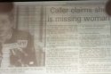
The attached article from the Age, 1998 and clipped by John676 mentions that JR's "watch was found, giving police clues about which they refused to talk. But there is evidence Ms Rimmer was killed and dumped within hours of her abduction".
Additional attached article re JR crime scene mentions that "there had been several items of clothing and a pair of shoes found. They were still being examined but did not appear to belong to Miss Rimmer. Other items had been found at the scene but Insp Ferguson would not elaborate" .


Additional attached article re JR crime scene mentions that "there had been several items of clothing and a pair of shoes found. They were still being examined but did not appear to belong to Miss Rimmer. Other items had been found at the scene but Insp Ferguson would not elaborate" .
Attachments

Innerchild
Active Member
- Joined
- Mar 18, 2017
- Messages
- 957
- Reaction score
- 249
I know most people are sick of the weather debate but think we need to get this correct. I think the big storm metic is talking about was from Friday 24th June which is the only time winds were NW as well, not 17 and 18th June. West and SW swells are protected by groyne and Rottnest Island. Normal sea breeze in summer is 20 to 25 knots, which is fairly strong.
Summary from the West Australian (detailed weather maps attached if interested)
Friday 17[SUP]th[/SUP] June 1988: Temp 16.1 at 10.10 pm and 21.5 at 11.30am
Saturday 18[SUP]th[/SUP] June 1988: Morning showers. Outlook fine. Temp 14 20. West to SW winds 15knots easing to 10 knots by late morning. Seas 1 m on a swell to 2.5 m.
Sunday 19[SUP]th[/SUP] June 1988: Temp min 13.6 at 8.50 pm and max 20.6 at 11.45 am.
Monday 20[SUP]th[/SUP] June 1988: SW winds at 10 to 15 knots easing to 10 knots by late morning. Seas should be 1 m on a swell of 3 m. Temp 10.7 degrees at 7.30 am and max 18.4 degrees at 2.25pm.
Tuesday 21[SUP]st[/SUP] June 1988 Forecast Perth fine and cool. North East winds 5 to 12 knots. Seas should be 0.5 m on a swell to 2.5 m. Temp 8 19 degrees.
Extended forecast: With a high pressure cell establishing itself over the southern half, fine conditions should persist over the State until late tomorrow. A front should approach the coast tomorrow night and cross the lower west coast on Thursday.
Wednesday 22[SUP]nd[/SUP] June 1988 Forecast Fine. Outlook showers developing. Temp 10 20 degrees.
Fine and sunny conditions prevailed through the northern half, while the southern half experienced similar conditions at 4.00pm yesterday. A high pressure system was located over the Eucla and is presently bringing fine weather to almost the whole state. These conditions should persist except for the extreme SW corner where isolated showers are forecast. With clear skies and light winds inland areas should be in for another cold night with local frosts in the southern half. The seasonal fine weather should persist in the northern half.
Extended forecast.
The high pressure system should continue to move east and a cold front is expected to approach the west coast during tomorrow evening. This should bring a renewal of showers to the lower SW. The weakening front should pass through he SW land division on Friday.
Thursday 23[SUP]rd[/SUP] June 1988
Seasonal dry conditions continued in the northern half while fine weather prevailed in the south at 4.00 pm yesterday. Extended forecast: The high should continue to drift eastwards, allowing cold front to approach the SW today.
Friday 24[SUP]th[/SUP] June 1988: A low pressure system in the eastern Indian Ocean has continued to deepen. A frontal cloud band associated with this system has become well defined and is approaching the lower west coast. Strong NW winds precede the front and there are cold west and SW winds off shore behind a second front. The main frontal band should have moved slowly into the SW land division last night and today bringing rain and some thunder storms. Some rain should reach Eastern agricultural areas tomorrow night. The reminder of the state should be fine with above normal temperatures and gusty northerly winds to the east of the frontal region.
Extended forecast: Cold southerly winds are expected to spread into the SW of the state tomorrow night and Saturday behind the fronts. The low pressure system and its fronts, should weaken rapidly in the latter part of the weekend, and a new high pressure ridge should develop fairly rapidly over the SW on Sunday.
North West winds at 20 to 30 knots becoming westerly at 15 to 22 knots. Seas should be 2.5 m on a swell of 3 m.
Innerchild
Active Member
- Joined
- Mar 18, 2017
- Messages
- 957
- Reaction score
- 249
The attached article from the Age, 1998 and clipped by John676 mentions that JR's "watch was found, giving police clues about which they refused to talk. But there is evidence Ms Rimmer was killed and dumped within hours of her abduction".
Additional attached article re JR crime scene mentions that "there had been several items of clothing and a pair of shoes found. They were still being examined but did not appear to belong to Miss Rimmer. Other items had been found at the scene but Insp Ferguson would not elaborate" .
The August 6 1996 article from The Age newspaper said "An autopsy confirmed Ms Rimmer had been dead for about two months." Interesting wording, as it doesn't say they thought she had been at the disposal site for two months. It also says they gleaned a fair bit of information from the crime scene without specifying the watch or other items... and insights into the person we're looking for...
Attachments

Innerchild
Active Member
- Joined
- Mar 18, 2017
- Messages
- 957
- Reaction score
- 249
Some big waves at Cottesloe.
https://terrylyon.photoshelter.com/...ANK&I_DSC_AND=t&V_ID=&G_ID=&C_ID=&_ACT=search

Sent from my HTC 2PQ910 using Tapatalk
How did you get a photo of me surfing there PD?
Spinnaker
Well-Known Member
- Joined
- Jan 23, 2017
- Messages
- 893
- Reaction score
- 449
The August 6 1996 article from The Age newspaper said "An autopsy confirmed Ms Rimmer had been dead for about two months." Interesting wording, as it doesn't say they thought she had been at the disposal site for two months. It also says they gleaned a fair bit of information from the crime scene without specifying the watch or other items... and insights into the person we're looking for...

IMO the clothing and other items found at JR crime scene provided insights into the person they were looking for. Who did the additional clothes belong to? If the perpetrator left the additional clothes there, how did they come into his possession? Snow dropping (similar to the kimono), perhaps from KK attack or from other victims?
Sent from my iPhone using Tapatalk
Innerchild
Active Member
- Joined
- Mar 18, 2017
- Messages
- 957
- Reaction score
- 249
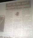
Here's a front view of the same domed roof Change rooms, with Cottesloe Surf Life Saving boat sheds underneath. Indiana tea rooms have been built on that site in the 1990's. Unfortunately, it is a painting so it's hard to see details of the roadway down to the groyne, nor the boat ramps, where Julie Cutler's car may of entered the water.
https://www.aasd.com.au/index.cfm/list-all-works/?concat=bakergreg&order=1&start=1&show=50

Sent from my HTC 2PQ910 using Tapatalk
You won't see the boat ramp as it didn't exist in those days. Skis and boards were kept in the clubhouse and carried down to the ocean. The description in recently posted news paper article from June 1988 describes having to negotiate a one metre drop if the car tried to enter from in front of the boatshed, similar to what is shown in the painting (although sea and sand was very different as shown by the recovery photo).
Car in Surf Mystery Deepens
snipped...The entry point of the car into the water remains a mystery. There was no evidence, such as scrape marks that the car had been driven off the groyne. To drive from the service road around the walkway to the groyne wold have involved negotiating deep sand drifts that have blown across the walk way.
The other most likely entry would be off the service road that leads to the CSLSC boatshed. Such an entry would involve running the car off a 1 m concrete retaining wall, across a narrow stretch of sand into the surf...
Annalise
Well-Known Member
- Joined
- Jul 10, 2017
- Messages
- 711
- Reaction score
- 338
The August 6 1996 article froum The Age newspaper said "An autopsy confirmed Ms Rimmer had been dead for about two months." Interesting wording, as it doesn't say they thought she had been at the disposal site for two months. It also says they gleaned a fair bit of information from the crime scene without specifying the watch or other items... and insights into the person we're looking for...
Hi Innerchild - if JR had been deceased for two months - where was she kept for that period of time? MOO
Canning Vale
Active Member
- Joined
- Apr 11, 2017
- Messages
- 1,487
- Reaction score
- 20
Innerchild,I know most people are sick of the weather debate but think we need to get this correct. I think the big storm metic is talking about was from Friday 24th June which is the only time winds were NW as well, not 17 and 18th June. West and SW swells are protected by groyne and Rottnest Island. Normal sea breeze in summer is 20 to 25 knots, which is fairly strong.
Summary from the West Australian (detailed weather maps attached if interested)
Friday 17[SUP]th[/SUP] June 1988: Temp 16.1 at 10.10 pm and 21.5 at 11.30am
Saturday 18[SUP]th[/SUP] June 1988: Morning showers. Outlook fine. Temp 14 – 20. West to SW winds 15knots easing to 10 knots by late morning. Seas 1 m on a swell to 2.5 m.
Sunday 19[SUP]th[/SUP] June 1988: Temp min 13.6 at 8.50 pm and max 20.6 at 11.45 am.
Monday 20[SUP]th[/SUP] June 1988: SW winds at 10 to 15 knots easing to 10 knots by late morning. Seas should be 1 m on a swell of 3 m. Temp 10.7 degrees at 7.30 am and max 18.4 degrees at 2.25pm.
Tuesday 21[SUP]st[/SUP] June 1988 Forecast Perth fine and cool. North East winds 5 to 12 knots. Seas should be 0.5 m on a swell to 2.5 m. Temp 8 – 19 degrees.
Extended forecast: With a high pressure cell establishing itself over the southern half, fine conditions should persist over the State until late tomorrow. A front should approach the coast tomorrow night and cross the lower west coast on Thursday.
Wednesday 22[SUP]nd[/SUP] June 1988 Forecast Fine. Outlook showers developing. Temp 10 – 20 degrees.
Fine and sunny conditions prevailed through the northern half, while the southern half experienced similar conditions at 4.00pm yesterday. A high pressure system was located over the Eucla and is presently bringing fine weather to almost the whole state. These conditions should persist except for the extreme SW corner where isolated showers are forecast. With clear skies and light winds inland areas should be in for another cold night with local frosts in the southern half. The seasonal fine weather should persist in the northern half.
Extended forecast.
The high pressure system should continue to move east and a cold front is expected to approach the west coast during tomorrow evening. This should bring a renewal of showers to the lower SW. The weakening front should pass through he SW land division on Friday.
Thursday 23[SUP]rd[/SUP] June 1988
Seasonal dry conditions continued in the northern half while fine weather prevailed in the south at 4.00 pm yesterday. Extended forecast: The high should continue to drift eastwards, allowing cold front to approach the SW today.
Friday 24[SUP]th[/SUP] June 1988: A low pressure system in the eastern Indian Ocean has continued to deepen. A frontal cloud band associated with this system has become well defined and is approaching the lower west coast. Strong NW winds precede the front and there are cold west and SW winds off shore behind a second front. The main frontal band should have moved slowly into the SW land division last night and today bringing rain and some thunder storms. Some rain should reach Eastern agricultural areas tomorrow night. The reminder of the state should be fine with above normal temperatures and gusty northerly winds to the east of the frontal region.
Extended forecast: Cold southerly winds are expected to spread into the SW of the state tomorrow night and Saturday behind the fronts. The low pressure system and its fronts, should weaken rapidly in the latter part of the weekend, and a new high pressure ridge should develop fairly rapidly over the SW on Sunday.
North West winds at 20 to 30 knots becoming westerly at 15 to 22 knots. Seas should be 2.5 m on a swell of 3 m.
The fiat went in the ocean between Monday 20 and Wednesday 22 June. Yet you’ve provided weather conditions commencing from Friday 17[SUP]th[/SUP] June.
Are you suggesting the weather conditions couldn’t have caused the damage to the Fiat?
As this information is being posted – ongoing. Could you please provide a summary of why that is? What is it that you are trying to convey?
- Status
- Not open for further replies.
DNASolves
Online statistics
- Members online
- 116
- Guests online
- 2,158
- Total visitors
- 2,274
Totals may include hidden visitors.