PD, thanks that right , the statistics for Subiaco are at least real data .
Unless innerchilds info is recorded statistics? Its irrelevant now , just a throwaway .
Historical weather stats are all that matter, 29 years later, now .
BTW newspaper weather is about the most basic level weather info you can get .
Very generic and lacking in detail compared with whats actually available.
Dont put faith in the old basic newspaper weather , if you are really keen on understanding weather you go way further beyond and into higher level information.
http://www.transport.wa.gov.au/imarine/cottesloe-tide-and-wave.asp
http://www.transport.wa.gov.au/imarine/rottnest-island-tide-and-wave.asp
Links to directional swell graphs
Showing Norwest swell mon 16th oct 2017
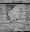
As stated in previous posts and on images sources, all weather readings accurate readings from the day after unless otherwise stated from The West Australian June 17 - 23 1988.
The West Australian had very accurate weather in 1988. The West published yesterday’s BOM isobar, mean sea level charts (MSL) and today’s MSL outlook. Detailed forecasts with clear image of state with detailed forecasts for each area. Detailed, extended forecasts, and small boats wind, sea and swell reports.
The boating forecast was very important and relied upon by many before the days on Internet access to BOM. Monday 20th June
SW winds at 10 to 15 knots easing to 10 knots by late morning. Seas should be 1 m on a swell of 3 m. But what does that matter if the Fiat only entered the ocean on 22nd June and was found a matter of hours latter with its lights on.
Temperature and yesterdays confirmed temp with times for max an min, Capital city temps, tides in all cities in the state, moon phases, sunrise and sunset. All of this took a whole page and had all the BOM date.
What I find interesting is that your posts one day, when reading the MSL chart form the West Australian for 17th of June said the chart indicated there was a storm approaching. That is incorrect. The next post agreed there was no storm indicated with the MSM chart and yet a day later you were posting that the same MSL chart for the 17th June showed there was a storm coming. Incorrect.
Even if you can't read the MSL charts they are clearly explained in the extended forecast from The West Australian, (as well as temp info etc) from the .jpg. The information is all correct and I have followed websleuths rules carefully with this.
The minimum temperatures from Subiaco are slightly different (Fremantle was in operation then), but minimums weren’t until 7 or 7.30 am on the 20[SUP]th[/SUP] - 22[SUP]nd[/SUP] June 1988. Source The West Australian. Depends where you're from. In England 10, 11, 12 degrees could be a summer's day and yet was most probably the overnight temperature on 20th June 1988. Your Subiaco station didn't have a source which you could have easily google and put it in your post.
http://www.bom.gov.au/climate/data/stations/
Data which I have posted here and previously from images and notes taken, shows no storm before 20th June, fine light winds, SW to NE from 20th to 22nd June. Storm not coming in until after 24th and probably on 26/27th June. I didn't both looking that far ahead as it has no influence on JC's Fiat at Cotteloe beach.
Source: The West Australian Tuesday 21st June 1988
Source: The West Australian Saturday 18th June 1988.
All post are my personal opinion and my personal copyright u
nless sources are included