Bartholemeus
Former Member
- Joined
- Dec 21, 2013
- Messages
- 1,498
- Reaction score
- 21
I have some questions;Hey there,
I just signed up after recently reading The Devil's Garden, I've read/skimmed some of the threads about this case and think I have some understanding of people's general theories. I haven't got a clue who did it, but I am certain it can't be all the POI's.
I was thinking about known facts and maybe I am wrong, but from what I can tell the main things we know are 3 women went missing after being out in Claremont, 2 of whose bodies were found at opposing ends of Perth. The killer must have had access to a car of some descrption.
One thing in the book I found interesting was geographical profiling for serial crime. I did some googling and found there is quite a lot about some of the techniques and formulas they use. One such paper is http://www.math.washington.edu/~morrow/mcm/7272.pdf. It discusses 3 methods and a hybrid which I wanted to check out. To summarise they are:
1. Great Circle - take the 2 furthest crime points, find the middle and draw a circle. The idea is the criminal will live within the circle..
2. Centrography - Take the mean of the x coords and y coords of each crime to find the centre of mass for the crimes. However this centre does not take into account that there is often a buffer zone betweeen where a criminal lives and where they operate.
3. Rossmo’s Formula - Criminals won't travel too far to commit crime. There is a buffer zone around criminals residence where crimes are less likely be committed. Probabilty of living based on grid of crimes. I don't really understand the maths.
4. Gaussian Rossmooth - Hybrid of Rossmo's formula - I definitely don't understand this..
Rossmo's Formula requires 5 crimes before it should be used. Unfortunately more crimes means more data points. If we include Claremont and the cemetary rape (was it really CSK?), you could say we had 5 crimes or 3 abductions plus two body sites is 5 too, but since I don't understand the maths........
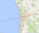
I don't know the exact loaction of the sites Jane and Ciara were found, nor do we know exactly where they "went missing" so I have taken approximate locations based on what I have read.
Jane -32.264423 115.859806
Ciara -31.584123 115.648691
Claremont -31.982219 115.781233
And I did a hybrid of Great Circle, Centrography and wanted to take into account a buffer zone based on the above 3 points.
The sites Jane and Ciara were found in is 78km apart as the crow flies. This mid point is on west coast highway 71 (WCH) about 200 meters north of The Blvd. The distance between sites by road of an example route via WCH is approx 92.6km. Which is give or take about 101 mins driving according to google maps. The halfway by this route is on WCH somewhere near Rochdale Road. The mean (centrography) of claremont Jane and Ciara is on WCH a couple of hundred meters south of Oceanic Drive.
I've plotted these points here: https://www.mapcustomizer.com/map/claremontlocations
And I got out my compass out and did the following:

I originally added in a route via mitchell freeway as google said it was quicker, but after thinking about it, would you really drive into the city after abducting someone, if you didn't have to? I think you would drive carefully at the speed limit on moderately used roads and avoid points of possible congestion (even in the middle of the night).
Taking into account a buffer zone, I wonder if the CSK lives north of City Beach in the 6km radius of the midpoint between Jane and Ciara. (yeah I know, it may as well be half of perth....)
Since, I've just signed up, I haven't been able to see the upload images etc, so if someone has already post this type of thing and I have missed it, I apologise. I found it an interesting exercise nonetheless.
1. Why a 39km radius and a 45km radius of dump sites? How did you choose these 2 distances?
2. Should it be from the dump site or the abduction site or the kill site?
I'm going to go have a look at those theories to see if I can make anything out of them.
On City Beach - maybe, but back then and even now, although the area is close to Claremont, they're apart. The West Coast Hwy extension wasn't built until the late 80s and before that there was even more of a gap. Basically the areas aren't connected by public transport. The whole feel of the areas is different. The only City Beachers who socialised in Claremont would have been the handful of private schoolers who had friends in the Claremont area. My gut feel is the CSK was more local. Subiaco to Mosman Park.
On the distance between dump sites - I think this is more about the CSK choosing a place on the fringe of the city rather than a geographical distance from his residence. I do however think the locations suggest he is central - roughly equidistant north and south, but western suburbs rather than eastern suburbs. I think if he lived North of City Beach he would have been more inclined to dump all girls North, North East etc.