:welcome:
Thank you very much for pitching in! You made my morning as I was wishing for you! It's great to have a local eyes willing to consider possibilities. The spaghetti you throw against to wall has a better chance of sticking.
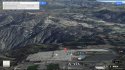
Thank you so much for pitching in. We'll get your suggestions on the map. If I may impose on you when you have a minute, I've found as I often am too stubborn to use GIS devices and prefer maps which aren't always on hand, I try to figure it out. So, sometimes I end up in places that are dead ends, or tricky to get out of. Would you happen to know of easily mistaken turn-offs that may have lead them to a dangerous edgy spots. Then assuming they drove at least fifteen minutes out, what roads would put them in cell signal dead zones within fifteen minutes on which they would not have made it on long enough to not ping again? I realize these are kind of dumb to ask but I'm trying to whittle down to some possibilities, especially with locals who may know what it will take to find them.
updated 4 min ago
https://www.facebook.com/MissingPaulandDianna/posts/986935044663881
"There are a lot of speculations on them winning a large Jackpot.... They lost 50 dollars"