margarita25
Well-Known Member
- Joined
- Oct 10, 2012
- Messages
- 51,426
- Reaction score
- 207,163
Maybe he's mad at eharmony, got a bad match (see map). Sorry, this map is making me delirious.

Follow along with the video below to see how to install our site as a web app on your home screen.
Note: This feature may not be available in some browsers.


Forager, can you please give me a lateral mile distance between 287 and Romero / roof incident? TIA
Highway 287 is 4.75 miles to the west of I-25 in that area.
We had another pair of incidents a couple of months ago: one vs. a semi on Hwy 34 in Morgan, another on C-370 in Morrison, both on 8/31/15. Both pairs were on the last Monday of the month. (The times of day were very different, though: 4:19 PM and 5:13 PM for yesterday's attacks, and 7:20 AM and 9:00 AM for August's.)
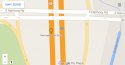
The northern sunroof shattering location is described as the underpass between Mountain Vista and CO 14. That would be where Vine St. crosses I25, about a mile south of the location shown on the map.
There is often heavy traffic at the intersection of Harmony and I25 in the late afternoon.


rsbm

I posted on this thread a while ago and came back to it today because I read in the paper about the sunroof shattering. We are living in a house not far from Harmony. Gosh, how scary. I'll try to contribute some once I get to know the area better. Thanks for the great sleuthing!
")
Peak traffic times on a major highway, and nobody saw anything...
To hit a sunroof, one would have to be firing down onto it...
Lol, don't laugh at my image :blushing:
Potential routes, not counting back roads inside?

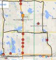
Here are tighter zooms of the two spots, starting with the earlier one, on the assumption that it was just south of the Harmony Rd. overpass. I've put littles scales in in blue to show what 300 feet (one football field) looks like.
View attachment 83426
The second attack by the Mountain Vista overpass:
View attachment 83425
I would have felt terribly exposed with a gun or airgun on that overpass or its escarpments in the late afternoon. Am I wrong, Coloradoans, to think that someone on foot in those areas would have stood out like a sore thumb? I would have wanted a getaway car and driver at the ready before I tried that.