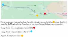
True Crime Tour – Day 2
After enjoying an evening in Salida, I travelled the route from the former Morphew residence on Puma Path to the burial/dump site south of Moffat. [Side Note: I can recommend the pie at Moonlight Pizza, which, you may recall, figured tangentially in Mr. Morphew’s “explanations” for his various actions during the days leading up to Suzanne’s murder, Arrest Affidavit pages 22, 90.]
Google shows the route requiring 53 minutes (52 miles) but it can easily be travelled in far less. From Poncha Pass to Moffat is a arrow-straight road in excellent condition and I was able to travel this stretch comfortably at 90 mph (though I didn’t maintain that speed for the entire way due to LE concerns). Travelling late at night (say well after midnight) when concerns about LE would be minimal, it would be possible to travel at a speed of 100 +/-. So, if in the early morning hours of Mother’s Day, 2020 Mr. Morphew was in a hurry, as one might surmise, he could have made the round trip in 80 minutes or less. This would have given him more time to clean up the house and/or stage evidence.
I also observed that along the route below Poncha Pass there are few if any places to pull off the highway that aren’t gated or have a business/ranch/house close by. Presumably, one wouldn’t want to dig a shallow grave anywhere near an area where human ingress and egress was common (it would be more likely to be quickly discovered). All of the stretch of the road from the pass down to Moffat is fenced on both sides.
The burial site off County Road R, about a mile south of Moffat is the first turnoff I saw that doesn’t lead to an area of human activity. Whether this was a selection criterion on the fly or was a spot known to the perpetrator in advance, is not clear to me, however, something seems to be going on in the area where Suzanne was left.
There is currently an old, trashed, abandoned trailer and two shipping containers just off the road within about 100 feet of the burial site but with no power so, no lights (photo below).

The trailer and containers do not show up on the current google earth or google map satellite views (which are dated 2024). Moreover, there is a very recently built, secured fence around these features (pic below) and I noted two survey flags (?marking evidence locations?) inside the fenced area (photo below). What this is all about, I haven’t a clue.


A couple other observations of the burial location:
- Looking around there is a lot of very old metal trash including cans, pots, bottles and the 1923 license plate shown below. There were also some hunting remains (a severed hoof and cleanly cut leg bone) suggesting hunters may have used the area.
- The soil at least to a depth of about a foot is a very soft silty material; very easy to dig. This suggests the shallow depth of burial may have been due to an extreme rush, not difficulty digging.


I’m sure LE has thoroughly evaluated this area and may have found some significant evidence (circumstantial or otherwise).


")