I feel like I'm missing something factual...I think you nailed it, including the red X.....moo

Install the app
How to install the app on iOS
Follow along with the video below to see how to install our site as a web app on your home screen.
Note: This feature may not be available in some browsers.
You are using an out of date browser. It may not display this or other websites correctly.
You should upgrade or use an alternative browser.
You should upgrade or use an alternative browser.
Found Deceased IN - Abigail (Abby) Williams, 13, & Liberty (Libby) German, 14, The Delphi Murders 13 Feb 2017 #106
- Thread starter Tricia
- Start date


New Posts
-
 Australia - Erin Gilbert, 42, murdered, Merrylands, Sydney, 9th April 2023
- Latest: TootsieFootsie
- Status
- Not open for further replies.
You did good. Thanks for sharing it....mooI feel like I'm missing something factual...
mtnlites
President of the Imaginary Friends' Club
- Joined
- Nov 12, 2014
- Messages
- 4,588
- Reaction score
- 43,454
And really, there's nothing to say he was "seeking" anybody that day, either. Maybe he was, but he could have simply seen the girls on the trail, or being dropped off, and it tripped his trigger.
Yep. We've seen nothing to support the idea that this was planned. That doesn't mean it wasn't, but it also doesn't mean it was. Despite talk of the "murder kit" he may have had on him, it's all just speculation. We don't know what he was doing there that day. He may have gone there seeking someone or it may have been a spur-of-the-moment kind of crime. We just don't know. My husband carries a small backpack with him everywhere he goes. It has general first aid items in it, but he also carries at least 2 knives, some matches, some twine, etc. We live in the country. He finds a use for his items almost every day. BG could've had something like that on him-or maybe he didn't at all.
Jerrod
Well-Known Member
- Joined
- Oct 28, 2016
- Messages
- 427
- Reaction score
- 2,362
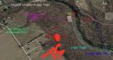
So, here's a map I made for myself, but I'll share. Tell me if anything needs changed. This is representing only what I think is fact, based off what LE has stated.
Yellow question mark: CPS building - may or may not be related to crime.
Yellow asterisk: Where the girl's were dropped off.
Red X: Where BG was videoed walking the bridge.
Red (crappily drawn) circle: somewhere within is where the girls were found.
You may want to compare your map to the highly comprehensive and accurate one prepared by @skibaboo. It's supported by numerous links so as to be essentially irrefutable.
Abigail Williams & Liberty German. Delphi, IN. 2/13/17 - Google My Maps
Cutiekitty
Well-Known Member
- Joined
- May 5, 2019
- Messages
- 765
- Reaction score
- 4,744
Unfortunately some of these applications like Kik, Whisper and WhatsApp don't leave much trace. That's why predators use those type of apps.
Same with SC.
Jerrod
Well-Known Member
- Joined
- Oct 28, 2016
- Messages
- 427
- Reaction score
- 2,362
It's long ago. I see the open barn with the flowers at a certain place in front of my inner eye. Once I saved the pic, but it's gone meanwhile. Maybe, because someone said at the time, it would be rumor and maybe I gave up.
I have that pic. It's definitely the M**rs barn, but when the flowers were put there - and by whom - is up for debate. It does seem to be supported by the video from WTHR 13 showing a search dog and its handler snooping around the entrance to the barn (directly across the road from Mr. Logan's residence).
Last edited by a moderator:
Angelcat13
Well-Known Member
- Joined
- Apr 7, 2014
- Messages
- 549
- Reaction score
- 4,645
What is the distance from where Abby & Libby were found to the old CPS building? I know there were some maps at some point but I have no idea where in these umpteen pages of threads they are at this time. Does anyone have a simple overhead map that shows the bridge, where the bodies were found, the cemetery and the old CPS building - ideally with distances marked?IN - Abigail (Abby) Williams, 13, & Liberty (Libby) German, 14, The Delphi Murders 13 Feb 2017 #106
Post 1156
I measured on google maps this morning as shown, from the south road of the cemetery to the water edge is 716 feet, but that’s google maps, maybe it’s not calculating correctly.
Thanks!
Cutiekitty
Well-Known Member
- Joined
- May 5, 2019
- Messages
- 765
- Reaction score
- 4,744
Just nitpicking other variations of information -
The family says the girls were dropped off at about 1:45pm, yet the FBI continues to report it was about 1pm. I wonder why that is.
I also notice this says the bodies were discovered “appx 1/2 mile upstream from the bridge”. From which end of the bridge? Does 1/2 mile upstream from where the bridge crosses Deer Creek place the location south of the cemetery?
Kelsi said 1:35, BP said around 1:38, and GH said 1:45. It’s all basically within the same time period, but I get what you are saying about the info out there. The m not going to start up again about the 2:07 SC pic (you know how I feel about that). LE really hasn’t released very much.
They could still charge him as an adult.I have been wondering if the LE have a firm suspect who was under 18 at the time and are quietly building a case and waiting until he is no longer a juvenile before charging him with the crime. I'm not sure if that was the case would it may any difference to his sentence under Indiana Law.
ETA Hadn't finished typing before posting
So hopefully somebody else can do a more comprehensive map for you, but to give you an idea.What is the distance from where Abby & Libby were found to the old CPS building? I know there were some maps at some point but I have no idea where in these umpteen pages of threads they are at this time. Does anyone have a simple overhead map that shows the bridge, where the bodies were found, the cemetery and the old CPS building - ideally with distances marked?
Thanks!
The zero on the measurement is the approx. spot the girls were found according to the skibaboo map Jerrod posted above. And I just measured a straight shot through the woods to the CPS building (not marked, but at the end of the measurement). It's just over 5000 ft. Both maps are the same, one road, one satellite.
Attachments


Cutiekitty
Well-Known Member
- Joined
- May 5, 2019
- Messages
- 765
- Reaction score
- 4,744
I disagree. He wouldn't have to be "very lucky" to run into females, either alone or with a friend, in the park. It's a popular place and there's almost always someone there. Even the Patty's have stated that there were around 20 people there at one point during the afternoon. I go there alone, I know others who go there alone (or used to, anyway). He may have just been seeking one victim, but when he saw the girls together he underestimated them and thought it would be easy to attack them both since they were kids.
Looking at their social media information would've been the first thing LE would've done once their bodies were found. The FBI and Indiana State Police are involved in this investigation. Literally some of the best minds at Quanitco.
Bbm- True, but the problem with SC is the information is only retained under certain circumstances and only for a short time period. The girls weren’t found till 12:30 the next day.
mtnlites
President of the Imaginary Friends' Club
- Joined
- Nov 12, 2014
- Messages
- 4,588
- Reaction score
- 43,454
I have that pic. It's definitely the M**rs barn, but when the flowers were put there - and by whom - is up for debate. It does seem to be supported by the video from WTHR 13 showing a search dog and its handler snooping around the entrance to the barn (directly across the road from Mr. Logan's residence).
There are definitely pictures of the flowers at the barn, but as you said, we don't know who placed them there-or if anyone did. There was also some speculation that they simply blew in from somewhere else.
My whole thing about that is that if the girls were taken to another location the it stands to reason that THAT location would also be taped off. And the barn wasn't.
Last edited by a moderator:
Spartygirl
Verified Insider - Michael Vanzandt case
- Joined
- May 3, 2016
- Messages
- 4,661
- Reaction score
- 46,338
Here is a map that shows measurements by feet around bridge and crime sceneExcept isn't that downstream, not upstream? Or am I being an idiot?
That spot would be about a 1/3 mile hike from the south end of the bridge.
")
Attachments
HockeyMom330
Well-Known Member
- Joined
- Feb 23, 2017
- Messages
- 262
- Reaction score
- 2,144
Hmm okay. IIRC BP stated during various interviews the girls were only allowed to go to the bridge if they were able to find somebody to drive them there and drive them back. But KG is saying there was no ride prearranged to go home until after she brought them there??? That seems sort of contradictory....because had DG not agreed to pick them up, what then? Do you recall the source as this is new and different information.
Unfortunately I can't remember the source, but I recall watching an interview with BP in which she stated that she gave the girls permisson to go to the trails under two conditions: (1) they arrange a ride to and from the trails; and (2) Abby asks permission from her mom. Without directly saying it, BP goes on to imply that she was somewhat negligent in checking with the girls that they had satisfied both conditions before they left...she assumed they had when in fact they had not.
KG agreed to drive the girls to the trails on her way to her boyfriend's house before work. BP told Libby to bring a jacket, but she refused. While on their way to the trails Libby phoned her dad, DG, to ask for a ride. BP said something to the effect that he would do whatever she asked and was always there for her, so LG knew that he would pick them up no matter what, but she also speculated IIRC that KG would have likely turned around and brought the girls back home if DG refused or was unavailable. DG did agree to pick them up though on his way back to town.
I've never been clear if Abby contacted her mom, or perhaps tried to but could not reach her as she was at work. Anna seemed surprised and upset to learn that Abby had been on the Monon High Bridge when she saw the SC photo, as she did not have permission to cross it...but maybe she had permission to be at the trails.
mtnlites
President of the Imaginary Friends' Club
- Joined
- Nov 12, 2014
- Messages
- 4,588
- Reaction score
- 43,454
They could still charge him as an adult.
Right. If the crime is heinous and the perp can be considered a danger to the community at large, children as young as 14 can be tried as adults in Indiana. I can't see them holding off on an arrest because of his age. There'd be no reason to.
FinePrint
Well-Known Member
- Joined
- Jan 18, 2019
- Messages
- 941
- Reaction score
- 7,780
BumpJust for the heck of it I mapped out the possible route from the crime scene (approximately) to the Old CPS building. If BG left the crime scene and got back on the path and headed west, north west towards that CPS parking lot it measures just over a mile. Distance from the crime scene to the trail head where the girls were dropped off is approximately 1/2 mile.
This is my interpretation, opinion only and in no way an official map. Just thought it may help some wanting to see the locations mapped out.
View attachment 189561
Spartygirl
Verified Insider - Michael Vanzandt case
- Joined
- May 3, 2016
- Messages
- 4,661
- Reaction score
- 46,338
But then you are on private property back there on the S end, IIRCYou could technically keep going, although there is a gate of sorts. (And yes, there IS a gate that extends across the dirt path. It's on past the two poles, though there's nothing on either side of the gate so one can easily walk around. It's meant to sway 4 wheelers.) There's nothing beyond it, though. It's even a real "path" after you go on past the poles.
mtnlites
President of the Imaginary Friends' Club
- Joined
- Nov 12, 2014
- Messages
- 4,588
- Reaction score
- 43,454
But then you are on private property back there on the S end, IIRC
Yes, of course. I've stated this before. I was replying to the question about whether it was possible to continue going forward. Technically, yes. It is possible. You can walk around the gate or past the poles. There's nothing there to physically deter you. But the trail ends after about 15 feet and you're on private property.
FinePrint
Well-Known Member
- Joined
- Jan 18, 2019
- Messages
- 941
- Reaction score
- 7,780
I just reposted ( bumped as I’m not that savvy on this device). From approximate crime scene to the CPS building I measured just over 1 mileWhat is the distance from where Abby & Libby were found to the old CPS building? I know there were some maps at some point but I have no idea where in these umpteen pages of threads they are at this time. Does anyone have a simple overhead map that shows the bridge, where the bodies were found, the cemetery and the old CPS building - ideally with distances marked?
Thanks!
Thelastleg
Well-Known Member
- Joined
- Jun 2, 2019
- Messages
- 375
- Reaction score
- 1,655
What I'm getting at is if he was charged as an adult would the sentence be more severe than if he had been charged as a juvenile. Would there be a benefit in waiting to make sure that he got the maximum sentence.They could still charge him as an adult.
- Status
- Not open for further replies.
DNASolves
Online statistics
- Members online
- 65
- Guests online
- 989
- Total visitors
- 1,054
Totals may include hidden visitors.