I wonder if the picture of the POI was taken intentionally by one of the girls using the "selfie" camera side. Perhaps the girls realized they were being followed and pretended to take a picture of something in front of them while actually taking a picture over their shoulder. Kids are very good at sneaking pictures with their phones, especially using Snap-Chat. My teenage son aggravates me taking my picture without me realizing it usually to send to his friends on Snap-Chat..

You are using an out of date browser. It may not display this or other websites correctly.
You should upgrade or use an alternative browser.
You should upgrade or use an alternative browser.
IN - Abigail Williams, 13, & Liberty German, 14, Delphi, 13 Feb 2017 #4
- Thread starter 0101ABA
- Start date
Welcome to Websleuths!
Click to learn how to make a missing person's thread
Click to learn how to make a missing person's thread


- Status
- Not open for further replies.
SouthernMom
Well-Known Member
- Joined
- Jul 29, 2008
- Messages
- 1,194
- Reaction score
- 3,609
I have been trying to keep up but missed they were killed separate days.... is that linked on the first post? Let me go see [emoji30]
Sent from my iPhone using Tapatalk
I believe there is some confusion stemming from the differences in death date in the girls individual obits. Could be mistakes or just difference in the TOD ( time of death) on the individual death certificates. Hate to type this, but that could be just that the girls were there, but the perp didn't realize that he had left one still breathing.
Jethro4WS
Well-Known Member
- Joined
- Jun 27, 2016
- Messages
- 6,054
- Reaction score
- 35,240
Based on what I have seen from screen captures from the helicopter video and the photographs of where they were found (at least part of the area crime scene taped off):That's why I questioned how quick in/out from the cemetery.
There is a path that goes north from the crime scene (there is a photograph looking down toward the crime scene) to another path that likely runs east-west (can see vehicles there in a photograph looking up). From the cemetery there is a path at the southeast corner that likely heads down to the east-west path. So it doesn't look like it is all that difficult or lengthy traversal. A few minutes each way I suppose.
Deltucky
Former Member
- Joined
- Jul 25, 2016
- Messages
- 777
- Reaction score
- 35
Would it be possible that the photo guy is a rail worker whose train was at this facility loading or unloading - he knows he's got 1-2-3 hrs to kill waiting for the train, so he goes on a nature walk - possibly having been here before or even regularly, he crosses the road and takes the trail to the bridge. Then he's back on the train and out of town by dark or earlier. This would not necessarily explain the search at the house earlier in the week. But if you found out what if anything shipped by rail from this location that day, times, rail lines and crew, you never know what you might find.
Because we know so little, anything could be possible. I think it's more likely than some of the theories presented so far; but what do I know?
carpeverum
Member
- Joined
- Jun 30, 2015
- Messages
- 247
- Reaction score
- 55
The more I study the picture of the suspect, I think the first photo he is not wearing a hat. I think it is his hair and the second photo he has the hood of his hoodie up over his head.
YES! I just returned from looking at photos (again) and I agree!!
In fact: it appears as though he is quite young with a chubby teen or young adult face. Looks like he has short-to-medium length dark sandy-blonde hair.
liltexans
Retired WS Staff
- Joined
- Jan 4, 2011
- Messages
- 13,451
- Reaction score
- 25,916
So are there any cameras on the roads near this trail? No vehicles of interest so now LE is looking for hitchhikers? Doesn't seem promising. At least LE is communicating this to the public. Residents need to keep their kids indoors. Women should keep their alerts up too. Check their properties for anything strange or missing. Footprints, dogs barking, etc.
I wonder if they found a man's footprints leading away from the area the girls were found that end at one of the roads. Or maybe the search dogs picked up a stanger's scent and it ended at one of the roads. It sounds like LE does not think the perp drove himself away from the scene.
Some tech savvy people have mention that the cameras "create" filler pixels for low resolution cams. If that's so, we could be sleuthing details that are much of nothing, literally.
Sent from my XT1254 using Tapatalk
I completely agree! When my son was in Marine boot camp pictures were posted by other mom's there for their child's graduation (seeing other platoons marching, etc) or the USMC site. Granted, yes, they all looked very similar but a Mom KNOWS her son right? I'd blow those suckers up so big the face had little definition and I was convinced, "there's my boy!". I saved these photos. When my son came home I showed him...not only was it not him, it wasn't even his platoon!!!! Your mind can really play tricks on you. I wish so badly this picture circulating was more clear. I think it's best to look at not blown up. There's more definition for sure. Great work though sleuthers.....this case is horrific!
skibaboo
Mrs Map
- Joined
- Oct 31, 2011
- Messages
- 10,705
- Reaction score
- 4,980
Is there another Facebook group to follow/read, other than the main one for Websleuths? There must be, because the Websleuths Facebook only had a few posts about this case. Thank you if someone can re-share the Facebook group.
https://www.facebook.com/groups/1213421292107619/
It's a closed group, you need to join to read it
Hatfield
Well-Known Member
- Joined
- May 3, 2012
- Messages
- 17,014
- Reaction score
- 59,129
A couple pictures of the bridge. It shows how wooded the area is.
Sorry if already shared before.
https://www.indianalandmarks.org/endangered-property/monon-high-bridge/
[url]https://www.flickr.com/photos/historic-landmarks-foundation-indiana/sets/72157667545100136/
[/URL]
Some show a horse drawn wagon and I think a steam locomotove from years past.
Sorry if already shared before.
https://www.indianalandmarks.org/endangered-property/monon-high-bridge/
[url]https://www.flickr.com/photos/historic-landmarks-foundation-indiana/sets/72157667545100136/
[/URL]
Some show a horse drawn wagon and I think a steam locomotove from years past.
Looking at my post I realise I'm unclear. I agree. I believe it to be hair. Thick, light brown hair with sort of bangs. I'm still out on facial hair. Resolution isn't good enough for that. He looks very much like my next door neighbor with his dated haircut (I'm on Long island in NY so I'm not calling it in lol).
Sent from my XT1254 using Tapatalk
Agree, the first photo looks like Ross Harris' hair to me... Thick, light brown, side part... The second looks like the hood is up.
oceanblueeyes
Well-Known Member
- Joined
- Jan 2, 2004
- Messages
- 26,446
- Reaction score
- 43,719
I still haven't honed in on the type of person I think this guy is. I keep wondering if he is someone the girls knew, someone they at least recognized if not acquainted with. He knew he had to kill them because they could identify him. Once he decided to attack them, he knew he had to bring it all the way to murder.
Other times, I think it was someone who stalked one/both of the girls and either knew they would be at that place on that date, or had catfished them into a meeting.
I just don't have a handle on the guy yet.
The possibilities are endless. Imo, they did not know this man. I still think this was a crime of opportunity when he saw two young teen females alone with no one else around. If they knew him even slightly then either their families or friends would have known him too and IDd who he is by now.
No longer does the murderer have to know their victim/s for the victims to be murdered. Many cases have been done by complete strangers who will murder their victims so they cant tell anyone what happened to them or by whom by giving a detailed description of their attacker.
More and more it seems murderers think silencing their victims is in their best interest. They seem to think their victims have no human value and are expendable.Its all about protecting themselves by not leaving a living witness behind whether they knew the victims or they did not know them at all.
The motive for these two murders , imo, was to sexually assault them. Once he did that, he murdered them. IMO
NewMama
Well-Known Member
- Joined
- Aug 1, 2012
- Messages
- 1,094
- Reaction score
- 1,893
"We are actually expanding out. We want people who may have seen somebody walking, that may have picked up a hitchhiker, that may have seen a hitchhiker around that afternoon of Monday, [Feb.] 13, Riley said."
Trying not to be discouraged by this. Wondering if they've looked at surrounding surveillance footage & don't see anything that could potentially be related. Or if they see someone fitting his description leaving on foot.
I'm also curious if these stills were taken from a video if LE can't get a composite sketch based off any remaining footage.
http://wlfi.com/2017/02/20/sgt-riley-search-expanding-for-wanted-man-in-delphi-double-homicide-case/
BunnyHop
Former Member
- Joined
- Jun 1, 2012
- Messages
- 3,689
- Reaction score
- 26
Photo of mysterious suspect prompts calls 'from everywhere' in Indiana teens' murder probe
http://abcnews.go.com/US/calling-probe-murder-indiana-teens/story?id=45610075
http://abcnews.go.com/US/calling-probe-murder-indiana-teens/story?id=45610075
Considering
Well-Known Member
- Joined
- Apr 3, 2012
- Messages
- 2,262
- Reaction score
- 3,034
Anyone know if there an old bridge anywhere in the vicinity of where L&L were murdered?
If I recall correctly from the Evansdale case, there is/was at least one old bridge at Seven Bridges that was no longer in use. It was on an old road into the park.
trenchmouth
Former Member
- Joined
- Apr 13, 2013
- Messages
- 673
- Reaction score
- 40
I think his right foot shows mostly the front and some of the inside of his shoe. When I first looked at it looked like his foot was rotated out almost 90 degrees and the white band is on the side of shoe. However I now think the white band is actually the front of his shoe and is the midsole. The black area below the white or light midsole must be a shadow. Follow me?Not sure now, if we are looking at the sole or the top of the show. The yellow marks could be the lace keepers/ eyelets. It all depends on how you see the movement of the foot. Comparing it to the other foot, this makes more sense:
The white mark on his right shoe could therefore be the inside of his boot rather than the front top. If you look at his right knee, it looks like it is turned slightly to the outside:

What do you think?
-Nin
Sent from my 2PS64 using Tapatalk
kirkassoc
Well-Known Member
- Joined
- Feb 20, 2017
- Messages
- 1,207
- Reaction score
- 6,788
According to what I have read regarding this case, they were dropped off at approx. 1-1:30 pm. They were to be picked up at 3-3:30 (IF whomever was to pick them up arrived on time). They were reported missing at 5:30 pm. The photo (if the times are correct) was taken at 2:07 pm. That would only give the perpetrator a very small window of opportunity to do what he/they did (2:07 until 3-3:30. I say 3:30 because the fact they didn't show up to be picked up says they were already at the crime scene, IMHO). Another thing that puzzles me is what the news reported about the crime scene (it was "unusual"). Also, they mentioned finding them beneath "two hills." Were they not together when they were found? Was one killed first and then the other and located close together but not next to each other? One other thing I would like to mention is, the first time I saw the POI photo, I thought he had a small "goatee." Also, I believe he is an older man because of the way his jeans fit (at least 45 or older). These are just thoughts I have had while hoping and praying this monster is caught.
I understand where you coming from. But...I personally think its absolutely unacceptable if LE called off the search. Hunters search for deer in conditions just like that, in the dark and cold. If a hunter can search for a deer, LE can search for a child. Just my opinion.I understand the frustration with the loss of these girls. I feel like the search was called off to protect searchers and LE. It was cold, dark, and treacherous. There was a body of water and ravines. No lights. It's super frustrating they weren't found in time, but it doesn't help searches when you have to rescue or help the people searching. Unfortunately, the area and time of year didn't accommodate for overnight searching.
Sent from my iPhone using Tapatalk
Sent from my SAMSUNG-SM-N920A using Tapatalk
Bob Saccamano
New Member
- Joined
- Feb 16, 2017
- Messages
- 95
- Reaction score
- 41
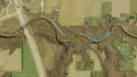
Sorry for the obsession with aerial maps, but the thing I've had the hardest time with regarding this case is the logistics-
I am interested in how the perp accessed and exited the area because I feel this speaks to planning and familiarity. I'm assuming he used a vehicle, so he had to park it somewhere. On a broad level, he could only park East or West of the bridge/trail and North or South of the river.
Initially, I felt the most likely place to park would be the SW corner of the cemetery in the wooded area. This makes sense because it provides for some cover, it is an area that isn't too alarming to park a car if someone happened upon it. It also requires the least amount of foot travel to the bridge and out of the area after the crime and is the main reason that I feel this would speak to planning as I would imagine he'd want to exit the area quickly after committing the crime. This positioning of a vehicle would render it unnecessary for him to cross the bridge at all, but doesn't mean that he wouldn't do so to blend in or to get in a position that he felt he could best intercept them. It could also be a situation of random opportunity, but that would raise different questions. At this point, I feel this position of a vehicle to be one of the more likely ones, mainly because I feel he took them to where he did for some reason and part of that would have to do with being able to escape unnoticed. This position would mean he would have the least likelihood of coming into contact with a witness after the crime because it wouldn't require him to cross the trail or get near the bridge before leaving.
The 2nd most likely position to park a car is one that I didn't notice at first until I zoomed in. There is a driveway off of W 300N that intersects the monon bridge trail. I've shaded it in white. Looking closer, it crosses the trail and appears large enough for a vehicle. It goes roughly parallel to the monon trail down toward the river. I remember one of the witnesses interviewed that saw a man, but not the girls, mentioned that she did not take the trail to the right. At first I assumed that meant the trail that intersected the bridge trail on the south end of the bridge, but it could actually be the shaded trail on the North side of the Creek. If one were walking toward the bridge, it would be on the right. It does appear to me that someone could have driven a car down there, but it would be a little more conspicuous if a witness were to happen upon it. This position would also require the perp to cross the trail after the crime to get back to his car and pull out of the area where it is possible to encounter witnesses. Again, if it were more of an opportunistic situation, this might not have been planned for or perhaps would speak to the level of sophistication based upon the level of risk taken.
There are also several areas(blue arrows) South of the bridge that it appears a vehicle could have been placed. These would indicate to me less sophistication or planning because it means he'd have to risk crossing the bridge after the crime and risk being seen. It would also have him parked on a drive that serves a private residence which would make a vehicle stand out, even risk being called in as a trespasser. This would, however, require him to cross the bridge twice unless he crossed the creek itself and in 40 degree weather and seeing the depth of it in most places, I doubt this.
I'd like to hear some others' thoughts on this. The fact that there is no description of a vehicle of interest leads me to believe that he either didn't use one which I find unlikely or that he didn't park in a spot that anyone else came across while his vehicle would have been there. This rules out a few of the more common areas, because any vehicle seen by a witness has been checked into by law-enforcement and I'd bet if there was a vehicle that couldn't be identified, then I feel they may have released info to the public to try to locate it. Back to work... More maps-
Attachments
- Status
- Not open for further replies.
DNASolves
Staff online
-
 WS AdminAdministrator
Members online
Total: 1,732 (members: 158, guests: 1,574)
Online statistics
- Members online
- 158
- Guests online
- 1,574
- Total visitors
- 1,732
Totals may include hidden visitors.