Falling Down
Well-Known Member
- Joined
- Jun 15, 2016
- Messages
- 2,193
- Reaction score
- 12,551
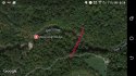
We know the girls were on the SE end of the bridge, and given the timeline, I'm confident that they were dropped off at the North end of the park. I don't believe that he would take a chance of being seen or meeting someone by forcing them to walk back to the North end of the High Bridge, but instead, as you say, he told them to go down the hill on the South end of the bridge.
Their bodies were found on the North side of the river, so it makes sense that they crossed the river at some point. I think it's very likely that the suspect murdered the girls near his vehicle. It makes complete sense that he parked at the cemetery after seeing the girls being dropped off, and saw the girls on the bridge. It might have been easiest to cross the river and enter the bridge from the SE end, turn around, then take the girls back the way he came - just South of the cemetery.

With all due respect, people might be misled by the images. The cell phone images LE released show the girls and BG at the SE or eastern end of the bridge, which is not in either of those images above.
I just don't want people to get confused.