You are amazing!Part 1/?
Apologies if this post gets too long, but I think this is important context. All of this is IMO/from my perspective as someone living in Eagan nearby where Bryce lived and went missing. The photos are mine and maps are screenshots from Google Maps. To make it easier to reference and discuss the photos, I have numbered them and marked on the map where they were taken.
Here we go:
I wanted to start by showing a map of all pertinent addresses from the night/early morning he went missing: where Bryce was dropped off at his friend's house, where his phone last pinged, and where he was trying to go. See Map 1 for these points plotted out.
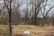
Around 11 am, we drove to the intersection of Highway 13 and Yankee Doodle, where there is a business office on one side of Highway 13 and a restaurant called Yankee Tavern on the other. News report on 11/4/22 by Tommy Wiita on Bring Me the News states that Bryce was "in a wooded area off Highway 13, the opposite direction to where he lived." Knowing this, we headed behind Yankee Tavern toward the Blue Cross Blue Shield campus, which is much larger than I thought. I had initially intended to start searching at the end of Yankee Doodle, which appeared to be a dead end on Google Maps. When we got there though, it turns out the public road ends there, and there isn't anywhere to park that isn't private property.
See photos 1-4. Although we did not stay and search here, I took a few photos. I don't recall where I saw (possibly on here?) someone reference the "BCBS Woods" - although there is a walking path with a wooded tree line area, I wouldn't necessarily call the area on BCBS property "woods". JMO. The more "heavily wooded" area is behind the businesses. Map 2 shows where these photos were taken.
See photo 4 - we did not enter the area marked "Valley Acres Police Range". If I had to guess, personally, this is where I think he ended up when he was on the phone at 2:34 am. It would have been the path of least resistance for someone who was intoxicated because it's a paved road.
We left this area in our vehicle and drove to the trailhead parking lot where we knew it would be okay to park, so we could walk the railroad tracks back toward BCBS. On the way, we encountered the Search and Rescue team. See photo 5.
To be continued in next post.

Install the app
How to install the app on iOS
Follow along with the video below to see how to install our site as a web app on your home screen.
Note: This feature may not be available in some browsers.
You are using an out of date browser. It may not display this or other websites correctly.
You should upgrade or use an alternative browser.
You should upgrade or use an alternative browser.
MN MN - Bryce Borca, 23, college student, seen at 2AM, search focused near Minnesota River, Eagan, 30 Oct 2022
- Thread starter GuyfromCanada
- Start date
Welcome to Websleuths!
Click to learn how to make a missing person's thread
Click to learn how to make a missing person's thread


Take my slow clap, and I'll throw in a long, slow whistle. I appreciate how you've organized your information! Thanks for being boots on the ground.Part 1/?
Apologies if this post gets too long, but I think this is important context. All of this is IMO/from my perspective as someone living in Eagan nearby where Bryce lived and went missing. The photos are mine and maps are screenshots from Google Maps. To make it easier to reference and discuss the photos, I have numbered them and marked on the map where they were taken.
Here we go:
I wanted to start by showing a map of all pertinent addresses from the night/early morning he went missing: where Bryce was dropped off at his friend's house, where his phone last pinged, and where he was trying to go. See Map 1 for these points plotted out.
Around 11 am, we drove to the intersection of Highway 13 and Yankee Doodle, where there is a business office on one side of Highway 13 and a restaurant called Yankee Tavern on the other. News report on 11/4/22 by Tommy Wiita on Bring Me the News states that Bryce was "in a wooded area off Highway 13, the opposite direction to where he lived." Knowing this, we headed behind Yankee Tavern toward the Blue Cross Blue Shield campus, which is much larger than I thought. I had initially intended to start searching at the end of Yankee Doodle, which appeared to be a dead end on Google Maps. When we got there though, it turns out the public road ends there, and there isn't anywhere to park that isn't private property.
See photos 1-4. Although we did not stay and search here, I took a few photos. I don't recall where I saw (possibly on here?) someone reference the "BCBS Woods" - although there is a walking path with a wooded tree line area, I wouldn't necessarily call the area on BCBS property "woods". JMO. The more "heavily wooded" area is behind the businesses. Map 2 shows where these photos were taken.
See photo 4 - we did not enter the area marked "Valley Acres Police Range". If I had to guess, personally, this is where I think he ended up when he was on the phone at 2:34 am. It would have been the path of least resistance for someone who was intoxicated because it's a paved road.
We left this area in our vehicle and drove to the trailhead parking lot where we knew it would be okay to park, so we could walk the railroad tracks back toward BCBS. On the way, we encountered the Search and Rescue team. See photo 5.
To be continued in next post.
InternetGhost91
Well-Known Member
- Joined
- Nov 10, 2022
- Messages
- 113
- Reaction score
- 824
Part 2/?
I want to correct something I posted earlier in this thread. I mistakenly said that the area in Eagan west of Highway 13 is all zoned for business, but I was incorrect. We observed at least 3-4 dwellings that appeared to be residential homes adjacent to Essendant where the Search and Rescue team was stationed. It was really odd because they are surrounded by very industrial businesses, and it isn't somewhere you would expect there to be homes. I'm guessing these are the kinds of places Eagan PD said they were canvassing on their FB page.
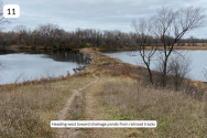
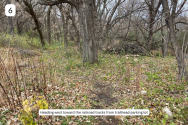
We parked at the trailhead and walked directly into the brush heading west toward the railroad tracks. See photo 6. I have walked the railroad tracks in the past to get photos, so I knew how dense the brush was here. You can tell the area has been cleaned out quite a bit by the parks department or whoever is in charge, there were piles of sticks and downed branches piled up and little paths in the grass, but there is no established trail here. This particular spot isn't where Bryce is believed to have entered, it's just where it was easiest for us to get in, but the terrain is similar all around this spot where the businesses end and the state park area begins.
We got to the railroad tracks and decided to walk south back toward where Yankee Doodle ends. It's very quiet back here, a deer crossed the railroad tracks behind us. We observed a few campsites along the tracks, likely used by homeless folks, one that appeared to be operational and another few that looked abandoned. I included a photo but did not mark on the map where I took it for privacy since this may be someone's home. I hope the Search and Rescue team has talked to anyone staying out there to see if they saw or heard anything when Bryce went missing.
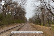
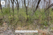
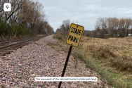
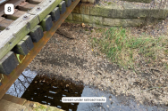
Photo 7 was taken walking along the tracks. Photo 8 shows a stream that runs under the tracks. It looks like a drainage situation, there were a lot of PVC pipes in the ground that bring water from up by the road down to the drainage pond/wetlands area. Photo 9 shows one of the state park signs indicating that land west of the railroad tracks is part of the nearby state park. Photo 10 shows what the sides of the railroad tracks look like for much of the portion that we walked.
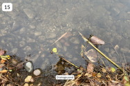
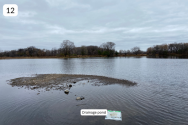
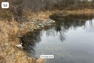
When we got to the drainage ponds, we left the tracks briefly. Photos 11-16 show one of the areas of interest: the drainage ponds. Several large drains let out into these ponds (lakes?). The water is not perfectly clear, but I was surprised how not muddy it was. There is considerable debris in the water - algae, aquatic plants, sediment. But it is not mud like I thought it would be.
I can only upload 10 photos per post. See post 3 for more.
I want to correct something I posted earlier in this thread. I mistakenly said that the area in Eagan west of Highway 13 is all zoned for business, but I was incorrect. We observed at least 3-4 dwellings that appeared to be residential homes adjacent to Essendant where the Search and Rescue team was stationed. It was really odd because they are surrounded by very industrial businesses, and it isn't somewhere you would expect there to be homes. I'm guessing these are the kinds of places Eagan PD said they were canvassing on their FB page.
We parked at the trailhead and walked directly into the brush heading west toward the railroad tracks. See photo 6. I have walked the railroad tracks in the past to get photos, so I knew how dense the brush was here. You can tell the area has been cleaned out quite a bit by the parks department or whoever is in charge, there were piles of sticks and downed branches piled up and little paths in the grass, but there is no established trail here. This particular spot isn't where Bryce is believed to have entered, it's just where it was easiest for us to get in, but the terrain is similar all around this spot where the businesses end and the state park area begins.
We got to the railroad tracks and decided to walk south back toward where Yankee Doodle ends. It's very quiet back here, a deer crossed the railroad tracks behind us. We observed a few campsites along the tracks, likely used by homeless folks, one that appeared to be operational and another few that looked abandoned. I included a photo but did not mark on the map where I took it for privacy since this may be someone's home. I hope the Search and Rescue team has talked to anyone staying out there to see if they saw or heard anything when Bryce went missing.
Photo 7 was taken walking along the tracks. Photo 8 shows a stream that runs under the tracks. It looks like a drainage situation, there were a lot of PVC pipes in the ground that bring water from up by the road down to the drainage pond/wetlands area. Photo 9 shows one of the state park signs indicating that land west of the railroad tracks is part of the nearby state park. Photo 10 shows what the sides of the railroad tracks look like for much of the portion that we walked.
When we got to the drainage ponds, we left the tracks briefly. Photos 11-16 show one of the areas of interest: the drainage ponds. Several large drains let out into these ponds (lakes?). The water is not perfectly clear, but I was surprised how not muddy it was. There is considerable debris in the water - algae, aquatic plants, sediment. But it is not mud like I thought it would be.
I can only upload 10 photos per post. See post 3 for more.
Attachments
-
 7. Walking along tracks.png625.6 KB · Views: 53
 -
 15. Drainage ponds.png490.5 KB · Views: 62
 -
 14. Drainage ponds.png545.6 KB · Views: 58
 -
 13. Drainage ponds.png464.7 KB · Views: 55
 -
 12. Drainage ponds.png342.8 KB · Views: 53
 -
 11. Drainage ponds.png496.3 KB · Views: 67
 -
 10. Heavy brush.png681.1 KB · Views: 55
 -
 9. State park.png578 KB · Views: 57
 -
 8. Stream.png638.3 KB · Views: 55
 -
 6. Headed west toward railroad tracks.png682.4 KB · Views: 70
Last edited:
InternetGhost91
Well-Known Member
- Joined
- Nov 10, 2022
- Messages
- 113
- Reaction score
- 824
3/?Part 2/?
I want to correct something I posted earlier in this thread. I mistakenly said that the area in Eagan west of Highway 13 is all zoned for business, but I was incorrect. We observed at least 3-4 dwellings that appeared to be residential homes adjacent to Essendant where the Search and Rescue team was stationed. It was really odd because they are surrounded by very industrial businesses, and it isn't somewhere you would expect there to be homes. I'm guessing these are the kinds of places Eagan PD said they were canvassing on their FB page.
We parked at the trailhead and walked directly into the brush heading west toward the railroad tracks. See photo 6. I have walked the railroad tracks in the past to get photos, so I knew how dense the brush was here. You can tell the area has been cleaned out quite a bit by the parks department or whoever is in charge, there were piles of sticks and downed branches piled up and little paths in the grass, but there is no established trail here. This particular spot isn't where Bryce is believed to have entered, it's just where it was easiest for us to get in, but the terrain is similar all around this spot where the businesses end and the state park area begins.
We got to the railroad tracks and decided to walk south back toward where Yankee Doodle ends. It's very quiet back here, a deer crossed the railroad tracks behind us. We observed a few campsites along the tracks, likely used by homeless folks, one that appeared to be operational and another few that looked abandoned. I included a photo (photo 8) but did not mark on the map where I took it for privacy since this may be someone's home. I hope the Search and Rescue team has talked to anyone staying out there to see if they saw or heard anything when Bryce went missing.
Photo 7 was taken walking along the tracks. Photo 8 shows a stream that runs under the tracks. It looks like a drainage situation, there were a lot of PVC pipes in the ground that bring water from up by the road down to the drainage pond/wetlands area. Photo 9 shows one of the state park signs indicating that land west of the railroad tracks is part of the nearby state park. Photo 10 shows what the sides of the railroad tracks look like for much of the portion that we walked.
When we got to the drainage ponds, we left the tracks briefly. Photos 11-16 show one of the areas of interest: the drainage ponds. Several large drains let out into these ponds (lakes?). The water is not perfectly clear, but I was surprised how not muddy it was. There is considerable debris in the water - algae, aquatic plants, sediment. But it is not mud like I thought it would be.
I can only upload 10 photos per post. See post 3 for more.
Map 3, Photo 16 and a picture of the aforementioned campsite.
Attachments

Gosh @InternetGhost91 - looks like so many possibilities for where he could have gone.  I hope he is found this weekend. Thank you for caring so much and for looking for him.
I hope he is found this weekend. Thank you for caring so much and for looking for him.InternetGhost91
Well-Known Member
- Joined
- Nov 10, 2022
- Messages
- 113
- Reaction score
- 824
4/4 - I will try to wrap everything up here along with my observations/thoughts, which again are my own opinion.
After having been in the area myself, I feel that it would have been extremely difficult for someone who was drunk to navigate this area in the dark. We didn't see a single light by the train tracks, so poor Bryce would have been out there in literal pitch darkness. It was hard for us to walk without tripping, and that's in the daylight, sober, and dressed for the weather.
I kept trying to put myself in his shoes, so to speak. I imagined that if I walked into a pond in the dark, I would think it was a puddle and probably continue trying to walk through it.
My partner who was out walking with me thinks Bryce met some kind of foul play with one of the transient folks in the area. My two cents - I can't think of a single time I have heard of someone being attacked by a homeless person in the twin cities. Am I wrong or being naive? I'm sure it has happened, but to me, this seems like the least likely scenario.
But... after nearly 2 weeks missing with hundreds of people searching the first couple of days, and search and rescue teams out still, you'd think someone would have found him. I'm honestly more confused about this case than ever. Where is he?
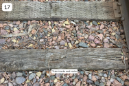
Does anyone know if these tracks are used? My partner told me they are decommissioned. I cannot recall whether I have ever seen a train on them. They are quite weathered and walking along them was not easy. The space between the tracks is filled with palm size rocks. See photo 17.
I want to clear up my questioning the Eagan PD in this thread earlier this week when they called off the volunteer searches - I think even for able-bodied folks, this area is difficult to walk through and they likely don't want anyone to sprain an ankle. It would be nearly impossible to get someone out of the state park/drainage pond area with a vehicle if they were seriously injured, and there are lots of places to slip/trip and fall. JMO but I think they are relying on professionals or people they are certain can traverse the terrain.
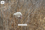
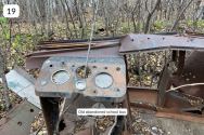
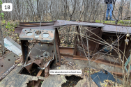
We encountered an old abandoned school bus in the state park area - included in photos 18-19. I also observed a piece of plastic in a tree near one of the drainage ponds that appeared to have a red stain on it, in photo 20. Blood maybe? It's a concerning thing to see, but we didn't see anything else around, just a lot of random trash.
Is there someone I should report the bloody cloth to? I didn't want to interact with the Search and Rescue team at all when I was out earlier. It looks like it's not really a cloth, it's like that plastic mesh material that tarps, animal food bags, etc are made of.
After having been in the area myself, I feel that it would have been extremely difficult for someone who was drunk to navigate this area in the dark. We didn't see a single light by the train tracks, so poor Bryce would have been out there in literal pitch darkness. It was hard for us to walk without tripping, and that's in the daylight, sober, and dressed for the weather.
I kept trying to put myself in his shoes, so to speak. I imagined that if I walked into a pond in the dark, I would think it was a puddle and probably continue trying to walk through it.
My partner who was out walking with me thinks Bryce met some kind of foul play with one of the transient folks in the area. My two cents - I can't think of a single time I have heard of someone being attacked by a homeless person in the twin cities. Am I wrong or being naive? I'm sure it has happened, but to me, this seems like the least likely scenario.
But... after nearly 2 weeks missing with hundreds of people searching the first couple of days, and search and rescue teams out still, you'd think someone would have found him. I'm honestly more confused about this case than ever. Where is he?
Does anyone know if these tracks are used? My partner told me they are decommissioned. I cannot recall whether I have ever seen a train on them. They are quite weathered and walking along them was not easy. The space between the tracks is filled with palm size rocks. See photo 17.
I want to clear up my questioning the Eagan PD in this thread earlier this week when they called off the volunteer searches - I think even for able-bodied folks, this area is difficult to walk through and they likely don't want anyone to sprain an ankle. It would be nearly impossible to get someone out of the state park/drainage pond area with a vehicle if they were seriously injured, and there are lots of places to slip/trip and fall. JMO but I think they are relying on professionals or people they are certain can traverse the terrain.
We encountered an old abandoned school bus in the state park area - included in photos 18-19. I also observed a piece of plastic in a tree near one of the drainage ponds that appeared to have a red stain on it, in photo 20. Blood maybe? It's a concerning thing to see, but we didn't see anything else around, just a lot of random trash.
Is there someone I should report the bloody cloth to? I didn't want to interact with the Search and Rescue team at all when I was out earlier. It looks like it's not really a cloth, it's like that plastic mesh material that tarps, animal food bags, etc are made of.
Attachments
Very interesting observations - thank you? Maybe just call the Eagen PD about the cloth?4/4 - I will try to wrap everything up here along with my observations/thoughts, which again are my own opinion.
After having been in the area myself, I feel that it would have been extremely difficult for someone who was drunk to navigate this area in the dark. We didn't see a single light by the train tracks, so poor Bryce would have been out there in literal pitch darkness. It was hard for us to walk without tripping, and that's in the daylight, sober, and dressed for the weather.
I kept trying to put myself in his shoes, so to speak. I imagined that if I walked into a pond in the dark, I would think it was a puddle and probably continue trying to walk through it.
My partner who was out walking with me thinks Bryce met some kind of foul play with one of the transient folks in the area. My two cents - I can't think of a single time I have heard of someone being attacked by a homeless person in the twin cities. Am I wrong or being naive? I'm sure it has happened, but to me, this seems like the least likely scenario.
But... after nearly 2 weeks missing with hundreds of people searching the first couple of days, and search and rescue teams out still, you'd think someone would have found him. I'm honestly more confused about this case than ever. Where is he?
Does anyone know if these tracks are used? My partner told me they are decommissioned. I cannot recall whether I have ever seen a train on them. They are quite weathered and walking along them was not easy. The space between the tracks is filled with palm size rocks. See photo 17.
I want to clear up my questioning the Eagan PD in this thread earlier this week when they called off the volunteer searches - I think even for able-bodied folks, this area is difficult to walk through and they likely don't want anyone to sprain an ankle. It would be nearly impossible to get someone out of the state park/drainage pond area with a vehicle if they were seriously injured, and there are lots of places to slip/trip and fall. JMO but I think they are relying on professionals or people they are certain can traverse the terrain.
We encountered an old abandoned school bus in the state park area - included in photos 18-19. I also observed a piece of plastic in a tree near one of the drainage ponds that appeared to have a red stain on it, in photo 20. Blood maybe? It's a concerning thing to see, but we didn't see anything else around, just a lot of random trash.
Is there someone I should report the bloody cloth to? I didn't want to interact with the Search and Rescue team at all when I was out earlier. It looks like it's not really a cloth, it's like that plastic mesh material that tarps, animal food bags, etc are made of.
I also went to search today. Parked at the dead end of Yankee across 13 in the BCBC parking lot. Went down a paved path on the right and crossed through a small wooded area and landed at the RR tracks. I was not far to the left of where Bryce’s phone went dead and he headed back into that area. Followed the tracks right behind all the industrial buildings to the ponds. Also saw the search and rescue station and ran into many searchers along the way. Saw the few houses too. Did not see the homeless encampment, but knew there was one nearby. None of the wooded areas by the tracks seemed heavily wooded…just a strip of trees you could easily walk through. Noticed many of the industria lots and buildings had lights on them or in the lots. Not sure if they would have been on at 3am on a Sat night. Walked the tracks and almost stumbled multiple times in daylight. Hard to believe he did not fall while drunk if he followed those. I detoured into the weeds and brush at various points. Tough to get through without tripping…again in daylight and sober. Don’t see him making it too far back into that. When I got to the ponds, a few were very shallow. Searchers should see or find him in those. The 2 large ones have a strip of land/path between him. Both seemed to have mostly shallow shoreline where he would be found and not sink way into the deep middle water. I still don’t see him wondering in the dark around those and not falling in a shallow spot first. Again I would think he could be found in those. LE has had both boats and divers there multiple times though. I saw no one searching in the water today, but a few search groups with K9 dogs. Don’t know if they were LE or private.
Anyone know if the moon was full that night? Wondering if it was totally dark or if had some light on his walk?
Internetghost91, do you know if the search station they have set up, is for the public to check in at or ask questions about the best places to search? It seems with nothing organized for the public, we are just searching the same areas over and over, and could be so much more effective if this were organized.
acutename
Well-Known Member
- Joined
- Jan 18, 2019
- Messages
- 3,844
- Reaction score
- 26,998
Is there a video about drunken lost person behavior?
Not sure why bodies are not found in water when they are searched w/ sonar but I know Taleka Patrick (was on WS) was found by a fisherman the next spring (I think) and a jogger, David Burd, was found by people canoeing the next spring. I think LE is probably concerned that if there is a sink hole or a bad spot, they do not want to have to rescue more people, IMO.
Not sure why bodies are not found in water when they are searched w/ sonar but I know Taleka Patrick (was on WS) was found by a fisherman the next spring (I think) and a jogger, David Burd, was found by people canoeing the next spring. I think LE is probably concerned that if there is a sink hole or a bad spot, they do not want to have to rescue more people, IMO.
InternetGhost91
Well-Known Member
- Joined
- Nov 10, 2022
- Messages
- 113
- Reaction score
- 824
I did not want to interact with LE so I didn't approach to ask. I am going back out tomorrow with a friend and if they are still out there, I will ask.I also went to search today. Parked at the dead end of Yankee across 13 in the BCBC parking lot. Went down a paved path on the right and crossed through a small wooded area and landed at the RR tracks. I was not far to the left of where Bryce’s phone went dead and he headed back into that area. Followed the tracks right behind all the industrial buildings to the ponds. Also saw the search and rescue station and ran into many searchers along the way. Saw the few houses too. Did not see the homeless encampment, but knew there was one nearby. None of the wooded areas by the tracks seemed heavily wooded…just a strip of trees you could easily walk through. Noticed many of the industria lots and buildings had lights on them or in the lots. Not sure if they would have been on at 3am on a Sat night. Walked the tracks and almost stumbled multiple times in daylight. Hard to believe he did not fall while drunk if he followed those. I detoured into the weeds and brush at various points. Tough to get through without tripping…again in daylight and sober. Don’t see him making it too far back into that. When I got to the ponds, a few were very shallow. Searchers should see or find him in those. The 2 large ones have a strip of land/path between him. Both seemed to have mostly shallow shoreline where he would be found and not sink way into the deep middle water. I still don’t see him wondering in the dark around those and not falling in a shallow spot first. Again I would think he could be found in those. LE has had both boats and divers there multiple times though. I saw no one searching in the water today, but a few search groups with K9 dogs. Don’t know if they were LE or private.
Anyone know if the moon was full that night? Wondering if it was totally dark or if had some light on his walk?
Internetghost91, do you know if the search station they have set up, is for the public to check in at or ask questions about the best places to search? It seems with nothing organized for the public, we are just searching the same areas over and over, and could be so much more effective if this were organized.
I agree with you about feeling like we are searching the same areas over and over. I go back and forth with thinking that's a good thing, or a waste of time. Sometimes people are found in areas that were already searched numerous times. I guess I would rather have a spot searched more than once vs. not at all, but you're right that it is potentially ineffective.
JMO, but I feel very sure Bryce is in the woods near the search area still. It would have been really difficult for him to get out of the wooded area once he was in there. If he made it west of the train tracks, I could see someone going in circles trying to get back out in the dark. That said, it's also puzzling why no one has found him because I don't think he would have gotten very far.
I also did not observe anyone searching the water. I saw no boats or divers.
I also wonder if he saw lights of Bloomington like the HealthPartners building and airport and tried to head that way, but again would have had to go through that horrible terrain. I could see those buildings though from the RR tracks and could see and hear the planes and freeway(494), but not sure what one can see or hear at 3am.I did not want to interact with LE so I didn't approach to ask. I am going back out tomorrow with a friend and if they are still out there, I will ask.
I agree with you about feeling like we are searching the same areas over and over. I go back and forth with thinking that's a good thing, or a waste of time. Sometimes people are found in areas that were already searched numerous times. I guess I would rather have a spot searched more than once vs. not at all, but you're right that it is potentially ineffective.
JMO, but I feel very sure Bryce is in the woods near the search area still. It would have been really difficult for him to get out of the wooded area once he was in there. If he made it west of the train tracks, I could see someone going in circles trying to get back out in the dark. That said, it's also puzzling why no one has found him because I don't think he would have gotten very far.
I also did not observe anyone searching the water. I saw no boats or divers.
IMO and from walking back there today, I think if he is not in the ponds, he is not far back from the industrial area or found his way back to a road.
InternetGhost91
Well-Known Member
- Joined
- Nov 10, 2022
- Messages
- 113
- Reaction score
- 824
My partner also suggested when we were out earlier that he may have been trying to go toward the airport since it would have been lit up at night. IMO I thought it would be more likely that he would try to go back the way he came. Agree with you that I don't think he made it far.I also wonder if he saw lights of Bloomington like the HealthPartners building and airport and tried to head that way, but again would have had to go through that horrible terrain. I could see those buildings though from the RR tracks and could see and hear the planes and freeway(494), but not sure what one can see or hear at 3am.
I'm out of things to say about this for now, but I will report back tomorrow when I'm able to go out again. I'm disappointed, I thought going to search the area in person would make things more clear but it just raises more questions for me.
Last edited:
acutename
Well-Known Member
- Joined
- Jan 18, 2019
- Messages
- 3,844
- Reaction score
- 26,998
1. could he be hidden by fallen or falling leaves?I did not want to interact with LE so I didn't approach to ask. I am going back out tomorrow with a friend and if they are still out there, I will ask.
I agree with you about feeling like we are searching the same areas over and over. I go back and forth with thinking that's a good thing, or a waste of time. Sometimes people are found in areas that were already searched numerous times. I guess I would rather have a spot searched more than once vs. not at all, but you're right that it is potentially ineffective.
JMO, but I feel very sure Bryce is in the woods near the search area still. It would have been really difficult for him to get out of the wooded area once he was in there. If he made it west of the train tracks, I could see someone going in circles trying to get back out in the dark. That said, it's also puzzling why no one has found him because I don't think he would have gotten very far.
I also did not observe anyone searching the water. I saw no boats or divers.
2. did he have anything with him except the phone that
anyone might have taken and tried to sell or pawn?
3. LE found his tie (possibly)- where was that? near where he made
the phone call?
imagine dogs would find him if he was not in water
I also think of all the wasted days, that so many people were asking and offering to go out there and search, and no response from LE or family/friends. We could have covered so much ground and maybe found him by now. Like the Joe Brunn search year years ago. Disappointing.
ifindedout
Well-Known Member
- Joined
- Aug 29, 2022
- Messages
- 3,789
- Reaction score
- 16,914
RSBMDoes anyone know if these tracks are used? My partner told me they are decommissioned. I cannot recall whether I have ever seen a train on them. They are quite weathered and walking along them was not easy. The space between the tracks is filled with palm size rocks. See photo 17.
This is Union Pacific's Mankato Subdivision. Mankato Subdivision
Not decommissioned at all, shiny rails are a sure indicator that the tracks are active. The pieces of stone are typical railroad ballast, the color depends upon the quarry it is sourced from (the pink rocks are granite from a quarry in Wisconsin).
InternetGhost91
Well-Known Member
- Joined
- Nov 10, 2022
- Messages
- 113
- Reaction score
- 824
I hope they decide to call back volunteers before significant snowfall.I also think of all the wasted days, that so many people were asking and offering to go out there and search, and no response from LE or family/friends. We could have covered so much ground and maybe found him by now. Like the Joe Brunn search year years ago. Disappointing.
UltraViolet4545
Well-Known Member
- Joined
- Feb 26, 2018
- Messages
- 217
- Reaction score
- 2,089
We saw a train going by one day (not sure which day, but within the past week while searching) so they are definitely active tracks.
Thanks for heading out there and getting such good photos and searching (both of you posters above)! I don’t know if there is a way to do it on here, but perhaps a map of the area could be somehow added to this thread and posters could put an X on an area once they have searched it? Like a running list of places searched? Just spitballing here…
IMO, a place I want to search next is just past the holding ponds, heading towards gun club lake. That wooded section.
InternetGhost91
Well-Known Member
- Joined
- Nov 10, 2022
- Messages
- 113
- Reaction score
- 824
We saw a train going by one day (not sure which day, but within the past week while searching) so they are definitely active tracks.
Thanks for heading out there and getting such good photos and searching (both of you posters above)! I don’t know if there is a way to do it on here, but perhaps a map of the area could be somehow added to this thread and posters could put an X on an area once they have searched it? Like a running list of places searched? Just spitballing here…
IMO, a place I want to search next is just past the holding ponds, heading towards gun club lake. That wooded section.
thanks for confirming. a map would be a great idea, i saw someone in another thread make one on google maps that was interactive. i can try to figure out how.We saw a train going by one day (not sure which day, but within the past week while searching) so they are definitely active tracks.
Thanks for heading out there and getting such good photos and searching (both of you posters above)! I don’t know if there is a way to do it on here, but perhaps a map of the area could be somehow added to this thread and posters could put an X on an area once they have searched it? Like a running list of places searched? Just spitballing here…
IMO, a place I want to search next is just past the holding ponds, heading towards gun club lake. That wooded section.
I keep trying to figure out the chances he made it past the ponds vs getting hung up in the brush before reaching them.
UltraViolet4545
Well-Known Member
- Joined
- Feb 26, 2018
- Messages
- 217
- Reaction score
- 2,089
thanks for confirming. a map would be a great idea, i saw someone in another thread make one on google maps that was interactive. i can try to figure out how.
I keep trying to figure out the chances he made it past the ponds vs getting hung up in the brush before reaching them.
Yes, I totally agree. I think there is a strong chance he’s in those ponds. They would be so easy to to fall into out there in the dark— they’re right there.
But… since I can’t search the ponds, I kinda fall back on “well, what can I search?” And then I think well… he could also be out in those woods. So I might as well search there since he’s still not found. Hopefully my line of thought makes sense ha, typing fast on my way to a dinner event.
Thank you for your post and for all your hard work for Bryce!I also went to search today. Parked at the dead end of Yankee across 13 in the BCBC parking lot. Went down a paved path on the right and crossed through a small wooded area and landed at the RR tracks. I was not far to the left of where Bryce’s phone went dead and he headed back into that area. Followed the tracks right behind all the industrial buildings to the ponds. Also saw the search and rescue station and ran into many searchers along the way. Saw the few houses too. Did not see the homeless encampment, but knew there was one nearby. None of the wooded areas by the tracks seemed heavily wooded…just a strip of trees you could easily walk through. Noticed many of the industria lots and buildings had lights on them or in the lots. Not sure if they would have been on at 3am on a Sat night. Walked the tracks and almost stumbled multiple times in daylight. Hard to believe he did not fall while drunk if he followed those. I detoured into the weeds and brush at various points. Tough to get through without tripping…again in daylight and sober. Don’t see him making it too far back into that. When I got to the ponds, a few were very shallow. Searchers should see or find him in those. The 2 large ones have a strip of land/path between him. Both seemed to have mostly shallow shoreline where he would be found and not sink way into the deep middle water. I still don’t see him wondering in the dark around those and not falling in a shallow spot first. Again I would think he could be found in those. LE has had both boats and divers there multiple times though. I saw no one searching in the water today, but a few search groups with K9 dogs. Don’t know if they were LE or private.
Anyone know if the moon was full that night? Wondering if it was totally dark or if had some light on his walk?
Internetghost91, do you know if the search station they have set up, is for the public to check in at or ask questions about the best places to search? It seems with nothing organized for the public, we are just searching the same areas over and over, and could be so much more effective if this were organized.
DNASolves
Online statistics
- Members online
- 102
- Guests online
- 1,573
- Total visitors
- 1,675
Totals may include hidden visitors.