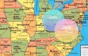
Switching away from DNA briefly, I'm still interested in exactly where the crime took place on Locklair Road. Last night I watched a YouTube video that had some information I'd never heard before. This guy referenced several articles from the Greenville News during the immediate aftermath. He said that the murders were actually several hundred yards away from the Locklair intersection, and not nearby.
The summary from law enforcement is that the killer drove several hundred yards down Locklair and apparently intended to commit the murders in a densely tree covered area further toward the center of Locklair, but was prevented from doing so by tall fences that blocked the road. So he forced the couple out and committed the murders right there at the side of the road. Then he used the pathway of a nearby tobacco hut to pull in and then back out, before speeding away.
I appreciate how much research this guy did. It makes sense because it seemed obvious to me when I visited Locklair last year that the topography had changed significantly since 1976. It didn't make sense for so many tall healthy pine trees to be in the center of Locklair on both sides, and nowhere else. The newspaper photo from 1976 clearly shows pine trees on both sides of Locklair.
Based on that video info I now believe the murders occurred in the area of this photo that is now wide open farmland, maybe just prior to where the dirt looks much darker. That would fit with the 400m estimate to I-95 from another recent video.
Imgur: The magic of the Internet
Then over time the pine trees, tobacco stand and fencing were removed toward a farmland attempt that has not been overly successful, from the look of things.
This is the video with the info on the site of the murders, specifically from the 8 minute mark to the 9 minute mark. There is other good material as well, including a photo of the caskets being exhumed for DNA testing: