By the way, I have made a few maps in case anyone else is as confused as I am about street names and distances. If the images are too big let me know and I'll swap them with links.
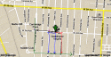
This first map shows the area where Lola was last seen. The pink spot marks the area where she lived, on West 3rd Avenue between Glenn and Westwood. The orange trail/spot is how much she would have walked to take the bus at Cambridge Boulevard and West 3rd Avenue. It's not a huge distance but it strikes me as peculiar, why would she walk such a long way when she could have taken what was reportedly the same bus (according to the man who lived nearby; so it's not the bus she disliked which included a transfer elsewhere).
The other spots all mark different places where her neighbor has been reported to have gotten on the bus.
If I understood it correctly (see nerosleuth's and my own posts above) if he walked to Glenn Avenue and West 3rd Avenue (the light blue spot) he would have walked past her house. If she loved on the other side of the block then this applies to Westwood Avenue and West 3rd Avenue (the light purple spot). Either way, in one of these he walks past her house, in the other he does not. One of them would have been closer to his house than hers.
The green spot is the area at the intersection of Westwood and West 1st, which is where some reports place him when he boarded the bus. As you can see, that would definitely entail a rather long walk. However, if he took a while to get ready and the bus followed that route then he could have ran there instead of taking it at Cambridge. If the bus stop was empty (because Lola wasn't there) and if he could see him from his doorstep then he could have thought the bus had left already and decided to sprint down.
The biggest questions here IMO are - what was the bus's actual route? IF it didn't go from Cambridge and then south and east to the Westwood/1st Intersection, then there would have been places closer to home where Lola and possibly her neighbour also could have taken it. Unless he saw her after she walked past Glenn Avenue, how could he have guessed that she was going all the way to the Cambridge stop? Was she planning on taking a detour? I think that knowing where the bus would actually stop and that specific one (plus the one that had a transfer and which Lola disliked, because maybe that one was the one the neighbor boarded and that's why she wasn't there - but surely police would have put two and two together and crossed that out so I don't think this is likely) would be really helpful. Does anyone know where we could find this information?

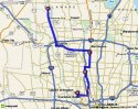
Please ignore the purple thing on this map, I was just feeling too lazy to come up with a blank and make my own markings on it on Paint. Point A is the West 3rd Avenue area (I'm not marking any specific intersections) and Point B is the
East Gay Street and North High Street intersection where she was going to buy nylons. We don't know where the bus stopped and if she would have headed there directly, this is just for reference.
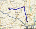
This map shows the distance between the West 3rd area and Olentangy River Road area where the shoe being thrown out of the car was reported.
Please ignore the purple track, again. The orange thing followed by the purple track, which I believe is a freeway, may be misleading. I don't know if it would have existed in Lola's time but either way, the road you're looking for has a similar name but it's not the freeway. Look a bit east where it says "315", it's there between the freeway and the river. Near the spot where it says "Ohio State University", and then a bit further south next to West 5th Avenue, you can see that both seem to sort of overlap, which makes the map looking confusing. The roads stretch north, too. If you can I would advise everyone to go look at it on Google Maps because it's easier.
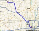
This map shows the area
where a school girl was attacked by a man a few days after Lola's disappearance, vs. West 3rd Avenue. The place where the attack happened is in green. West 3rd Avenue is marked in pink. You can see the block between Glenn and Westwood close to the border of the map. If you look at the first map, you can see that unseen here but after Glenn it would be Wyandotte, Lincoln, and Cambridge.
I also wanted to add two things that I was thinking about while making these:
- There's yet another report
here about what the neighbor saw. In this after he goes out he sees her down the road but presumably doesn't call her. So we have basically three different scenarios - one, he's inside his house and sees her but says nothing and doesn't see her when he goes out, two, he's inside the house and sees her but says nothing and when he goes out he sees her again, and three, he sees her while he's inside and calls out after her.
- Another report says she worked at Bokes Creek Township Rural School which is also in Logan County - but it's not the same as West Mansfield High School, is it? So which one did she teach at after all?
- Finally, I was thinking about the Catholic church (you can see the map
here, it's the one called Our Lady of Victory not First Community Church) which nerosleuth had mentioned. I Googled it to find out if it would have been there in Lola's day and yes - it was founded in 1922. More information about its history plus a picture
here.
As an aside, I'm sorry for the light colours and weird markers on the maps above. I wanted to keep the tracks/spots more or less transparent without using Photoshop so I used one of the more transparent brushes on paint and used lighter colours so the text with the street names underneath it would be more easily readable.


") I think she would have walked past his house if he lived closer to the Glenn street side than she did. I believe that's what nerosleuth was saying a couple of posts above this one, that if he caught the bus on Westwood he would have walked past her house.
I think she would have walked past his house if he lived closer to the Glenn street side than she did. I believe that's what nerosleuth was saying a couple of posts above this one, that if he caught the bus on Westwood he would have walked past her house.