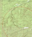
For another view of the terrain in the area where the Jamison family became lost I have added a topographical map. I heard recent reports that the skeletons were found 2.7 miles north/northwest of the abandoned truck so I placed a range ring on the map with a radius of 2.7 miles and centered the ring on the truck.
One of the most valuable features of a topo map are the contour lines. These are the squiggly lines covering the map which indicate the slope of the areas of the map. The distance between two parallel contour lines on the map corresponds to a 20' change in elevation making it easy to visualize steepness. Lines that are close together represent steep terrain, and flat terrain will be indicated by large spaces between the contour lines.
The map feature called Smokestack Hollow is a channel or valley beginning at a point about ½ mile southwest of the truck progressing generally north in a clockwise direction where it crosses the 2.7 mile ring at a point between 11 and 12 O'clock on the ring. It doesn't seem likely to me that the Jamison family would have walked across Smokestack Hollow because the terrain is extremely steep. The most likely route that would take them to a point 2.7 aerial miles north or northwest of their truck without crossing the Hollow would seem to be the trail or road that I depicted as a black line. They would have walked south from their truck about ½ mile then taken off west while generally following the ridge running parallel to Smokestack Hollow in a northward direction. They would have reached the 2.7 mile mark at a point north of their truck. They might have crossed the 2.7 mile ring between 11 and 12 O'clock and then turned back southwest and found their way to the feature labeled Gas Well at an elevation of 763'. I'm only speculating that the skeletons were found somewhere near the road and range ring so if anyone here has obtained the actual coordinates, just let me know and I'll update my map.
Because topography does not change much with time these topo maps are not often updated. The included map was probably last updated in the late 70s or early 80s. Although the topo depicts a number of roads (double dotted lines) and trails (single dotted line), many roads that can be seen on current satellite photos are not visible on the topo. Neither the well location where their truck was abandoned or much of the trail/road that they may have taken is visible on the original topo because they did not exist when the map was made. I obtained additional trail/road information from satellite photos and placed it on the topo.
The topo illustrates pretty well that the terrain is challenging in some areas. The final ¼ mile of the trail before reaching the 2.7 mile mark changes in elevation by about 200' which is steep but certainly not impassible, and portions of the sides of Smokestack Hollow are almost vertical. However, as rough as the terrain is, it is difficult for me to understand how two adults could have been unable to find their way back to the truck or obtain help. There are many more gas wells in the area than are depicted on the topo, and lease operators regularly drive on the lease roads in the area to check on these wells. The difficulty of navigating the terrain by walking on roads should not have been an excessive challenge unlike the difficulty the searchers encountered after leaving the roadways to search for the Jamisons in the woods.
If Mr. Jamison was familiar enough with a gps and land navigation in general to find the tract of land that the truck was near, he should have been able to find his way back to the truck along the trail even without a gps. Maybe he left the gps in the truck because he had already found the tract of land and the gps wouldn't be necessary for a simple walk along the road or trail. It is puzzling that they left their dog in the truck while they went for a hike unless the dog was one of those that tends to run off, or maybe they left it in the truck to keep people out of the truck and away from the cash. They put a significant amount of effort into organizing their outing and finding the location of a tract of land in the mountains which suggests to me that they didn't initially have a mutual pact to drive into the woods and commit suicide. It is beginning to look like they decided to take a hike but at some point became unable to think clearly enough to find their way back or obtain help, or some other misfortune befell them. Whatever happened is certainly a tragedy, especially for the little girl who depended on her parents to make good decisions on her behalf.


