OK OK - Jamison Family; Truck, IDs and Dog Found Abandoned, 8 Oct 2009 - #11

DNA Solves
DNA Solves
DNA Solves
Status
Not open for further replies.
So let me get this straight -- they think they found the bodies but yet the brown briefcase that held either drugs or money or something else and the gun was never found? Oh and his set of keys. And now I'm wondering if his wallet was ever found? So if all of these things are missing, they either dumped them someplace beforehand, which would make no sense since they left basically everything else important in the truck or someone got ahold of those things.

This case has always been on my mind since the first I heard of it. I just didn't stay caught up with it.
 
After 3 1/2 years of following this case, I finally was able to get a username (for some reason the site doesn't like my email address). As an Oklahoman, this family is what led me to Websleuths and I have been following a couple other cases since. My heart truly breaks for this family, and as a mom, I can't think of anything worse than to see your child perish in any way. Thanks a million times over again for all mtrooper and the rest of you have done. The amount of hours and sleepless nights that has gone into this case is amazing and humbling.
 
I do not know how to enlarge it any more without distorting it. As it was I had to use the map and then veiw the image though the galaxy 3 ,which also produced better results then the Iphone .


I was able to make out a reddish color (clothing I think ) and it appears there is a brown colored jacket and I want to say that there seems to be some sort of print of applicate on something. (hoodie with a printed logo kinda thing maybe?)

I can only make out 2 set of remains.

https://maps.google.com/maps?q=35.0509524338,+-95.1977539863&ie=UTF-8&hq=&hnear=0x87b579b66cec5d39:0x6deb4a8d9df4076c,35.0509524338,+-95.1977539863&gl=us&ei=KWuNUpS3I4TqkQffzoDIBA&ved=0CC4Q8gEwAA Type the cords onto this map.

I can only zoom in so far. I can't see much. Now I'm curious!! Want to see more!!

Awesome repeat posts!!! Thank you!
 
Regarding the call from Bobby's phone on the 12th... IIRC, in the days after 9/11, many family members received VMs from their loved ones, leading them to believe they were still alive. Could a delayed mix up have happened here, with such the spotty signal?

Also, I would like to know how the FBI cleared the roommate (or whatever you want to call him, handyman, friend). Was it solely alibi? Because it sounds like he's had a few run ins with Sherilyn and those are just the ones we know about.
 
I can only zoom in so far. I can't see much. Now I'm curious!! Want to see more!!

Awesome repeat posts!!! Thank you!

I tried Bing Maps, but can't see a thing. Their image was taken during a warm season and there's too much tree cover. Sometimes when you zoom in on Bing, the view switches to a different season, like maybe autumn, but not in this case.

Also tried Historic Aerials, but their most recent photo of the area is from 2003.

So annoying that Oklahoma LE is so tight-lipped about evidence and I'm starting to think maybe that's one reason so many cases go unsolved here. There's no news coverage if there's nothing new to report, and people's attention drifts elsewhere. Until remains are found, then there's a brief flurry of attention again, and then... nothing. If they'd dribble out little bits of information from time to time, it would help keep people aware of the case and maybe jog someone's memory, while cutting down on the wild speculation that fills the void left by the absence of accurate info.

They've had a week now to examine the scene, so I really wish someone would give us the exact location. This potential body that Soulmagent has found, I tend to think it's not one of the Jamisons strictly due to what little we do know of the location, since it appears to be more to the west along Smokestack Hollow, but that doesn't rule out the possibility of it being someone else's remains that somehow wound up at that place shortly before March 11, 2012. If I lived in the area, I'd be tempted to drive up there just to take a look at that spot.
 
I do not know how to enlarge it any more without distorting it. As it was I had to use the map and then veiw the image though the galaxy 3 ,which also produced better results then the Iphone .

I was able to make out a reddish color (clothing I think ) and it appears there is a brown colored jacket and I want to say that there seems to be some sort of print of applicate on something. (hoodie with a printed logo kinda thing maybe?)

I can only make out 2 set of remains.

Difficult.. it does look like it could be two people lying together or it could be stones/logs. Think you've got a better zoom than me.

Just wondering, is it worth contacting the LE involved and passing this on? If it is the family, and the photo is from several months ago it might help the coroner?
 
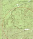
For another view of the terrain in the area where the Jamison family became lost I have added a topographical map. I heard recent reports that the skeletons were found 2.7 miles north/northwest of the abandoned truck so I placed a range ring on the map with a radius of 2.7 miles and centered the ring on the truck.

One of the most valuable features of a topo map are the contour lines. These are the squiggly lines covering the map which indicate the slope of the areas of the map. The distance between two parallel contour lines on the map corresponds to a 20' change in elevation making it easy to visualize steepness. Lines that are close together represent steep terrain, and flat terrain will be indicated by large spaces between the contour lines.

The map feature called “Smokestack Hollow” is a channel or valley beginning at a point about ½ mile southwest of the truck progressing generally north in a clockwise direction where it crosses the 2.7 mile ring at a point between 11 and 12 O'clock on the ring. It doesn't seem likely to me that the Jamison family would have walked across Smokestack Hollow because the terrain is extremely steep. The most likely route that would take them to a point 2.7 aerial miles north or northwest of their truck without crossing the Hollow would seem to be the trail or road that I depicted as a black line. They would have walked south from their truck about ½ mile then taken off west while generally following the ridge running parallel to Smokestack Hollow in a northward direction. They would have reached the 2.7 mile mark at a point north of their truck. They might have crossed the 2.7 mile ring between 11 and 12 O'clock and then turned back southwest and found their way to the feature labeled “Gas Well” at an elevation of 763'. I'm only speculating that the skeletons were found somewhere near the road and range ring so if anyone here has obtained the actual coordinates, just let me know and I'll update my map.

Because topography does not change much with time these topo maps are not often updated. The included map was probably last updated in the late 70s or early 80s. Although the topo depicts a number of roads (double dotted lines) and trails (single dotted line), many roads that can be seen on current satellite photos are not visible on the topo. Neither the well location where their truck was abandoned or much of the trail/road that they may have taken is visible on the original topo because they did not exist when the map was made. I obtained additional trail/road information from satellite photos and placed it on the topo.

The topo illustrates pretty well that the terrain is challenging in some areas. The final ¼ mile of the trail before reaching the 2.7 mile mark changes in elevation by about 200' which is steep but certainly not impassible, and portions of the sides of Smokestack Hollow are almost vertical. However, as rough as the terrain is, it is difficult for me to understand how two adults could have been unable to find their way back to the truck or obtain help. There are many more gas wells in the area than are depicted on the topo, and lease operators regularly drive on the lease roads in the area to check on these wells. The difficulty of navigating the terrain by walking on roads should not have been an excessive challenge unlike the difficulty the searchers encountered after leaving the roadways to search for the Jamisons in the woods.

If Mr. Jamison was familiar enough with a gps and land navigation in general to find the tract of land that the truck was near, he should have been able to find his way back to the truck along the trail even without a gps. Maybe he left the gps in the truck because he had already found the tract of land and the gps wouldn't be necessary for a simple walk along the road or trail. It is puzzling that they left their dog in the truck while they went for a hike unless the dog was one of those that tends to run off, or maybe they left it in the truck to keep people out of the truck and away from the cash. They put a significant amount of effort into organizing their outing and finding the location of a tract of land in the mountains which suggests to me that they didn't initially have a mutual pact to drive into the woods and commit suicide. It is beginning to look like they decided to take a hike but at some point became unable to think clearly enough to find their way back or obtain help, or some other misfortune befell them. Whatever happened is certainly a tragedy, especially for the little girl who depended on her parents to make good decisions on her behalf.
 

Attachments

  • Jamison.jpg
    Jamison.jpg
    155.1 KB · Views: 94
If I lived in the area, I'd be tempted to drive up there just to take a look at that spot.

I have no idea if I'm quoting right, it's my first time to try, but anyway....
Honestly, I've had that thought a time or two over the years. It's only like a 3 hour drive.
 
Excellent first post Mapman! Very insightful and helpful. Thank you!

Say, would you be able to put a marker in your map for the spot Soulmagent identified on the previous page? Where it looks like possibly two bodies are lying there?

Or if not, would you be able to tell if this spot is on a slope, or close to the black path you indicated?
 
Dallen, first welcome, and thank you for an excellent post.

Second, the map was interesting. One thing that it showed is once someone is just above the area of the well site, it was down hill, or level, to the area were the body was found.
 
Thanks OkieGranny for bringing that video back up. It had been so long since I've seen it, I forgot how in the middle of nowhere it was. That being said, I'm not sure why someone would feel the need to place the bodies 2.7 miles from where the truck was found (or force them to hike that far before killing them). It would have taken LE or searchers long enough to discover the bodies anywhere near the truck.
 
Speaking of videos, could someone please link me to the surveillance video from the Jamison home? People keep saying they looked so dazed, and I read in one article that it looked like a third person was there. I have been googling but can not find it. Thank you!
 
Elainera - The attached map depicts an area around the location of the two sets of coordinates that Soul referred to. They are small yellow labels 1 & 2. You might notice that individuals sections of land are shown with dotted red lines for borders. Each of these squares is 1 mile by 1 mile. As you can see, the coordinates that Soul found are near the center of section 28. These two points are about 1/2 mile beyond the 2.7 mile ring which means that they are about 3.2 miles from the truck. It is possible that the 2.7 mile number reported by law enforcement is not precise, but I would have expected it to be closer.

I also included on the map the coordinates for the points where the road/trail intersects the 2.7 mile range ring at the two different locations.
 

Attachments

  • Jamison2.jpg
    Jamison2.jpg
    268.8 KB · Views: 48
When I joined this forum it was for this case because I had a dream I believed involved them. I was looking at the google maps view of the location they were found and something stood out to me. There's a house with a green roof near a large pond at the end of a driveway. This house looks just like the dream I had. There's a vehicle in the back of the house I remember walking by in the dream. In the dream I was seeing things from Sherilyn's point of view I'm sure. We walked to this house, past the white vehicle, over a porch or patio under tree cover, and into the house. There were other people there.

At one point I was looking through a closet and the little girl was nearby. I had a tube of something, like toothpaste or glue maybe. In the closet there was some kind of bottle with the name “Elizabeth” written on it. I hear a woman coming into the room, startle, and step out of the closet leaving the tube in there.

We had a conversation about cats being killed and I think the woman was making fun of me or laughing because I was upset over the cats being killed. Words got angry and I remember the phrase "three river killer" being said. The end of the dream gets fuzzy but I distinctly remember the feeling of the roof of my mouth being cut with something, possibly a pizza cutter or rotary scissors, then I woke up and the roof of my mouth still hurt for a few minutes.

I know this is weird and maybe not forum-appropriate, but it's worth noting I have had dreams and visions that panned out before.
 
I have no idea if I'm quoting right, it's my first time to try, but anyway....
Honestly, I've had that thought a time or two over the years. It's only like a 3 hour drive.

Yeah, about that far for me, too. I'd have to borrow a heavy-duty truck if I went. Don't think my trusty little Zipmobile could handle those roads, and it's not a place I'd want to be stranded...
 
Status
Not open for further replies.

Members online

Online statistics

Members online
250
Guests online
2,639
Total visitors
2,889

Forum statistics

Threads
599,632
Messages
18,097,621
Members
230,893
Latest member
Moonlit7
Back
Top