@Saphyrrra
I literally just signed up, but I've been following this blog since the story broke and would like to commend its integrity. I made a PDF screenshot of the circle and timeline because the logistics were driving me nuts. For background, I'm from Lancaster and recently moved back last year. I was raised in another Amish area, but worked at the Steamboat Inn and another hotel in the Bird-in-Hand area for 7 years, and have a deep connection to the very kind community there. I'm a bit of a shady character myself (but with a kind heart) and I am extremely familiar with those roads from smoke breaks at work. This is why the map drives me nuts, it makes no logistical sense. I also agree with other posts that I would love to be permitted to search for Linda, but I also completely understand why LE operates the way that they do.
What is driving me nuts about the logistics? From the beginning, the camera catches him booking a right down Beechdale road from Mill Creek heading south towards Church Road and 340. The next known location is the sighting on Amish Road approximately 30-50 minutes later. I actually don't know the exact timing of the Amish rd sighting, but I remember it was appropriately distanced from abduction to be "en route" to some other location. This is the first thing that hurts my head. Amish Road is a very small "L" shaped road that would indicate he was heading southeast from the abduction. It would make a lot more sense for this sighting to have been on his way to his occupation at Dutchland Inc. than for it to be on his way to the Welsh Mountains. Perhaps he dipped south to Rt 30 to avoid driving through her intimate Amish community (to outsiders we think it's isolated but perhaps they would all immediately recognize Linda) - this would explain why he would be Amish road heading northeast towards Welsh mountains at this sighting. Either way, I personally believe he was on his way to Welsh Mountains or Dutchland Inc. Both provide perfect means for this heinous crime. Dutchland Inc. is a construction company and we know what the mafia has done with that for years. There is actually a perfect way to pull over off on route 41 just past Dutchland, Inc. - there is a break in the guard rail on the right side of the road. He could have pulled over into that construction zone and entered through the backwoods - just a thought. Also important to point out that we know nothing publicly about Welsh mountains other than that is where the searches were heavily focused and it would mirror Evelyn Fisher case - but clearly LE knows a little more and rightfully so.
The second thing that really hurts my head is the activity at Harvest Structures (the company at 3104 Harvest Drive). I'm such a nut that I actually drove by it yesterday and the corn is so high that you can only see the entrance and the factory, but where Smoker backed into was entirely not visible from the road. Thank goodness the business owner did what he did. But back to logistics, this is the next publicly known location after the Amish Road sighting. He spent a full hour here from 230-330. Why in the world would he not have disposed of everything at the scene? I am not well versed but that makes the most sense to me. Regardless, what the heck was he doing here. And why did his "guilty conscience" (guilty about being caught, not committing the act) bring him back here two nights later when he backed his car up to the railroads. Also, this is where they found her clothing items. This entire Harvest Structure activity is just a mystery to me, unless it was as simple as he forgot to dispose of those clothes and that was just driving him crazy (like a Columbo villain). It's very interesting to me that the road he lives on (Cherry Rd) aligns perfectly with an isolated corner directly on the other side of those tracks. Look at where Cherry Road turns into Irishtown road - just an interesting coincidence, but an Amish family lives there too so it's not entirely abandoned.
I am looking forward to the announcement this afternoon. I hope and pray for closure to this story for the Stoltzfoos family, Bird-in-Hand community, and the Lancaster community in general. If we are permitted, you better believe I will be one of the hounds on Gault Road or Dutchland Inc. this weekend. Thank you to everyone for this blog, it has helped me significantly more than any other source on this case.
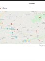
KEY FOR THE MAP:
1. Justo Smoker residence (roughly)
2. Abduction (exactly) - 1242PM
3. Amish Road sighting (roughly) 115PM
4. Harvest Structures (3104 Harvest Drive) 230PM-330PM
Top right X: welsh mountains
Bottom right X: Dutchland Inc (where Smoker works)


")