Missing Texas State student Jason Landry was in car crash: DPS | khou.com
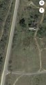
This article included a map. It doesn’t state an exact location on Salt Flat Rd, but if you click on the dropped location it may help some (or not

)
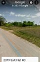
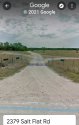
I believe it was determined his car was close to 2379 address.
Are those two houses on the map posted above around that address on Salt Flat Rd?
And in regards to the pond, I did find this link:
Texas college student missing for SEVEN days after crashing his car on the way home for Christmas - DUK News
It describes the searches, including the following info:
Members of Texas Search and Rescue have been combing
a two-mile radius of the crash site.
Are the houses and the pond to the east on the map in the above post in that 2 mile radius?