2020 Hurricane Season Starting Early, "High Activity" Expected This Year

National Weather Service Facebook post a few minutes ago.

U.S. National Weather Service (NWS)

Tropical Storm Arthur continues to strengthen. Direct impacts to eastern North Carolina expected to begin on Monday.
upload_2020-5-17_11-35-21.png
 
National Weather Service Facebook post a few minutes ago.

U.S. National Weather Service (NWS)

Tropical Storm Arthur continues to strengthen. Direct impacts to eastern North Carolina expected to begin on Monday.
View attachment 247109

And during this season, when shelters may need to be utilized, there is this aspect of “shared spaces” during the “pandemic” at hand...

Some people may be more inclined to not evacuate to a shelter for this reason.

I’m sure the Red Cross, etc. is planning their “socially distanced” shelters as we speak; I imagine them to be not much dissimilar from a “quarantine facility”.
 
Last edited:
My kinda outlook!!

Flhurricane.com

Back to normal for the preseason, with nothing expected to develop over the next week or two. Areas to watch in for the somewhat rare June system usually occur in the Gulf or Western Caribbean, and occasionally a storm just off the east coast, but June typically does not see much development.
 
The people commenting. LOL!!!

Tropical Tidbits

The NOAA Atlantic hurricane season outlook has been released, and expects a more active hurricane season than normal in 2020. Based on the developing La Nina and current Atlantic conditions, I agree with this expectation.

This doesn't necessarily mean many landfalling storms, but it certainly doesn't hurt the chances of landfalls. It's always important to be prepared! Have a hurricane plan ready before the season ramps up, just in case a storm heads your way this year.
 
And next on the line up, Bertha. She pretty much ruined Memorial Day weekend for Florida. Now she’s torturing the east coast.

Tropical Tidbits

We now have Tropical Storm #Bertha this morning. A tight, closed circulation has reformed farther east within the deep thunderstorms as it approaches South Carolina. The primary impact is still flash flooding, with some gusty winds over 40 mph possible. A Tropical Storm Warning has been issued for portions of the South Carolina coastline. Bertha will be over land within the next couple hours and continue dumping heavy rain over South Carolina, spreading into North Carolina and parts of Virginia tonight.
 
Looks like a fish spinner.

Flhurricane.com

This area, being tracked as 92L is far in the central Atlantic, but very unusual for May, has a 30% chance for development. Will likely affect no direct land areas.

810 PM EDT Thu May 28 2020

For the North Atlantic...Caribbean Sea and the Gulf of Mexico:

Corrected website for the High Seas Forecast

Special Tropical Weather Outlook issued to discuss the area of low
pressure over the central Atlantic.

1. A surface trough and associated upper-level disturbance are
producing disorganized shower activity and gusty winds over the
central Atlantic Ocean several hundred miles east-southeast of
Bermuda. Gradual development of this system is possible, and it
could acquire some subtropical characteristics on Friday and
Saturday as it moves generally northward. Development is not
expected after that time due to unfavorable environmental
conditions. For additional information, see High Seas Forecasts
issued by the National Weather Service. The next Special Tropical
Weather Outlook on this system will be issued by 9 AM EDT Friday,
or earlier if necessary.
* Formation chance through 48 hours...low...30 percent.
* Formation chance through 5 days...low...30 percent.

High Seas Forecasts issued by the National Weather Service can be
found under AWIPS header NFDHSFAT1, WMO header FZNT01 KWBC, and
available on the Web at
https://ocean.weather.gov/shtml/NFDHSFAT1.p
 
Good grief.

Flhurricane.com

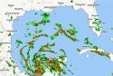
The system (93L, formerly Tropical Storm Amanda from the East Pacific) is currently over the Yucatan Peninsula now has an 80% chance to develop,

Those along the Bay of Campeche in Mexico should watch this, and folks along the Gulf coast from coastal Texas to Louisiana should at least keep up with what's going on here, particularly for Sunday/Monday of NEXT week.

Today marks the first day of the 2020 Atlantic Hurricane season, which has already had TWO named Tropical storms, Tropical Storm Arthur, that formed east of Florida but stayed offshore, closest point to land was in the outer banks. And Tropical Storm Bertha, which formed quickly and made landfall in South Carolina causing some impacts along there, and in the outer banks, as well as a freak training rain system formed by a tail outer band in the Miami area causing major flash flooding.

Last year was most memorable for Hurricane Dorian, which sat over the Northern Bahamas for 24 hours devastating the area and then clipped over the North Carolina Outerbanks.

Once again we’ll be watching out in the Atlantic, and Hawaii if any storms threaten there.

The first regular outlook starts at 2AM on June 1st. And there's already something to track:

Invest 93L, which is the the remnants of Eastern Pacific Tropical Storm Amanda.

Tropical Weather Outlook
NWS National Hurricane Center Miami FL
800 AM EDT Mon Jun 1 2020

For the North Atlantic...Caribbean Sea and the Gulf of Mexico:

A large area of disturbed weather, associated with the remnants of
eastern Pacific Tropical Storm Amanda, is located over the Yucatan peninsula of Mexico. This disturbance is forecast to move northwestward over the southeastern portion of the Bay of Campeche later today or tonight where environmental conditions are expected to be conducive to support development, and a new tropical depression is likely to form within within the next day or so. The
system is then forecast to drift west or west-southwest over the southern Bay of Campeche through the middle of the week. Interests along the coast of the Bay of Campeche should monitor the progress of this disturbance. Regardless of tropical cyclone formation, heavy rainfall is likely to continue over portions of southern Mexico, Guatemala, El Salvador, Belize, and western Honduras during the next few days. For additional information on the rainfall threat, see products from your national meteorological service.
* Formation chance through 48 hours...high...80 percent.
* Formation chance through 5 days...high...80 percent.
 
I like this guy Levy. He does a good job keeping it basic an understandable.

Tropical Tidbits

The circulation from ex-Tropical Storm Amanda is over eastern Mexico, and is likely to re-emerge over the Bay of Campeche and become a new tropical cyclone in the next day or two. Heavy rainfall and potential for flash flooding will continue over a wide swath of Central America.

This storm's long-term future is uncertain. It will stay near Mexico for the next few days, potentially looping around and moving back over land. Eventually, the storm or its remnants are likely to get pulled north by a trough toward the U.S. gulf coast in about a week. It is currently too early to know specifics, but be aware of a potential tropical event somewhere along the gulf coast late this week or early next week.
 
Ugh and the hits just keep on comin’. And it is not Cristobal’s first rodeo either. He was terrorizing the east coast back in 2008 too.

Tropical Tidbits
A good website for info.

https://www.washingtonpost.com/weather/2020/06/02/tropical-storm-cristobal-forms/

Tropical Storm Cristobal was a strong tropical storm that paralleled the East Coast of the United States, traveling from Florida to Nova Scotia. The third named storm of the 2008 Atlantic hurricane season, Cristobal formed on July 19 from a trough of low pressure off the Southeast U.S. Coast. Wikipedia
 

Attachments

  • 3B6F636F-A58B-45E2-AEE2-DD05FF9B347D.jpeg
    3B6F636F-A58B-45E2-AEE2-DD05FF9B347D.jpeg
    136.2 KB · Views: 1
@PayrollNerd et al. -- I have spaghettimodels.com (Mike's Weather Page) bookmarked and like the large number of charts and sources of info on the site, including tweets. I think I learned about the page from Websleuths originally. Do you use the site?

Oops, just went there and got hijacked to another page. That used to happen to me a lot on Websleuths. I went into Safari preferences and removed the offending hijack site... but it's annoying.
No I haven’t used that website. I have followed flhurricane.com for years. They have meteorologists who chat on there. They reference a lot sites providing maps. I’m not sure if they’ve used the one you mentioned.

I try not to bother with the regular media. They create hysteria. Like you, I follow the scientists and want sourced info. Tropical Tidbits is my newest favorite. Levi is starting to get a lot of exposure now. I believe he just graduated.

There is going to be a lot of flooding over the next week. It always seems to be the surprise in a storm for so many. You can’t out run the water and your attic is not a safe space. New Orleans needs to get their people out immediately. Tampa will likely back flush the sewers into the bay like they always do prior to a storm. Those hit by Hurricane Michael in the FL panhandle need to go northeast. The topography there is low flat. There’s no ground high enough in that region.

Also, check the gutters on your house if you’re in the path. I verified my two back gutters are working. I am going to check my side ones when the showers return tomorrow. My lanai roof is leaking now. Sigh.
 
My dad is VP of one of the largest US insurance companies and is tasked with running its catastrophe division. Talked with him yesterday and he already has multiple suitcases packed and has hired someone to take care of his house because he expects to be “on the road” for most of this year dealing with all of the post hurricane clean up efforts :(
 

Members online

Online statistics

Members online
154
Guests online
468
Total visitors
622

Forum statistics

Threads
625,576
Messages
18,506,431
Members
240,817
Latest member
chalise
Back
Top