Is that outside of the Cosy Corner area?The last ping round 1 pm of June 1st is supposed to have come from somewhere in the area West of the lighthouse and in an angle of 60 degrees from the cell tower:


You are using an out of date browser. It may not display this or other websites correctly.
You should upgrade or use an alternative browser.
You should upgrade or use an alternative browser.
Australia Australia - Theo Hayez, 18, Belgian backpacker, Byron Bay, June 2019 #2
- Thread starter Beagle
- Start date
- Status
- Not open for further replies.
If I was going to try and head up towards the lighthous, or around that way, I might try to head up through the bush at first and either try and cut across the Ridge to the headland or head generally towards the car park before the lighthouse.
You can see some trails up that way.
My partner dropped her phone across from that car park and I went over and retrieved it. I pondered about access down to CC from there and there had been human access.
I might also sit and ponder if I reached an obstacle.
You can see some trails up that way.
My partner dropped her phone across from that car park and I went over and retrieved it. I pondered about access down to CC from there and there had been human access.
I might also sit and ponder if I reached an obstacle.
I still remember sitting at CC myself and put in google maps the way back to WU from that spot and for some reason my maps told me to go to the tallow ridge track!! At the time I did ponder if Theo thought there was a way to get there from CC..
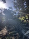
I tried it myself and it was very very hard. There’s an old fence there, which has a reasonably sized open grassy area behind it (which at the time had a fair few burnt bits of wood so obvious people have fires there, def can see it being used as camp fire party site). Once you get through the open grassy area there’s quite a bit of vegetation there, in fact there was one area in particular that was quite dense and rugged, very prickly. To the right of the vegetation there was a way to go with no vegetation but was seriously steep, you could get up it and I did try and I got quite high, but only had thongs on at the time and was worried about losing my footing and going into the dense prickly scrub so went no further!!
I tried it myself and it was very very hard. There’s an old fence there, which has a reasonably sized open grassy area behind it (which at the time had a fair few burnt bits of wood so obvious people have fires there, def can see it being used as camp fire party site). Once you get through the open grassy area there’s quite a bit of vegetation there, in fact there was one area in particular that was quite dense and rugged, very prickly. To the right of the vegetation there was a way to go with no vegetation but was seriously steep, you could get up it and I did try and I got quite high, but only had thongs on at the time and was worried about losing my footing and going into the dense prickly scrub so went no further!!
Chiatos, was the 6am ping in this triangle as well, do we know?The last ping round 1 pm of June 1st is supposed to have come from somewhere in the area West of the lighthouse and in an angle of 60 degrees from the cell tower:
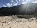
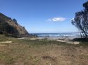
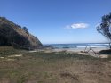
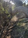
Just wanted to ad some picks I took from the day. Just to try and show what it’s like to some degree.
The first pic top left is looking up towards the grassy area
Second and third pic are looking towards the beach inside grassy area
Fourth, fifth and sixth pics are of the back of the grassy area, trying to get to tallow ridge track.
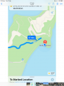
Second last pic is my gps location trying to make it to the tallows ridge track
Last pic is the original putting the location in from where I was sitting.
The first pic top left is looking up towards the grassy area
Second and third pic are looking towards the beach inside grassy area
Fourth, fifth and sixth pics are of the back of the grassy area, trying to get to tallow ridge track.
Second last pic is my gps location trying to make it to the tallows ridge track
Last pic is the original putting the location in from where I was sitting.
Attachments
-
 7172E9B3-5D56-435C-9CEC-A560C4AFF926.jpeg186.6 KB · Views: 145
 -
 CA809FD8-FFE9-4BB6-BB52-BCD0DD26CDEB.jpeg196.2 KB · Views: 155
 -
 B1A00C6B-D7DB-4250-A945-D34C9F95ADB2.jpeg165.9 KB · Views: 149
 -
 0B502DF9-5142-4092-8090-BB324C4AE00E.jpeg338.8 KB · Views: 176
 -
 1B2606DF-12F4-4A81-82E5-D0E9BC674E77.jpeg199.6 KB · Views: 166
 -
 9CCE9CB2-2BCE-4BAC-A8AD-0392BC221B23.jpeg309 KB · Views: 170
 -
 514BB153-8C8C-418F-A563-8BDB595AAC5D.jpeg98.5 KB · Views: 165
 -
 E3C40B19-57B0-4F9D-98BF-7DFD117F556B.png375.1 KB · Views: 124
Last edited:
This drawing of mine is based on the info given in podcast#2.Chiatos, was the 6am ping in this triangle as well, do we know?
Perhaps the 60 degrees angle should be shifted more to the right or more to the left, who knows. It's an approximation based on the given info.
CC might or might not be within that angle.
The location of the phone at the time of the 6am ping has not (yet?) been mentioned.....
Ok, thank you. It may still be in the CC range then....This drawing of mine is based on the info given in podcast#2.
Perhaps the 60 degrees angle should be shifted more to the right or more to the left, who knows. It's an approximation based on the given info.
CC might or might not be within that angle.
The location of the phone at the time of the 6am ping has not (yet?) been mentioned.....
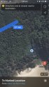
Thanks for the info! T, did you manage to get beyond your blue dot? Or was that spot your maximum reach?Just wanted to ad some picks I took from the day. Just to try and show what it’s like to some degree.
The first pic top left is looking up towards the grassy area
Second and third pic are looking towards the beach inside grassy area
Fourth, fifth and sixth pics are of the back of the grassy area, trying to get to tallow ridge track.
Second last pic is my gps location trying to make it to the tallows ridge track
Last pic is the original putting the location in from where I was sitting.
It's deceptively steep compared to a Google Earth view.Just wanted to ad some picks I took from the day. Just to try and show what it’s like to some degree.
The first pic top left is looking up towards the grassy area
Second and third pic are looking towards the beach inside grassy area
Fourth, fifth and sixth pics are of the back of the grassy area, trying to get to tallow ridge track.
Second last pic is my gps location trying to make it to the tallows ridge track
Last pic is the original putting the location in from where I was sitting.
I do remember that map, which lead me to the theory Theo was looking at a way back to WU...
Still strikes me as odd; if running from someone, why not go to a house if he/they felt in danger....or run toward town? Even if they did go the track to Tallows, then why not head toward a campfire on the beach, if there was one?
And no messages sent after the "prickly area" indicated Theo was in danger....i'm more confused really.
He didn’t because he couldn’t?
Was he avoiding the carpark (hence veering off onto the beach track just before it)?
Was he cornered at CC and attempted unsuccessfully to exit up through the bush on the cliff?
Did he then try the ocean side of the cliff?
the blue spot was pretty much as far as I got in.Thanks for the info! T, did you manage to get beyond your blue dot? Or was that spot your maximum reach?
At night going that was would be so hazardous IMO. However I sometimes wonder with the amount of tracks that seem to go trough that whole section of scrub on tallows whether Theo thought it could be done, went for it and something happened?
On my gps when I was there, the tallow ridge track says it’s a 57 min walk to WU (from the actual track, not from CC) but if you drop a pin on CC to WU it’s 52 mins, it’s not like going to the tallow ridge track way would have saved time.
One thing I do remember is there was a fair amount of broken police tape all in behind the grassy area, seemed well searched but maybe wasn’t well searched but just searched?
From the Australian article posted last night
‘A new episode of The Australian’s investigative podcast, The Lighthouse, to be released today, also reveals that after getting to an area at Tallow Beach known as Cosy Corner, Theo went up a densely vegetated hill.
He stopped amid a tangle of vines, in a completely private area above the beach, for 5½ minutes.
“This is why I think he was hiding,” Byron local Sheri D’Rosario said in a sunset visit to the site, retracing Theo’s route for the podcast series. “The branches are horizontal and there’s vines with sharp prickles everywhere.
“It’s very sort of dark in here. At night it would be absolutely pitch black and it’s hidden from the beach, so nobody around will be able to see in and even know that we were here.”
I’m convinced the area I went into behind The grassy area at CC.p is what they are talking about. I posted some pics last night but I’ll put another one up, similar to one I posted, I just wanna highlight that IMO this is the raised area they talk about in this quote from the coming episode of the podcast.
Attachments
“He stopped amid a tangle of vines, in a completely private area above the beach, for 5½ minutes.”
Interesting how they can almost pinpoint where Theo was standing, sitting or crouching. I guess podcast 4 today will explain a lot more, and that the accuracy is down to what cousin Michael was saying about seeing within 3 metres where Theo was along the way. It’ll be also interesting to see if they then discuss if he ventured to the opposite side of CC against the cliffs and ocean.
Interesting how they can almost pinpoint where Theo was standing, sitting or crouching. I guess podcast 4 today will explain a lot more, and that the accuracy is down to what cousin Michael was saying about seeing within 3 metres where Theo was along the way. It’ll be also interesting to see if they then discuss if he ventured to the opposite side of CC against the cliffs and ocean.
- Joined
- Jul 18, 2019
- Messages
- 91
- Reaction score
- 332
So if mapping stops at 12.05 then this puts Theo close to the beach waterline at 12.05, after he leaves the prickly area. Theo is on his phone from 12.23 am, 18 minutes after he switches off tracking. Did Theo turn off mapping to save power then decide to watch youtube if worried about battery? Or did Theo turn off mapping worried about being tracked by someone who knew his phone number? First flight, then think of this possibility so to make sure he switches off Google Maps. All someone needs is his phone number and can find his location through "find my phone" or there are other easy methods. Taking into consideration it does appear he was trying to escape someone this is a real possibility. If so then this means whoever was after him had his number. Also between 12.05 when he must have changed settings on his phone to 12.23 am when he began using his phone there is a period of 18 minutes in between. If not on his phone, then what was he doing in those 18 minutes in between? This points to somebody else being with him, as do other clues, such as the choice of Milne Track, bush routes etc. In those 18 minutes in between IMO he was engaging with someone, talking. If alone he would have likely used phone sooner, and also be more likely to be trying to get home rather than sitting there on a dark night with no moon. If Theo was going to try climb the cliff to get to the lighthouse why didn't he do it when he thought he was in danger? He was hiding rather than try climb cliff which would have been quite impossible at night anyway. I don't think Theo went into a prickly area for the toilet, pitch black night why even need privacy? Why go into a difficult area? IF for privacy then there must have been others present but still he would not need to go into such an area for privacy anyway. I doubt anyone could see more than a few feet ahead. It all points to Theo escaping someone, and more than likely he had company who was escaping with him, and more than likely company he met at Tennyson St. where he was for 7 and a half minutes. It does not seem logical to be almost running to go to a doof party through thick scrub in pitch black. I believe something happened at Tennyson St., and he was either with someone who was in a hurry to get away or Theo needed to get away. Turning off his Google Maps may have been for a different reason than to save battery, it is very possible whoever he was escaping had his phone number and with that the potential of easily finding his location.
- Joined
- Jul 18, 2019
- Messages
- 91
- Reaction score
- 332
One part I don't understand is why didn't Theo's phone use the closest tower at the lighthouse on the final ping at 1.42 next day. Doesn't this suggest that the phone at that time was closest to the Paterson St tower? Are there any other explanations as to why his cell phone would us a tower which is further away? Police searching the cliffs at the lighthouse yet Theo's last phone ping comes from a tower near town? I understand that the ping location covers the Cape area but why didn't his phone use the closest tower. I am very interested to see why the detectives believed he came off the cliff at the lighthouse when his phone ping came from the Paterson St tower. I mean if Theo was presumed to have fallen off or had an accident there, dropped his phone would expect the phone to ping the Lighthouse tower, not Paterson. So from what I gather his phone was closer to town next day rather than the lighthouse. So either someone walked off with the phone IF police believe Theo had misfortune on the cliff, or Theo was still with his phone in a different area away from the lighthouse, closer to Paterson. Are there any other explanations?
mishachilli
Member
- Joined
- Nov 18, 2019
- Messages
- 36
- Reaction score
- 52
This new detail could also explain someone else running with Theo’s phone and hiding in the vines and bushes.
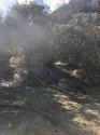
Media mention those prickly vines and a 'tangle of vines', but to be honest their images don't impress me. Are those trees supposed to be vines? There seems to be sufficient clearing around them not to be pricked. I have a totally different idea of 'prickly and tangled vines':

sparks030405
#TourismTrumpsTheo
- Joined
- Jul 15, 2019
- Messages
- 106
- Reaction score
- 338
Podcast 3 is a no show. Some more facts. I emailed the producer with a link to local gang culture and comments from their parents and get a reply saying that’s timely and is going to be in Podcast 3. I emailed another two times about a ‘Missing person’ possibly related to TH and get no response. The silence is deafening
Last edited:
- Joined
- Sep 6, 2015
- Messages
- 1,453
- Reaction score
- 7,655
Media mention those prickly vines and a 'tangle of vines', but to be honest their images don't impress me. Are those trees supposed to be vines? There seems to be sufficient clearing around them not to be pricked. I have a totally different idea of 'prickly and tangled vines':
Although Lantana is not classed as a vine, looks like Lantana to me and IMO
- Status
- Not open for further replies.
Similar threads
- Locked
- Replies
- 997
- Views
- 104K
- Replies
- 690
- Views
- 131K
- Locked
- Replies
- 1,345
- Views
- 228K
- Replies
- 2
- Views
- 3K
- Replies
- 2
- Views
- 1K
Guardians Monthly Goal

Goal Reached! We hit our target of 75 new Guardians!
New stretch goal: 100!
Our goal for the month is 75 new Guardians members to sign up. Have you been thinking about becoming a member?
Click here to find out how!
Online statistics
- Members online
- 70
- Guests online
- 2,330
- Total visitors
- 2,400
Totals may include hidden visitors.
Forum statistics
Community Rules
-
Be CivilTreat all members with respect. No personal attacks, harassment, or inflammatory language.
-
Victim FriendlyAlways show respect for victims and their families. No victim blaming or insensitive speculation.
-
Fact-based SourcingProvide credible sources for claims. Distinguish between verified facts and personal theories.
-
Social Media UseDo not post direct links to personal social media profiles of private individuals.
-
Copyright and PaywallsDo not copy full articles. Summarize and link to the original source instead.
-
Privacy and Personal InformationDo not post personal information such as addresses, phone numbers, or workplaces.
-
Registered Sex-OffendersDo not name or speculate about RSOs unless officially named in connection to a case.
-
Stay On TopicKeep discussions relevant to the case or topic at hand. Avoid off-topic tangents.
-
Accounts, Moderation, and DisputesOne account per person. Contact moderators privately for disputes or concerns.
-
Solicitation and FundraisingNo solicitation, fundraising, or promotion of personal ventures without approval.