

lilblue
New Member
- Joined
- Feb 18, 2013
- Messages
- 69
- Reaction score
- 529
Much to my surprise, CNN explained this rather well yesterday afternoon.
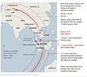
ONE satellite sends a "handshake" (i.e., automatic signal) to ONE plane and the plane responds. The time it takes for the signal to get to the plane and return gives them the distance ("X miles") between the satellite and the plane. (Signals travel at a constant speed: the speed of light.) (This process is repeated hundreds of times per hour with hundreds of planes.)
But one ping can't tell them the direction the "handshake" travelled. So they are left with a circle around the satellite of X miles in all directions.
That circle has been narrowed down to the two arcs based on factors like time travelled, amount of fuel, speed capacity of the 777, etc. But there is nothing (except human hunches) to say whether the flight went north or south. (It didn't have enough time or fuel to reach the east and west quadrants of the circle by 8:11.)
It would take a SECOND satellite to enable them to triangulate (remember Pythagoras) and pinpoint the actual location of the plane at the time of the ping. GPS uses three satellites and, with a fourth one, can also give altitude of the plane (or your car).
Bottom line: if the "ping" info is correct, then the plane was somewhere along one of those arcs at 8:11 a.m. It does NOT tell us anything about which way the plane was headed or how it got to that point. They estimate MA370 had about an hour of fuel left at the time of the ping, so they are searching an area about 200 miles on both sides of the arcs.
What I'd like to see is the arcs created for all the pings, not just the last one. They have this data of course, but I'd really like to see it to get an idea of their direction of travel from the last known radar position.

 lease: